Tsunami」カテゴリーアーカイブ

Day_168 : Past Interview Records – PTWC (Pacific Tsunami Warning Center) in Hawaii (1)

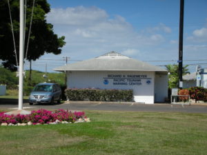
Continue to the past New Orleans Interview Records, I would like to open the memo about the interview to PTWC. It was a great time and I learned a lot from the interviews.  So I would like to share the fact to let you know their works to tackle the tsunami disasters in the world.

PTWC is the core center for the tsunami warning well known to the world.

2008.2.26 (Tue.) at 1000 am
15 staff, director, deputy director
Information Technician, including nine scientists
16-hour shift on 8-4-4, homes are next to the center

The records from the interview survey are shown below.
■ Evacuation
There is no international standard in terminology. Terminology varies by country/region. The words sometimes make me confused. Also, in the past, it was two either evacuation nor no evacuation.

■ Warning Error
It is challenging to give a warning. There are errors in the original earthquake and the tide data. There is an error in the gauge also.
To judge them collect is too hard. So, it can be said that 99.99% is an error.

In Hawaii, only a quarter of evacuation was actually damaged in the past. It is not unusual that although there were evacuations, there were no damages at all.

■ Past data and warning judgment
Only use a few. Because how to put out the past data, equipment, etc.are hard to do. Which way is the numerical model used to determine if the earthquake becomes a tsunami is complicated. There are more things to do.

■ Relationship with other countries
The countries that are most focused on warning about tsunami in the Pacific are Japan, America, Australia, Chile, Canada, and Russia. Also, it is not possible to evaluate the inspection records of other countries. This should be noted.

■ At the time of the 2004 tsunami
Most of the records before the Indian Ocean Tsunami were reported hourly, so judge the event was tough. Every 15 minutes, now every 6 minutes is normal and very good.

■ Conditions for cancellation
Make a comprehensive decision. The problem of reflections adds to the complexity. Not only direct waves but also an indirect wave should be considered.

Day_157: Disaster Warning (1)

I will update a column of the NIED e-mail magazine which I wrote a long time ago because the content is not faded with time. (I will do this step by step in Japanese and English) I will also add comments to update the situation.

Sorry, now I am revising this post because of the difficulties of the translation. This post will be revised again. Thank you.

Published May 6, 2010
NIED-DIL e-mail magazine: Disaster Warning (1)

■ Disaster Warning (1) ■

In February 2008, a survey provided an opportunity to visit the Pacific Tsunami Warning Center (PTWC) in Hawaii. In a study, I interviewed the director of the PTWC, and the first thing that caught my attention was the role of the media. The director told me that a public tsunami evacuation alert required three hours before the event, which was too time-sensitive, but the media was an advantage to do this. However, for the government organization, there were various restrictions, such as warnings in an international framework. I remembered the Chilean Navy’s disaster response to the damage caused by the earthquake and tsunami in Chile in February this year.

Next, I was interested in science, technology, and data that are the basis of the alarm decision. I think that normal (flood etc.) warnings will be judged based on current and past data, but especially for tsunami warnings, there were errors in the data of the original earthquake and the tide gauge. To do judge, we should know the 99.99 percent could be the error. The fact that the past data is not very useful because the devices to figure out the data are changing day by day, making it difficult to rely on it.

From these facts, it was generally noticed that the disaster warning was based on the combination of the progress of science, technology and the competence of the person in charge. The actual warning also relies on the institution belonging to it. For example, it was also needed to add variables such as the recipient of the alert, the psychology of the local people, social situation, and various systems.

Issued May 6, 2010 No. 4

Ref.

https://disasterresearchnotes.site/archives/2592

Day_142 : World Disaster Chronology-1994-1995


Date Place Disaster Type Situations
1994.01.17 US, Southeastern Inland Earthquake 1994 Northridge earthquake *
M6.8, 60(D), one of the costliest natural disasters of US history
1994.02.15 Indonesia, West (Sumatra Island) Inland Earthquake M6.6~7.0, Over 200(DM)
1994.05- Bangladesh Cyclone Over 170 (DM)
1994.05.13 Afghanistan Inland Earthquake M6.0, Over160(DM)
1994.06- India / Pakistan Heat Wave Over 400 (D)
1994.06- Ethiopia Drought Over 5,000(D), Food shortage
1994.06- China, Central eastern Heavy Rain, Flood Over 700(DM), A part of Shanghai was inundated
1994.06.02 Indonesia, South (Java Island) Submarine Earthquake M7.8、死不270以上、津波。
1994.06.06 Colombia, South Inland Earthquake M6.6, 300-800(DM), Debris flow
1994.06.09 Bolivia, Peru Deep-focus Earthquake 1994 Bolivia earthquake M8.2 10(D)
1994.07- Rwanda Heat Wave Over 10,000(D), combined with Civil War
1994.08.18 Algeria, North Inland Earthquake M5.7, Over 150(DM)
1994.10.04 Japan, Kunashiri Island Submarine Earthquake The 1994 Hokkaido Toho Oki Earthquake M8.2-8.3, 15(DM), Tsunami
1994.11- India South Cyclone 190(DM)
1994.11.14 The Philippines Inland Earthquake M7.1 Over70(DM) Tsunami
1994.11- Italy Heavy Rain, Flood Over 60(DM)
1994.11- Egypt Lightning 560(DM) Lightning damage to Oil facilities
1994.11- Haiti, Cuba Hurricane, Flood Over 700(DM)
1995.01.17 Japan Inland Earthquake The 1995 Great Hanshin Awaji Earthquake * M6.9~7.3 5,500~6,400(DM)
1995.03- Afghanistan Heavy Rain, Flood, Landslide Over 360(DM)
1995.04- Bangladesh Strong Wind 700(DM)
1995.05.27 Sakhalin, North Inland Earthquake The 1995 Neftegorsk earthquake,M7.1~7.5, Over 1,989(DM) Neftegorsk city was destroyed and vanished from the map after the disaster
1995.05- Brazil Heavy rain, Flood. Landslide Over 80(DM)
1995.05- China Heavy rain, Flood Over 1,100(DM), Yangtze river flood
1995.06- India, Pakistan Heat Wave Over 800(D)
1995.06- Japan Heavy rain, Flood 9(DM), Destroyed Approx.200, Inundated over15,000
1995.07- US Heat Wave Over 800(D)
1995.07- D.P.R.Korea Heavy rain, Flood Over 60(DM)
1995.07- Thailand Heavy rain, Flood Over 200(DM)
1995.08- Morocco Heavy rain, Flood Over 150(DM)
1995.9- The Philippines Heavy rain, Flood Over 540(DM)
1995.11- The Philippines Typhoon, Flood Over 780(DM)
1995.12-  Kazakhstan Cold Wave Over 100(DM) Snowstorm

D: The number of Death M: Missing number DM: The dead and missing number

https://disasterresearchnotes.site/archives/2831

Related articles across the web

Day_133 : Science, Technology, Population, and Lessons for DRR

Japanese people have tended to trust the government and science & technology so much.
These are one of what we learned from recent disasters. After the second world war, Japanese gov. has built high sea walls along the coastline especially potential risk areas all over Japan. We have also developed warning systems along with rapid economic growth. Not only those, but we have also developed soft countermeasures such as disaster education and training, especially after the 1995 Kobe Earthquake. After the Great East Japan Earthquake and Tsunami (GEJET) disaster, we have realized what has happened because of our over trust to the government and science&technology. This is why Japanese gov. has particularly focused on the community since the disaster, establishing a new frame on the community disaster planning in the disaster countermeasure basic act. The recovery plans on the affected coastal communities tended to change more integrated manners and so did disaster countermeasures than before, looks like turning back to the time when we did not have advanced science and technologies.

We need to know the limitations of the gov. and science&technology’s roles. We also can consider the demographic change to do the job for disaster risk reductions. For example, Japan is facing a severe aging society, so our government resources will be decreasing to cover the situations. We need to have more self-help and mutual help than public help.

Learning from the lessons and past wisdom with those considerations is also very important. “Inamura no Hi” is one of the important lessons we can learn from the past.

http://disasterresearchnotes.site/archives/2720

“Inamura no Hi” is a story of a man who noticed a precursor of a large tsunami at the earliest stage and led village inhabitants to a higher ground by burning harvested rice sheaves. This story was based on a true story at the time of Ansei-Nankai Tsunami (1854), which claimed around 3,000 lives in the coastal areas of Western Japan (ADRC).

Hirokawa Town’s video well explains the background of the story in short and their tsunami disaster education.


Day_105 : Relocations or Rebuildings (2)


http://disasters.weblike.jp/disasters/archives/2950

After the 1896 Meiji sanriku tsunami, many communities considered relocating to higher grounds, however, a few communities could proceed the relocations. The main reasons why they could not relocate to higher grounds are the followings (Nakasu et al., 2011):

1) It was very inconvenient for them to settle the areas which were far from the sea because they were mainly fishermen or living their daily lives by the sea.

2) Most of them were doing small size fishing related businesses, had not enough budgets to relocate.

3) There were difficulties to attain the agreements to do relocations among the community members.

4) They, community members, had conflicts with land owners to select and purchase the relocation lands.

5) There were technical limitations to create a land for living on the slope because Japan did not have enough technological level at that time.

They mainly relocated to higher grounds by their own decisions. However, some groups gave pressures on the people who had planned to move and tried to let them give up to do so because they would like to maintain the communities to recover.

A small number of the communities moved to higher grounds, however, some went back to their original places. In addition, their relatives or other village people started to live there. Some families positively accepted the immigrants from outsides to maintain their ownerships.

Finally, almost all communities had chosen to rebuild at the same places, so the risks were retained and this combined with the fact that they were re-affected by the 1933 Showa sanriku tsunami disaster.

Concerning after the 1933 Showa sanriku tsunami, this will be explained later.

Day_101 : Deth toll tells

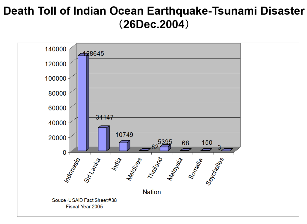
The following Figure 1 is the death toll by country after the 2004 Indian Ocean Tsunami disaster.

death toll
Figure 1 Death toll by country

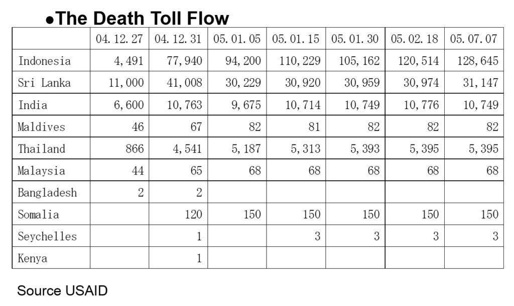
Then Table 1 indicates the death toll flow of each country.
What can we say about this?

Table 1 The Death Toll Flow
Death Flow

As you can see Table 1, the number of victims (deaths) is changing day by day. For instance, the number of deaths reported in Indonesia from 05.01.15 to 05.01.30 is decreasing. The death toll flow of Somaria looks somehow strange. If we can consider these kinds of views, we can understand that the reported death numbers reflect the social situations of the country. These views will be discussed later.

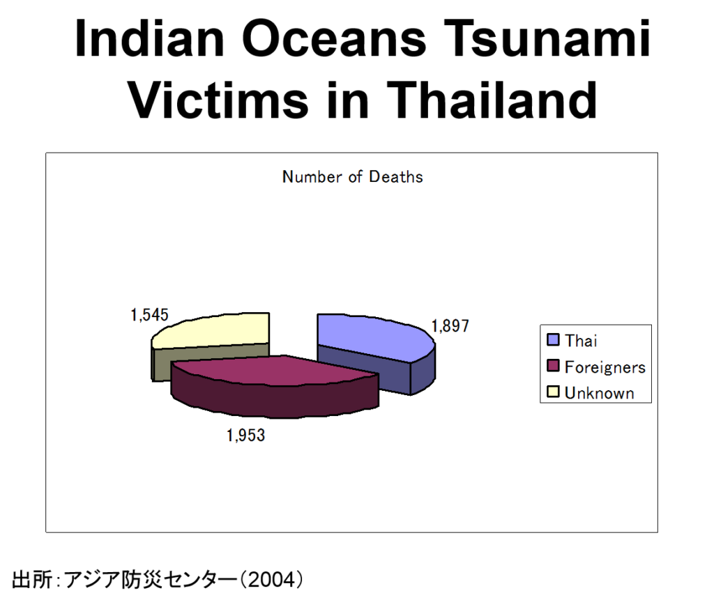
Next, Figure 2 shows the picture taken at the tsunami memorial meeting in Phang Nga province one year after the disaster. This definitely indicates so many foreigners were killed by the tsunami. Figure 3 support this fact. This is because the affected areas were sightseeing spots. Even Thai victims include so many visitors from all over the country.

pictures of memories
Figure 2  The Picture of the Tsunami Memorial Board

tsunami victims
Figure 3 Indian Oceans Tsunami Victims in Thailand

The victim’s nationality is so diverse.Figure 4 indicates the top 10 deadliest disasters (actually top 6 exist) in Sweden and you can know the Indian ocean tsunami is ironically the worst natural disaster in the history of Sweden (The fatality number is 543 Wikipedia).

sweden
Figure 4  Deadliest Disasters in Sweden (1900-2014) Source: EM-DAT

[ad#ads1]

Day_98 : The Major Tsunami disasters in Sanriku Ria Coast in Japan

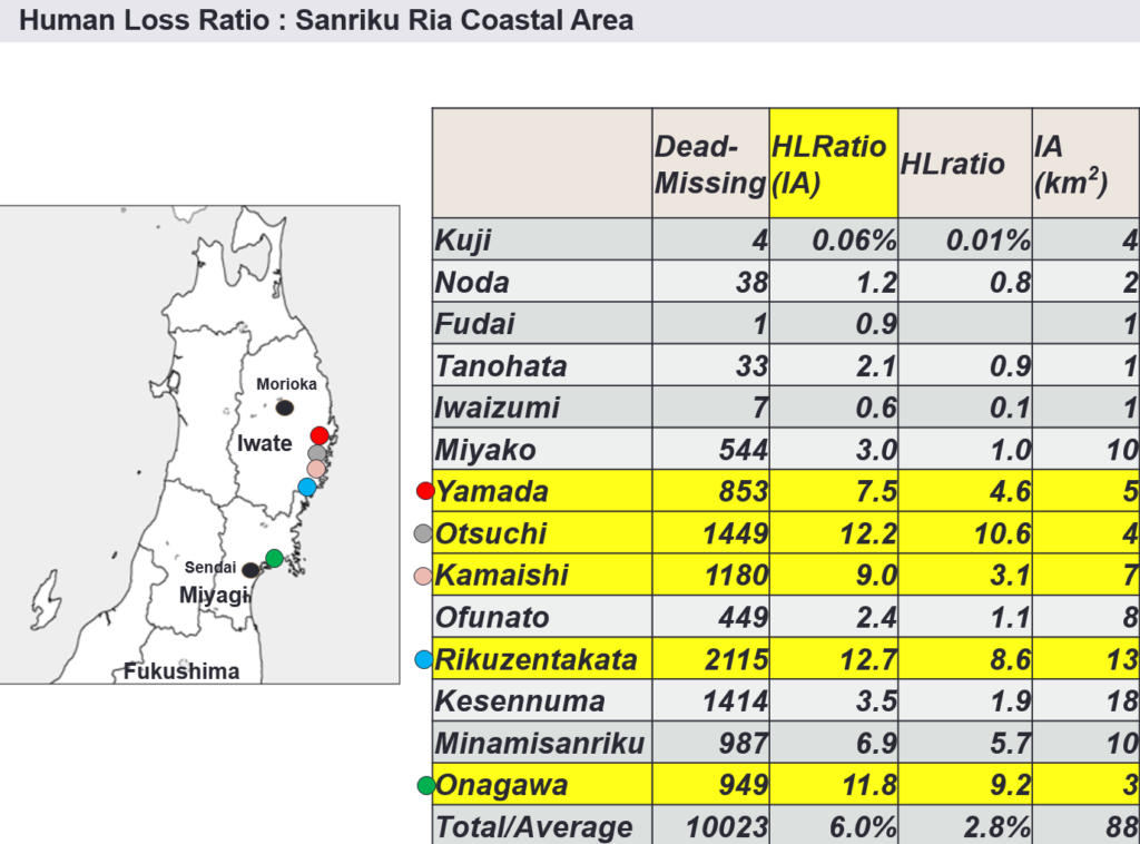
The following slide indicates the Great East Japan Earthquake and Tsunami(GEJET)disaster’s data by each municipality (IRDR conference).You can see the fact that Sanriku ria coast has more severe damage compared to the population of the municipalities.We also need to notice the Sanriku ria coast has a long history of tsunami disasters.But why did they have a sever damage again?

sanriku tsunami history death
Figure 1 Tsunami Disaster Impact in the Sanriku Ria coast (IRDR)

The Sanriku areas have a special geographical condition mentioned as Sanriku ria coast. The coast has mountains close to the sea, so residential areas are limited only in the distributed, narrow and lower zones near to the sea and the areas become very vulnerable against the tsunamis. The bays in the coast are small and the sea inside the bays are very deep. This makes tsunami faster and higher, this is why the Sanriku ria coast makes the one of the highest tsunami risk areas in the world.

Because of these characteristics, the communities in Sanriku ria coast, mainly in Iwate prefecture historically has been severely affected by tsunami disasters such as Meiji Sanriku earthquake tsunami (Meiji (1896)), Sowa Sanriku earthquake tsunami (Sowa (1933)), and Chilean earthquake tsunami (Chilean (1960)) disasters compared to the flat coast mainly in Miyagi prefecture and other areas in Japan.

See the below “Relocation or Rebuilding (1)”

http://disasters.weblike.jp/disasters/archives/2950

The following is the brief explanations of each tsunami disaster. The Figure 2 (Figure 1 of the Day_94 post) does not include the Chilean Tsunami.

sanriku tsunami history
Figure 2
 The Tsunami Disasters in Tohoku (Cabinet office of Japan)

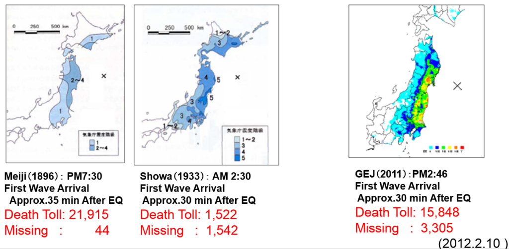
1) Meiji sanriku tsunami disaster(1896), this disaster is so called a surprise attack tsunami disaster happened at approx. 7:30 pm, 15th of June in 1896 mainly in Sanriku ria coast. The dead and missing number has reported over 22,000. The earthquake is not so strong (Japanese earthquake scale indicates Shindo 1-2), however, tsunami is very strong and high (max. height is 38.2m at Ayasato area (present Ofunato city) compared to the earthquake movement scale. The first wave arrival is approx.35m after the earthquake. The Meiji sanriku tsunami disaster (1896) is the worst tsunami disaster ever in Japan.

2) Showa sanriku tsunami disaster(1933), this tsunami disaster can be examined the lessons learned from Meiji (1933) mitigate the impacts. This tsunami attacked mainly the Sanriku ria coast at approx. 2:30 am, 3rd of March in 1933. Even if the midnight, the residents evacuated so quickly because of their memories of the Meiji (1896) with strong earthquake (Japanese scale is Shindo 5.5). The max. tsunami height is 23m at the same place, Ayasato area, with Meiji (1896). The first wave arrival is approx.30 min. after the earthquake.

3) Chilean tsunami disaster(1960), this is caused by the tsunami generated offshore in the long distance. This is coming from Chile in South America. The earthquake occurred in Chile was magnitude 9.5 and this huge earthquake generates tsunami and reach to Japan after 22 hrs and a half. The tsunami come approx. at 3 am, 23rd of March in 1960. The death number is 139 all over the Japan and Sanriku ria coast is the worst such as 63 in Ofunato, 37 in Shizugawa (present Minamisanriku), and 8 in Rikuzentakata.

4) Great East Japan Earthquake and Tsunami(GEJET) disaster(2011), this disaster is the deadliest disaster after the Second World War in Japan. The earthquake happened at 2:46 pm, 11st of March in 2011. The total casualty number is 19,846 based on the EM-DAT.The max.tsunami height is 40m at the Sanriku ria coast. The first wave arrival is approx. 30 min. after the earthquake.

Day_97 : World Disaster Chronology 1976 (2)


Date Place Disaster Type Situations
1976.08.17 The Phillipines, South
Mindanao
Submarine earthquake 1976 Moro Gulf earthquake and tsunami*: M7.8-8.1,A dead and missing number is 4,000-8,000
1976.09- Japan Typhoon 1976 Typhoon No.17 Flood (Nagara river flood
A dead and missing number is 169, Injured 400
1976.10.28- Japan, North-eastern Strong wind Sakata conflagration: A death and missing 2, Injured over 900
1976.10.29 Indonesia, East Irian Jaya Inland earthquake M7.2, A death and missing number is 100-6,000not confirmed),landslide
976.11.24 Turkey and Iran border Inland earthquake  1976 Çaldıran–Muradiye earthquake**: M7.2-7.6, A death and missing number is 3,600-10,000
1976.12- Japan Snow  A death and missing number is 84, Injured over300, damage loss 40 billion yen

1976 Moro Gulf earthquake and tsunami*
The worst tsunami disaster in the Philippines.1) It happened while most people were sleeping.
2) No warning after the earthquake.

1976 Çaldıran–Muradiye earthquake**
The almost all houses were destroyed because of the structure constructed of thick walls made from rubble masonry cemented with mud mortar.

[ad#ads1]

Day_88 : Inamura no Hi

“Inamura no Hi” is a story of a man who noticed a precursor of a large tsunami at the earliest stage and led village inhabitants to higher ground by burning harvested rice sheaves. This story was based on a true story at the time of Ansei-Nankai Tsunami (1854), which claimed around 3,000 lives in the coastal areas of Western Japan (ADRC).

Based on the information from ADRC, 8 countries, language versions were released:  Bangladesh, India, Indonesia, Malaysia, Nepal, Singapore, Sri Lanka, and the Philippines.
Thai language version was also found.

This story became famous after the 2004 Indian Ocean Tsunami disaster, especially the 2005 UN WCDR (World Conference on Disaster Reduction)  in Kobe. Former Japanese Prime Minister Junichiro Koizumi introduced this story in the Japanese lessons for disaster education (Government of Japan, 2006). Hirogawa Town’s video well explains the background of the story in short and their tsunami disaster education.

Day_72 : 1983 Sea of Japan earthquake

The 1983 Sea of Japan earthquake or 1983 Nihonkai-Chubu earthquake occurred on May 26.The magnitude of the earthquake was 7.8.It occurred in the Sea of Japan. The mortality number was 104 and 100 were caused by the tsunami. The tsunami hit communities along the coast, especially, Aomori and Akita Prefectures and the east coast of Noto Peninsula.
There are three things to share about the tsunami disaster.
The first is the tsunami generated location, the second is the broadcasting, and the third is the victims of school children. The first, there was an ancient tradition which tsunami never hit the coast of the sea of Japan. This normalcy bias* exacerbates the damage. The second, this was the first tsunami disaster  broadcasted all over the world during the time. The people who had homevideo also contributed to the media. The tsunami warning system, wireless tsunami information from the sea of Japan to the local area, to inform local people was improved after the event. The third, 43 school children were hit and 13 were passed away. They were on an excursion. The school teacher could not do anything during the time. The 2011 Great East Japan Earthquake and Tsunami disaster also had some teachers related issues. The both tsunamis were daytime tsunamis.

*Normalcy bias

http://disasters.weblike.jp/disasters/archives/2607