Category Archives: Americas

【Disaster Research】When Nature Meets Human Error: Lessons from History’s Deadliest Volcanic Mudflow 40 Years Ago

Growing up, many of us were taught that natural disasters are inevitable acts of nature beyond human control. This perspective changed dramatically for me when I started working at a research institute. My senior researcher emphatically told me, “The natural disaster is not natural.” This profound statement transformed my approach to disaster research, helping me understand that human decisions often determine whether natural hazards become catastrophic disasters.

The Forgotten Tragedy of Armero

On November 13, 1985, the Nevado del Ruiz volcano in Colombia erupted after 69 years of dormancy. The eruption triggered massive mudflows (lahars) that rushed down the volcano’s slopes, burying the town of Armero and claiming over 23,000 lives. This catastrophe stands as Colombia’s worst natural hazard-induced disaster and the deadliest lahar ever recorded.

What makes this tragedy particularly heartbreaking is its preventability. Scientists had observed warning signs for months, with seismic activity beginning as early as November 1984. By March 1985, a UN seismologist had observed a 150-meter vapor column erupting from the mountain and concluded that a major eruption was likely.

Despite these warnings, effective action to protect the vulnerable population never materialized. The devastation of Armero wasn’t simply the result of volcanic activity but the culmination of multiple human failures in risk communication, historical memory, and emergency response.

When Warning Systems Fail: Communication Breakdown

The Armero disaster epitomizes what disaster researchers call “cascading failures” in warning systems. Scientists had created hazard maps showing the potential danger to Armero in October 1985, just weeks before the eruption. However, these maps suffered from critical design flaws that rendered them ineffective.

One version lacked a clear legend to interpret the colored zones, making it incomprehensible to the general public. Devastatingly, Armero was placed within a green zone on some maps, which many residents misinterpreted as indicating safety rather than danger. According to reports, many survivors later recounted they had never even heard of the hazard maps before the eruption, despite their publication in several major newspapers.

As a disaster researcher, I’ve seen this pattern repeatedly: scientific knowledge fails to translate into public understanding and action. When I conducted fieldwork in flood-prone regions in Thailand, I discovered a similar disconnect between technical risk assessments and public perception. Effective disaster mitigation requires not just accurate information but information that is accessible and actionable for those at risk.

The Cultural Blindspots of Risk Perception

The tragedy of Armero illustrates how cultural and historical factors shape how communities perceive risk. Despite previous eruptions destroying the town in 1595 and 1845, causing approximately 636 and 1,000 deaths respectively, collective memory of these disasters had seemingly faded as the town was rebuilt in the same location.

In the hours before the disaster, when ash began falling around 3:00 PM, local leaders, including the town priest, reportedly advised people to “stay calm” and remain indoors. Some residents recall a priest encouraging them to “enjoy this beautiful show” of ashfall, suggesting it was harmless. These reassurances from trusted community figures likely discouraged self-evacuation that might have saved lives.

My research in disaster-prone communities has consistently shown that risk perception is heavily influenced by cultural factors, including trust in authority figures and historical experience with hazards. In Japan, for instance, the tsunami markers that indicate historic high-water levels serve as constant physical reminders of past disasters, helping to maintain community awareness across generations.

Systemic Failures and Institutional Response

The Armero tragedy wasn’t just a failure of risk communication or cultural blind spots—it revealed systemic weaknesses in disaster governance. Colombia was grappling with significant political instability due to years of civil war, potentially diverting governmental resources from disaster preparedness. Just a week before the eruption, the government was heavily focused on a guerrilla siege at the Palace of Justice in Bogotá.

Reports suggest there was reluctance on the part of the government to bear the potential economic and political repercussions of ordering an evacuation that might have proven unnecessary. This hesitation proved fatal when communication systems failed on the night of the eruption due to a severe storm, preventing warnings from reaching residents even after the lahars were already descending toward the town.

In my research examining large-scale flood disasters, I’ve found that effective disaster governance requires robust institutions that prioritize public safety over short-term economic or political considerations. My 2021 comparative analysis of major flood events demonstrated that preemptive protective actions consistently save more lives than reactive emergency responses, even when accounting for false alarms.

Learning from Tragedy: The Path Forward

The Armero disaster, while devastating, catalyzed significant advancements in volcano monitoring and disaster risk reduction globally. Colombia established specialized disaster management agencies with greater emphasis on proactive preparedness. The

Colombian Geological Service expanded from limited capacity to a network of 600 stations monitoring 23 active volcanoes.

The contrast with the 1991 eruption of Mount Pinatubo in the Philippines demonstrates the impact of these lessons. There, timely forecasts and effective evacuation procedures saved thousands of lives. The memory of Armero remains a powerful reminder of the consequences of inadequate disaster preparedness.

As I’ve emphasized in my own research on disaster resilience in industrial complex areas, building sustainable communities requires integrating technical knowledge with social systems. My work developing social vulnerability indices demonstrates that effective disaster risk reduction must address both physical hazards and social vulnerabilities.

Remember, disasters may be triggered by natural events, but their impact is determined by human decisions. By learning from tragedies like Armero, we can create more resilient communities prepared to face future challenges.

【Disaster News】FEMA Cuts before Hurricane Season: What you need to know

DALLE 20250304

Today, I gonna talk about the FEMA cost cuts.

Hurricane season is just 3 months away, but FEMA just lost 200 employees. Should you be worried?

 The Trump administration has made major budget cuts to FEMA and other disaster agencies as part of a government streamlining effort guided by Elon Musk.

These cuts don’t just affect FEMA – they’ve also hit HUD and NOAA, agencies crucial for weather forecasting and housing recovery after disasters.

States like Texas, which depend heavily on federal disaster funds, could face delayed or reduced assistance during emergencies.

Local officials in Houston, still rebuilding from past storms, now question how these changes will impact their disaster preparations.

 Some Republicans argue these cuts eliminate waste, while critics warn they’ll cripple response times when disasters strike – especially with storms becoming more frequent and severe.

If you live in a disaster-prone area, now might be the time to strengthen your personal emergency plans before hurricane season arrives.

News Source: Houston Chronicle

Day_207 : Lessons from Hurricane Katrina: A Retrospective Analysis and Future Implications for Disaster Risk Reduction


The picture was taken in Mississippi on December 3, 2005.

Nearly two decades have passed since Hurricane Katrina devastated the Gulf Coast, particularly New Orleans, in 2005. As we reflect on this catastrophic event, it’s crucial to reassess our understanding of the disaster, its impacts, and the lessons learned for future disaster risk reduction efforts. This updated analysis incorporates new research, recent case studies, and current best practices in disaster management to provide a comprehensive view of Hurricane Katrina’s long-lasting effects and implications for disaster preparedness.

Revisiting the Data: The Importance of Pre-Disaster Information

One of the most valuable resources for understanding the pre-Katrina landscape was the Greater New Orleans Community Data Center (GNOCDC) website. This data repository provided detailed demographic and socioeconomic information at the parish and ward levels, offering crucial insights into the social fabric of affected areas.

Key Findings from Pre-Katrina Data

  1. Vehicle Ownership: Data from GNOCDC revealed significant disparities in vehicle ownership across New Orleans neighborhoods. For instance, the Lower 9th Ward, one of the most severely affected areas, had a low rate of vehicle ownership. This factor critically impaired residents’ ability to evacuate independently, necessitating government assistance for evacuation.
  2. Socioeconomic Disparities: Analysis of household incomes, education levels, and employment rates across different wards highlighted pre-existing vulnerabilities that exacerbated the disaster’s impact.
  3. Housing Quality: Information on housing stock age and quality provided insights into structural vulnerabilities that contributed to the extent of physical damage.

The Victimization Process: A Multi-Stage Analysis

Understanding the disaster’s impact requires examining multiple stages of the event and its aftermath. Building on the original five-stage model (Pre-disaster, Direct Damage, Social Disorder, Life Environment, and Reconstruction and Recovery), recent research has emphasized the interconnectedness of these stages and their long-term implications.

Updated Insights on Disaster Stages

  1. Pre-disaster Stage:
    • New research highlights the critical role of community-based preparedness programs in enhancing resilience.
    • Studies show that areas with strong social networks and community engagement had better evacuation rates and post-disaster recovery.
  2. Direct Damage Stage:
    • Advanced modeling techniques have improved our understanding of infrastructure vulnerabilities, particularly in flood-prone areas.
    • Recent case studies from hurricanes like Harvey (2017) and Ida (2021) provide comparative data on immediate impact patterns.
  3. Social Disorder Stage:
    • Long-term studies have revealed the persistent psychological impacts of displacement and community disruption.
    • New frameworks for maintaining social order during disasters emphasize the importance of clear communication and community leadership.
  4. Life Environment Stage:
    • Research on environmental health impacts has expanded, including studies on mold exposure and water contamination.
    • The concept of “build back better” has gained traction, influencing reconstruction efforts to enhance resilience.
  5. Reconstruction and Recovery Stage:
    • Long-term studies show uneven recovery patterns, with some neighborhoods thriving while others continue to struggle.
    • The role of federal, state, and local policies in shaping recovery outcomes has been extensively analyzed, offering lessons for future disaster recovery planning.

Emerging Trends in Disaster Risk Reduction

Since Hurricane Katrina, several key trends have emerged in the field of Disaster Risk Reduction:

  1. Climate Change Adaptation: There’s an increased focus on integrating climate change projections into disaster preparedness and urban planning.
  2. Community-Based Disaster Risk Management: Emphasizing local knowledge and community participation in disaster planning and response.
  3. Technological Advancements: Utilization of GIS, remote sensing, and AI for improved risk assessment and early warning systems.
  4. Social Vulnerability Mapping: More sophisticated tools for identifying and addressing vulnerabilities based on socioeconomic factors.
  5. Nature-Based Solutions: Growing emphasis on using natural ecosystems to mitigate disaster risks, such as wetland restoration for flood control.

Actionable Recommendations

Based on lessons learned from Katrina and subsequent disasters, here are key recommendations for enhancing disaster resilience:

  1. Invest in Inclusive Preparedness: Ensure evacuation plans and resources are accessible to all community members, especially those with limited mobility or resources.
  2. Strengthen Infrastructure Resilience: Implement stricter building codes and invest in critical infrastructure upgrades, particularly in vulnerable areas.
  3. Enhance Early Warning Systems: Develop multi-channel, culturally appropriate warning systems that reach all segments of the population.
  4. Foster Community Cohesion: Support programs that build social capital and community networks, which are crucial for both evacuation and recovery.
  5. Integrate Social Vulnerability in Planning: Use social vulnerability indices to inform resource allocation and targeted support in disaster planning and response.
  6. Promote Sustainable Recovery: Implement recovery strategies that not only rebuild but also address pre-existing social and environmental issues.
  7. Continuous Learning and Adaptation: Establish mechanisms for ongoing assessment and incorporation of lessons learned from each disaster event.

The tragedy of Hurricane Katrina continues to offer valuable lessons for disaster risk reduction. By combining data-driven analysis with a nuanced understanding of social and environmental factors, we can work towards creating more resilient communities. As we face increasing challenges from climate change and urban growth, the insights gained from studying Katrina’s impact remain crucial for shaping effective disaster management strategies worldwide.

Hurricane Katrina Disaster Research conducted by NIED(in Japanese)

A comparative analysis of large-scale flood disasters

Day_87 : North and Central Americas – Mt. St.Helens and Mt.Pelee

1. Volcanic Disasters

North America
Mount St.Helens erupted in 1980. Fifty-seven people were dead.
St. Helen’s volcanic eruption was massive. You can see this from the following video.


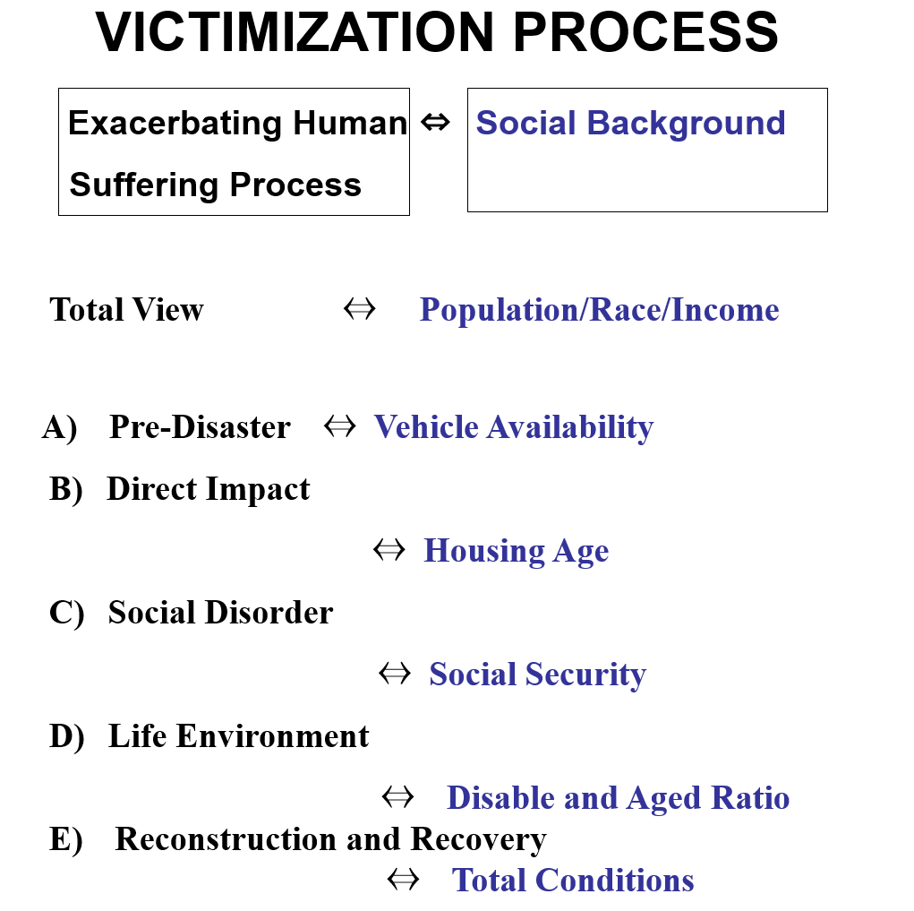
From environmental and sociological perspectives, the difference between the U.S. and Japan is the people’s and nature’s relationships. This case indicated that somehow. The people are living far from nature, on Mt.Helens. That is why the fatality rate was not so high compared to the enormous eruption. In Japan, people tend to live near and with nature. This is called “Satoyama” in Japanese. Other Asian countries are the same as Japan.
This will be discussed later.

Caribbean
Mount Pelee
St.Pierre City was eradicated in 1902 by Mt. Plee’s eruption.
The population of the city was approx. 28000; almost all were dead, only two survived. One of the only two survivors was in prison. The story can be seen in the following video.

2. Climate, meteorological, and hydrological disasters: Hurricanes

North America
In 1900, Galveston’s death toll was over 6,000
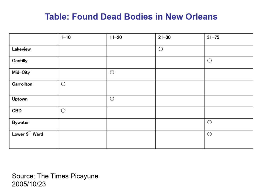
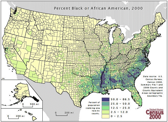
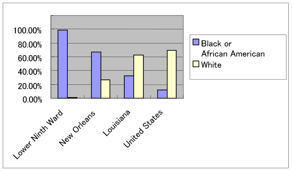
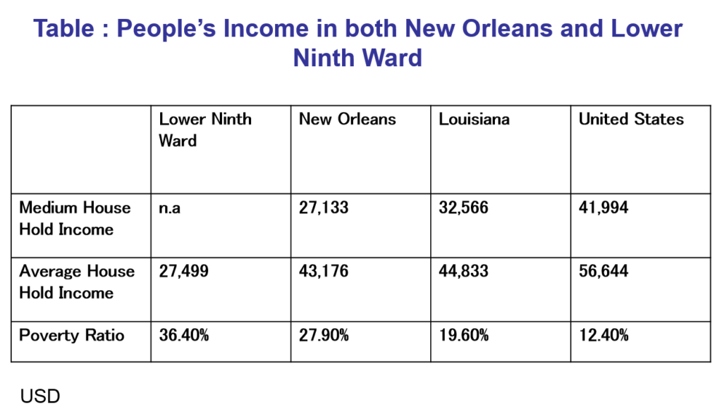
2005 Katrina, the death toll was over 1400, and the cost was $100 billion. UDS
In 1998, Mitch reported that 13,700 people were victimized in Honduras and 3,300 in Nicaragua
Caribbean
Hurricane Jeanne,  2800 were killed in Haiti

Disaster data, such as the death toll, is sourced from the NIED DIL homepage.

Day_162: Disaster Links Library

As mentioned below, the Disaster Links Library has been created. The first draft is attached to this menu as “Disaster Links Library”. There are still many challenges ahead, however, the page will be completed step by step with adding more info.

If you have some excellent links, please let me know.

https://disasterresearchnotes.site/archives/3793

sponsored link

Day_161: Interview Report: Hurricane Katrina Response (2)

>>>>>>>>>>>>>>>>>>>>>>>>>>>>>>>>>
Date and time
7 May 2006
Visit
New Orleans Homeland Security and Public Safety Office
(New Orleans City Office of Homeland Security and Public Safety )

Interviewee
Colonel and Director

Subject
Hurricane Katrina Disaster Response

>>>>>>>>>>>>>>>>>>>>>>>>>>>>>>

https://disasterresearchnotes.site/archives/4059

<Contents>

The following situations were going on to make a decision; one is for the residents who have no means to evacuate and do not have the supply transportation means from the city. The other is for the people who have the means to evacuate but do not do that.

Under these circumstances, a federal rescue bus arrived six days later.

The city ​​has been flooded for two days since the water entered New Orleans. Specifically, the city hall had no water shortly after passing the hurricane, but two days later, it was almost breast-high water level inundation.


Picture: New Orleans City Hall (7 May 2006)

<Current Social Situation>

New Orleans was the only city in the United States to lose its school system, the justice system, home, and tax system. This week, the first trial has been held since last August.

In terms of the school system, only 4 out of 140 schools are open.

The water supply system has lost 80 %.

There is a nuclear power plant near New Orleans. Entergy Corporation is the operating company. However, the company was bankrupted. There are only 10 out of 400 staff members at present.

The natural gas pipeline has been damaged, making gas supply impossible. There are these energy supply problems.

As mentioned, the Entergy Corporation, which is supplying the gas, has been bankrupted, the Entergy Corporation has no support measures from the government.

<New Orleans Society and Geographical Background>

Hurricane Katrina is a human-made disaster. Concerning the background, levees were built in the early 1800s and have worked to prevent annual floods. However, the wetlands had been overlooked. In this area, they dug up the route, so this may cause the storm surge, and also oil drilling reduces the wetlands, weakened resistance to hurricanes.

Katrina disaster is also a national issue. The background of southeastern Louisiana, 40 % of the country’s oil is supplied from here. At the same time, 60 percent natural gas supply of the country is from here. Also, it has 135 chemical and petroleum refineries along the Mississippi River. These are unlikely to create a similar zone in the United States, where environmental pollution becomes a social problem. The Port of New Orleans (New Orleans harbor) can have the giant scale oil tanker in the port. Moreover, the New Orleans area is also a freight rail hub.

To be continued…

Day_160: Interview Report: Hurricane Katrina Response (1)

Now I am digging up my past experience. The report is a part of the project.

The below past article can be checked for your reference.

https://disasterresearchnotes.site/archives/2975

>>>>>>>>>>>>>>>>>>>>>>>>>>>>>>>>>>>>>>>>>>>>>>>>>>>

Date and time
7 May 2006

Visit
New Orleans Homeland Security and Public Safety Office
(New Orleans City Office of Homeland Security and Public Safety )

Interviewee
Colonel and Director

Subject
Hurricane Katrina Disaster Response

>>>>>>>>>>>>>>>>>>>>>>>>>>>>>>>>>>>>>>>>>>>>>>>>>>

<Contents>
< Work >
The interviewee: Responsible for the Police, fire, EMS (emergency medical services),
and crisis management of cooperation with state, federal and city

< The lessons of Katrina >
The lesson learned is, “We can not rely on external resources. Without relying on the federal (country) government, each person should think they need to protect themselves.” (This is the interview record.)

<Hurricane Katrina-What Happened>
Before Friday (8/26), all the state government was setting evacuation preparation. FEMA staff deployed throughout the city. Eighty percent of citizens evacuated on their own, but many of the rest were unable to evacuate with no means.

The city, about 15,000 civilians, were provided transportation means to be saved in the shelter. Besides, before hurricane landfall on Sunday(8/28), the people in the city who can not evacuate evacuated to Super Dome.

Since the federal government does not permit having a shelter in New Orleans, New Orleans is the only city ​​in the U.S. that does not have a shelter. The Federation and the Red Cross had considered the situation as a dangerous task because of this.

When the hurricane comes, Super Dome became a temporary shelter.

Picture: New Orleans City Hall (on 7 May 2006)

After the hurricane, we had a tough week. After all, approximately 700 people of citizens lost their lives.

Day_148: The World Largest Disaster Links

Below is the disaster links site, which was created a long time ago. I will renew this site step-by-step. In addition, some are still only in Japanese, and original disaster-related pictures are omitted, so I will also consider these.

http://disasters.weblike.jp/linklibrary.html

The below disaster-related world organization’s link site is the one that was built when I was working at NIED DIL and is still working as one of the products there. I am very happy to know that, but I would also like to renew this to contribute to the institute with my gratitude in the near future, I hope.

https://dil.bosai.go.jp/link/world/english/index.html

Day_142 : World Disaster Chronology-1994-1995


Date Place Disaster Type Situations
1994.01.17 US, Southeastern Inland Earthquake 1994 Northridge earthquake *
M6.8, 60(D), one of the costliest natural disasters of US history
1994.02.15 Indonesia, West (Sumatra Island) Inland Earthquake M6.6~7.0, Over 200(DM)
1994.05- Bangladesh Cyclone Over 170 (DM)
1994.05.13 Afghanistan Inland Earthquake M6.0, Over160(DM)
1994.06- India / Pakistan Heat Wave Over 400 (D)
1994.06- Ethiopia Drought Over 5,000(D), Food shortage
1994.06- China, Central eastern Heavy Rain, Flood Over 700(DM), A part of Shanghai was inundated
1994.06.02 Indonesia, South (Java Island) Submarine Earthquake M7.8、死不270以上、津波。
1994.06.06 Colombia, South Inland Earthquake M6.6, 300-800(DM), Debris flow
1994.06.09 Bolivia, Peru Deep-focus Earthquake 1994 Bolivia earthquake M8.2 10(D)
1994.07- Rwanda Heat Wave Over 10,000(D), combined with Civil War
1994.08.18 Algeria, North Inland Earthquake M5.7, Over 150(DM)
1994.10.04 Japan, Kunashiri Island Submarine Earthquake The 1994 Hokkaido Toho Oki Earthquake M8.2-8.3, 15(DM), Tsunami
1994.11- India South Cyclone 190(DM)
1994.11.14 The Philippines Inland Earthquake M7.1 Over70(DM) Tsunami
1994.11- Italy Heavy Rain, Flood Over 60(DM)
1994.11- Egypt Lightning 560(DM) Lightning damage to Oil facilities
1994.11- Haiti, Cuba Hurricane, Flood Over 700(DM)
1995.01.17 Japan Inland Earthquake The 1995 Great Hanshin Awaji Earthquake * M6.9~7.3 5,500~6,400(DM)
1995.03- Afghanistan Heavy Rain, Flood, Landslide Over 360(DM)
1995.04- Bangladesh Strong Wind 700(DM)
1995.05.27 Sakhalin, North Inland Earthquake The 1995 Neftegorsk earthquake,M7.1~7.5, Over 1,989(DM) Neftegorsk city was destroyed and vanished from the map after the disaster
1995.05- Brazil Heavy rain, Flood. Landslide Over 80(DM)
1995.05- China Heavy rain, Flood Over 1,100(DM), Yangtze river flood
1995.06- India, Pakistan Heat Wave Over 800(D)
1995.06- Japan Heavy rain, Flood 9(DM), Destroyed Approx.200, Inundated over15,000
1995.07- US Heat Wave Over 800(D)
1995.07- D.P.R.Korea Heavy rain, Flood Over 60(DM)
1995.07- Thailand Heavy rain, Flood Over 200(DM)
1995.08- Morocco Heavy rain, Flood Over 150(DM)
1995.9- The Philippines Heavy rain, Flood Over 540(DM)
1995.11- The Philippines Typhoon, Flood Over 780(DM)
1995.12-  Kazakhstan Cold Wave Over 100(DM) Snowstorm

D: The number of Death M: Missing number DM: The dead and missing number

https://disasterresearchnotes.site/archives/2831

Related articles across the web

Day_103 : New Orleans and Hurricane Katrina in 2005

Day_100 indicated a human suffering exacerbation process in New Orleans during the 2005 Hurricane Katrina.

http://disasters.weblike.jp/disasters/archives/2975

The Figure 1 again shows the relationships between the human suffering exacerbation process and social backgrounds with data. Table 1 also indicates the estimated death numbers in some wards.

exacerbation2
Figure 1 Human Suffering Exacerbation Process and Social Background

Table 1 Found Dead Bodies in New Orleans

dead in neworleans

The total views are indicated in the following Figure 2, 3, 4, and Table 2.
Concerning the population change, New Orleans is the one of the decreasing communities in US. For example, rapid urbanization related matters caused environmental degradation before the disaster. Campanella(2004)mentioned New Orleans became not a sustainable, but a survival city. The lower 9th ward, for example, with regard to the ethnicity, we can see the high black and the African American proportion.  With respect to Income, we can also identify the people living in the Lower 9th ward have lower incomes.

NOLApopulation
Figure 2  Population Change Louisiana( Light Blue ) and New Orleans (Dark Blue)


2000census
Figure 3 Percent Black or African American, 2000 (Census, 2000)

pop and ethnicities
Figure 4 Percent Black or African American and White
(Source: Congressional Research Service)

Table 2 People’s Income in both New Orleans and Lower 9th Ward

income katrina

These are referred by an NIED publication.