Evacuation」カテゴリーアーカイブ

Day_64 : 1985 Nevado del Ruiz Volcano Eruption

One of the most significant volcanic disasters we must know about is the 1985 Nevado del Ruiz volcano eruption. Approx.23000 citizens in Armero city were dead. The cultural aspects were embedded in this disaster. The disaster was predicted. The hazard maps indicate that the city will be affected by a volcanic eruption and lahars. Both priest and mayor told the citizens to stay in the same place because they were afraid of panic before the time, but did not tell them to evacuate. That made tragedy. The people in the city tended to follow both persons because of the culture, which is a religious and vertically structured society. There were also other factors*.


*https://en.wikipedia.org/wiki/Nevado_del_Ruiz#Eruption_and_lahars


Day_207 : Lessons from Hurricane Katrina: A Retrospective Analysis and Future Implications for Disaster Risk Reduction


The picture was taken in Mississippi on December 3, 2005.

Nearly two decades have passed since Hurricane Katrina devastated the Gulf Coast, particularly New Orleans, in 2005. As we reflect on this catastrophic event, it’s crucial to reassess our understanding of the disaster, its impacts, and the lessons learned for future disaster risk reduction efforts. This updated analysis incorporates new research, recent case studies, and current best practices in disaster management to provide a comprehensive view of Hurricane Katrina’s long-lasting effects and implications for disaster preparedness.

Revisiting the Data: The Importance of Pre-Disaster Information

One of the most valuable resources for understanding the pre-Katrina landscape was the Greater New Orleans Community Data Center (GNOCDC) website. This data repository provided detailed demographic and socioeconomic information at the parish and ward levels, offering crucial insights into the social fabric of affected areas.

Key Findings from Pre-Katrina Data

  1. Vehicle Ownership: Data from GNOCDC revealed significant disparities in vehicle ownership across New Orleans neighborhoods. For instance, the Lower 9th Ward, one of the most severely affected areas, had a low rate of vehicle ownership. This factor critically impaired residents’ ability to evacuate independently, necessitating government assistance for evacuation.
  2. Socioeconomic Disparities: Analysis of household incomes, education levels, and employment rates across different wards highlighted pre-existing vulnerabilities that exacerbated the disaster’s impact.
  3. Housing Quality: Information on housing stock age and quality provided insights into structural vulnerabilities that contributed to the extent of physical damage.

The Victimization Process: A Multi-Stage Analysis

Understanding the disaster’s impact requires examining multiple stages of the event and its aftermath. Building on the original five-stage model (Pre-disaster, Direct Damage, Social Disorder, Life Environment, and Reconstruction and Recovery), recent research has emphasized the interconnectedness of these stages and their long-term implications.

Updated Insights on Disaster Stages

  1. Pre-disaster Stage:
    • New research highlights the critical role of community-based preparedness programs in enhancing resilience.
    • Studies show that areas with strong social networks and community engagement had better evacuation rates and post-disaster recovery.
  2. Direct Damage Stage:
    • Advanced modeling techniques have improved our understanding of infrastructure vulnerabilities, particularly in flood-prone areas.
    • Recent case studies from hurricanes like Harvey (2017) and Ida (2021) provide comparative data on immediate impact patterns.
  3. Social Disorder Stage:
    • Long-term studies have revealed the persistent psychological impacts of displacement and community disruption.
    • New frameworks for maintaining social order during disasters emphasize the importance of clear communication and community leadership.
  4. Life Environment Stage:
    • Research on environmental health impacts has expanded, including studies on mold exposure and water contamination.
    • The concept of “build back better” has gained traction, influencing reconstruction efforts to enhance resilience.
  5. Reconstruction and Recovery Stage:
    • Long-term studies show uneven recovery patterns, with some neighborhoods thriving while others continue to struggle.
    • The role of federal, state, and local policies in shaping recovery outcomes has been extensively analyzed, offering lessons for future disaster recovery planning.

Emerging Trends in Disaster Risk Reduction

Since Hurricane Katrina, several key trends have emerged in the field of Disaster Risk Reduction:

  1. Climate Change Adaptation: There’s an increased focus on integrating climate change projections into disaster preparedness and urban planning.
  2. Community-Based Disaster Risk Management: Emphasizing local knowledge and community participation in disaster planning and response.
  3. Technological Advancements: Utilization of GIS, remote sensing, and AI for improved risk assessment and early warning systems.
  4. Social Vulnerability Mapping: More sophisticated tools for identifying and addressing vulnerabilities based on socioeconomic factors.
  5. Nature-Based Solutions: Growing emphasis on using natural ecosystems to mitigate disaster risks, such as wetland restoration for flood control.

Actionable Recommendations

Based on lessons learned from Katrina and subsequent disasters, here are key recommendations for enhancing disaster resilience:

  1. Invest in Inclusive Preparedness: Ensure evacuation plans and resources are accessible to all community members, especially those with limited mobility or resources.
  2. Strengthen Infrastructure Resilience: Implement stricter building codes and invest in critical infrastructure upgrades, particularly in vulnerable areas.
  3. Enhance Early Warning Systems: Develop multi-channel, culturally appropriate warning systems that reach all segments of the population.
  4. Foster Community Cohesion: Support programs that build social capital and community networks, which are crucial for both evacuation and recovery.
  5. Integrate Social Vulnerability in Planning: Use social vulnerability indices to inform resource allocation and targeted support in disaster planning and response.
  6. Promote Sustainable Recovery: Implement recovery strategies that not only rebuild but also address pre-existing social and environmental issues.
  7. Continuous Learning and Adaptation: Establish mechanisms for ongoing assessment and incorporation of lessons learned from each disaster event.

The tragedy of Hurricane Katrina continues to offer valuable lessons for disaster risk reduction. By combining data-driven analysis with a nuanced understanding of social and environmental factors, we can work towards creating more resilient communities. As we face increasing challenges from climate change and urban growth, the insights gained from studying Katrina’s impact remain crucial for shaping effective disaster management strategies worldwide.

Hurricane Katrina Disaster Research conducted by NIED(in Japanese)

A comparative analysis of large-scale flood disasters

Day_157: Disaster Warning (1)

I will update a column of the NIED e-mail magazine I wrote long ago because the content does not fade with time. (I will do this step by step in Japanese and English.) I will also add comments to update the situation.

Sorry, I am now revising this post because of the translation difficulties. This post will be revised again. Thank you.

Published May 6, 2010
NIED-DIL e-mail magazine: Disaster Warning (1)

■ Disaster Warning (1) ■

In February 2008, a survey provided an opportunity to visit Hawaii’s Pacific Tsunami Warning Center (PTWC). In a study, I interviewed the director of the PTWC, and the first thing that caught my attention was the role of the media. The director told me that a public tsunami evacuation alert was required three hours before the event, which was too time-sensitive, but the press was an advantage to do this. However, there were various restrictions for the government organization, such as warnings in an international framework. I remembered the Chilean Navy’s disaster response to the damage caused by the earthquake and tsunami in Chile in February this year.

Next, I was interested in science, technology, and data, which are the basis of alarm decisions. I think regular (flood, etc.) warnings will be judged based on current and past data, but especially for tsunami warnings, there were errors in the original earthquake and the tide gauge data. To judge, we should know that 99.99 percent of the errors could be caused by error. The fact that past data is not very useful because the devices to figure out the data are changing daily, making it difficult to rely on it.

From these facts, it was generally noticed that the disaster warning was based on the combination of the progress of science and technology and the competence of the person in charge. The actual warning also relies on the institution belonging to it. For example, variables such as the recipient of the alert, the psychology of the local people, the social situation, and various systems also needed to be added.

Issued May 6, 2010 No. 4

Day_198 : Characteristics of Earthquake Disasters

In most cases, when a strong earthquake occurs, many people die as buildings collapse. For example, in the Kobe earthquake, more than 90% of the 5,000 people who died lost their lives within 15 minutes immediately after the quake. For this reason, it is essential to build buildings well to reduce the number of people who die in earthquakes. This will prevent fires, make it less likely that people will lose their homes and become permanent refugees, and reduce the problems of relief and rebuilding.

In developing countries, especially in arid and semi-arid regions, earthquakes cause many deaths. In such areas, sun-dried bricks called “adobe” are common building materials, and buildings made of these bricks often collapse easily in earthquakes, burying many people alive. In developing countries, for economic reasons, standards for building earthquake-resistant buildings are usually low, and construction is often inadequate. Therefore, even earthquakes that are not strong can easily cause severe damage. In addition, in regions with many wooden houses, such as Central America and Southeast Asia, buildings can collapse and catch fire.

Day_166: Interview Report: Hurricane Katrina Response (3)

>>>>>>>>>>>>>>>>>>>>>>>>>>>>
Date and time
7 May 2006

Visit
New Orleans Homeland Security and Public Safety Office
(New Orleans City Office of Homeland Security and Public Safety )

Interviewee
Colonel and Director

Subject
Hurricane Katrina Disaster Response
>>>>>>>>>>>>>>>>>>>>>>>>>>>>>>>

https://disasterresearchnotes.site/archives/3002

There are three drainage canals in New Orleans. There is also a pump station for each. Since New Orleans is below sea level, water is constantly pumped from these pump stations and drained into Lake Pontchartrain.

The breakwater was corrupted by the storm surge. The water was flowing into the canal from the lake, and at the same time, the pump station had the maximum pressure with the water. The pumps were broken and became not-functioned.

After the hurricane, there was only one evacuation route that crossed the bridge over Mississippi. However, the route had been blocked. These also affected support activities.

<Measures for breakwater>
At present, the Corps of Engineers will set a lock at the entrance of the canal and close them to prevent water from flowing into the canal since this year.

The challenge from this year is the evacuation of West Bank citizens. Because the levees are weak, hurricanes can easily break them.

The levee can be effective this year, but the problem is that in the next two years, the pump station will have insufficient capacity to pump water.

< Future measures of the city >
The following three goals are set as future measures. First, leave no one in the shelter. Second, the city will assist those who have no access to evacuation. Third, improve the safety of city facilities and property before and after the disaster.

Another important point this year is to let all citizens evacuate two days before Hurricane hit. The challenge is the reality that many people would not try to evacuate. As a background, the levee is to be broken, needs to have a terrible situation imagination.

There is a plan to install floodgates in a wide range of wetlands in eastern New Orleans to prevent storm surges.

Political challenge, New Orleans, including the peripheral has originally 100 million people, was an energy supply base, there is a tremendous national influence, the people here have to work.

As a countermeasure, the city has provided a wireless system. The system had been unavailable after the Hurricane.

A radio station in City Hall as a countermeasure against rumors which had become a social issue during Katrina was set up to keep media members staying and unifying the correct information.

Related information

The NIED team went to New Orleans and Missippi coastal areas to investigate.
Characteristics of the 2005 Hurricane Katrina Disasters

The community data center is the best to investigate to grasp the trend by using stats.

https://disasterresearchnotes.site/archives/2975

Day_161: Interview Report: Hurricane Katrina Response (2)

>>>>>>>>>>>>>>>>>>>>>>>>>>>>>>>>>
Date and time
7 May 2006
Visit
New Orleans Homeland Security and Public Safety Office
(New Orleans City Office of Homeland Security and Public Safety )

Interviewee
Colonel and Director

Subject
Hurricane Katrina Disaster Response

>>>>>>>>>>>>>>>>>>>>>>>>>>>>>>

https://disasterresearchnotes.site/archives/4059

<Contents>

The following situations were going on to make a decision; one is for the residents who have no means to evacuate and do not have the supply transportation means from the city. The other is for the people who have the means to evacuate but do not do that.

Under these circumstances, a federal rescue bus arrived six days later.

The city ​​has been flooded for two days since the water entered New Orleans. Specifically, the city hall had no water shortly after passing the hurricane, but two days later, it was almost breast-high water level inundation.


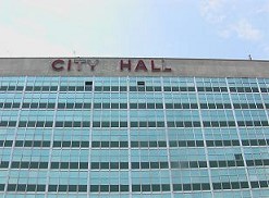
Picture: New Orleans City Hall (7 May 2006)

<Current Social Situation>

New Orleans was the only city in the United States to lose its school system, the justice system, home, and tax system. This week, the first trial has been held since last August.

In terms of the school system, only 4 out of 140 schools are open.

The water supply system has lost 80 %.

There is a nuclear power plant near New Orleans. Entergy Corporation is the operating company. However, the company was bankrupted. There are only 10 out of 400 staff members at present.

The natural gas pipeline has been damaged, making gas supply impossible. There are these energy supply problems.

As mentioned, the Entergy Corporation, which is supplying the gas, has been bankrupted, the Entergy Corporation has no support measures from the government.

<New Orleans Society and Geographical Background>

Hurricane Katrina is a human-made disaster. Concerning the background, levees were built in the early 1800s and have worked to prevent annual floods. However, the wetlands had been overlooked. In this area, they dug up the route, so this may cause the storm surge, and also oil drilling reduces the wetlands, weakened resistance to hurricanes.

Katrina disaster is also a national issue. The background of southeastern Louisiana, 40 % of the country’s oil is supplied from here. At the same time, 60 percent natural gas supply of the country is from here. Also, it has 135 chemical and petroleum refineries along the Mississippi River. These are unlikely to create a similar zone in the United States, where environmental pollution becomes a social problem. The Port of New Orleans (New Orleans harbor) can have the giant scale oil tanker in the port. Moreover, the New Orleans area is also a freight rail hub.

To be continued…

Day_158: Disaster Warning (2)

I will update a column of the NIED e-mail magazine which I wrote a long time ago because the content is not faded with time. (I will do this step by step in Japanese and English) I will also add comments to update the situation.

Sorry, now I am revising this post because of the difficulties of the translation. This post will be revised again. Thank you.

Published June 4, 2010
NIED-DIL e-mail magazine: Disaster Warning (2)

■ Disaster Warning (2) ■

Following the tornado that hit Saroma in Hokkaido in November 2006, I was given the opportunity to visit Oklahoma in the United States in February 2007 for a survey on tornado disaster response, especially tornado disaster alerts. In particular, I visited mainly the NWC (National Weather Center) built inside the University of Oklahoma. At there, Professor Emeritus Yoshikazu Sasaki helped us. He is very famous for being a model of the Hollywood movie “Twister.” I learned that U of Oklahoma, especially a climatological course rapidly became competitive in the U.S. after the movie was released. In the movie “Twister,” there was a scene where cows were flying in the air, at NWC, there was a coffee shop called Flying Cow.

The most impressive thing about the visit was the recognition that the NWC needed a wide range of cooperation on tornado response and put emphasis on community awareness. Regarding multi-disciplinary collaboration, the reason behind this is that even if we increase the accuracy and speed from tornado prediction to warning by science and technology, it will be human beings that will respond to it. Also, there is an organization called the Warning Decision Training Branch (WDTB) <Warning Judgment Training Center> inside the university. The existence is based on the fact that the decision of warning (Warning Decision) is not only radar data, but also specialized in model guidance and mesoscale analysis in combination with the human mind. People, the Emergency Manager, make decisions based on a variety of factors, including technical knowledge and reports from spotters (registered volunteers who inform the situation on the spot). The local factors and political conditions are also overlapped. The knowledge of meteorology expertise alone could not attain the purpose.

As for local enlightenment activities, as a contribution to the community, create and publicize many brochures, open a center, for example, tie-up with McDonald’s in a program called McLeady and give educational advertisements was doing. In this way, the NWC recognizes that disaster alerts are based on various factors such as understanding of human behavior, bonding with society, and political situations, and it is common sense that meteorology alone cannot respond. It was impressive that it was done.

Issued June 4, 2010-Issue 5

https://disasterresearchnotes.site/archives/2553

Day_105 : Relocations or Rebuildings (2)


http://disasters.weblike.jp/disasters/archives/2950

After the 1896 Meiji sanriku tsunami, many communities considered relocating to higher grounds, however, a few communities could proceed the relocations. The main reasons why they could not relocate to higher grounds are the followings (Nakasu et al., 2011):

1) It was very inconvenient for them to settle the areas which were far from the sea because they were mainly fishermen or living their daily lives by the sea.

2) Most of them were doing small size fishing related businesses, had not enough budgets to relocate.

3) There were difficulties to attain the agreements to do relocations among the community members.

4) They, community members, had conflicts with land owners to select and purchase the relocation lands.

5) There were technical limitations to create a land for living on the slope because Japan did not have enough technological level at that time.

They mainly relocated to higher grounds by their own decisions. However, some groups gave pressures on the people who had planned to move and tried to let them give up to do so because they would like to maintain the communities to recover.

A small number of the communities moved to higher grounds, however, some went back to their original places. In addition, their relatives or other village people started to live there. Some families positively accepted the immigrants from outsides to maintain their ownerships.

Finally, almost all communities had chosen to rebuild at the same places, so the risks were retained and this combined with the fact that they were re-affected by the 1933 Showa sanriku tsunami disaster.

Concerning after the 1933 Showa sanriku tsunami, this will be explained later.

Day_90 : (Re)Evacuation research literature analysis-A Text mining

Evacuation’s research literatures are divided into two categories for this analysis. One is natural disaster’s research literature conducted by all specialties. The other is social scientist’s research literature on natural disasters. The database, the Springer link, is selected to conduct all field’s evacuation research literature analysis. The E. L.Quarantelli Resource Collection (See the Website), Disaster Research Center of the University of Delaware was chosen as a target database for analyzing social science literature. The collection is one of the world’s most complete ones on the social and behavioral science aspects of disasters. These two databases’ literatures were analyzed by a text mining. To conduct the text mining, the RH Corder was used.

The following is just one result example, a content analysis of the springer link database.

  1. Search words are “evacuation AND urban AND (tsunami OR flood OR typhoon OR hurricane)”
  2. The number of extracted literature is 824 (2000-2014)
  3. The titles, key words, and abstracts of the 824 were combined into one text file
  4. The extracted words which appear over 20 times in the text are shown in Table1
  5. A co-occurrence network analysis result is indicated in Figure 1

Table 1       Extracted Words (over 20 times) and Frequencies (sorry, original Japanese version’s words are left)

wordsfreq

140715_村上先生_共起ネットワーク2

Figure 1 A co-occurrence network analysis result

In Figure1, the circle sizes around the words (Nodes sizes) mean the frequencies of the words appeared in the text. Edges mean the connections between the words. Then, you can see the above analysis (by color) result.

For instance, emergency response-preparedness-decision-support with “event” are combined with evacuation as key words. Climate-change-impact was also detected with coastal-adaptation. We can estimate that detected Taiwan-assess-community-resilience represents the Typhoon Morakot disaster. (Then, this is confirmed by returning to the original text.)

Murakami et al. (Murakami, Nakasu, Shimamura, Goto, and Ogawa, 2015) is referred.

Day_73 : Altruistic Behaviors

Many disaster cases in Japan indicate some people were victimized to help others.  For example, the following testimony was found in a case of the 1959 Typhoon Isewan disaster (did interviews in 2009):

My father tried to help the neighbor who was drowning and he(my father) was washed away by the water. I and my mother were left”

We also have a traditional legend “Tsunami Tendenko” *in Tohoku, however, it was difficult for local people to follow this during the 2011 Great East Japan Earthquake and Tsunami disaster.

*A traditional legend ”Tsunami Tendenko”
“The ancient “Tsunami Tendenko” tradition means that everybody should run away immediately, without consideration for their families, relatives, or neighbors”

How do you think?

The following is the altruistic behavior model which we can consider.

altruistic behaviors

To know the altruistic behaviors, the below book can be checked.

Altruistic Behavior: A factorial analysis of determinant variables: Altruistic Behavior: is it a function of environmental factors?