Flood」カテゴリーアーカイブ

Day_202 : What is Inland Flooding?

When it rains heavily on a flat area, the rainwater does not drain away and accumulates on the ground. Water flows into low areas from surrounding small elevations. Drainage canals and small rivers are the first to overflow as water levels rise. Floods that occur in this way are called internal floods and are distinguished from external floods that occur when the levees of main rivers break or overflow. In general, internal floods include the overflows of relatively large drainage rivers that have their source in the plain and the overflows of small rivers on plateaus and hillsides into lowlands at the bottom of valleys. Floods caused by internal flooding are particularly problematic in cities and surrounding newly developed urbanized areas. What is called “urban flooding” is the flooding of urban areas, which is intensified by the structure of the city and creates new types of damage, such as the inundation of underground malls.

Day_138 : Natural Disasters in Europe (1)

Natural disasters in Europe mainly consist of hydrological, meteorological, climatological, earthquake and volcano eruption disasters.

europe-pic
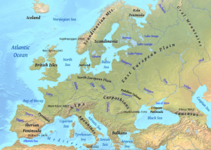
Figure   The Europe

Earthquake disasters mainly occur in the Aegean Sea, the south-western coast of Balkan Peninsula, and the southern part of Italy. Volcanoes are active in the central and southern parts of Italy, the southern Aegean Sea, and Iceland area.

Concerning hydrological, meteorological, and climatological disasters, heavy rain and storm disasters are caused by low  pressure in the Icelandic area developed in the winter season. A cold atmospheric current coming from Arctic gains a warmer vapor stream from the Gulf Stream and develops a strong atmospheric depression in the area. This causes the strong winds and high tidal waves along the coastal areas of the North Sea.

Netherlands and England can be highlighted. The Netherlands had storm surges in 1530 and 1570. The death tolls were approximately 400,000 (1530) and 70,000 (1570) for each. The 1953 depression took an 1800-person death toll. This disaster also reached England. England’s disasters were the 1703 Thames river flood and the 2003 Heatwave. The temperature was 8–10 over the average year in August 2003.

With regard to earthquake disasters, Italy, Greece, and Portugal are the main countries to be affected.

The following past article explains the recent earthquake cases in Italy.

To be continued…

Day_85 : Shingen Embarkment: SAMURAI Disaster Risk Management

Those who can rule the water can also rule the country. This proverb became a reality, especially during the Sengoku period (Warring States Period) in Japan.

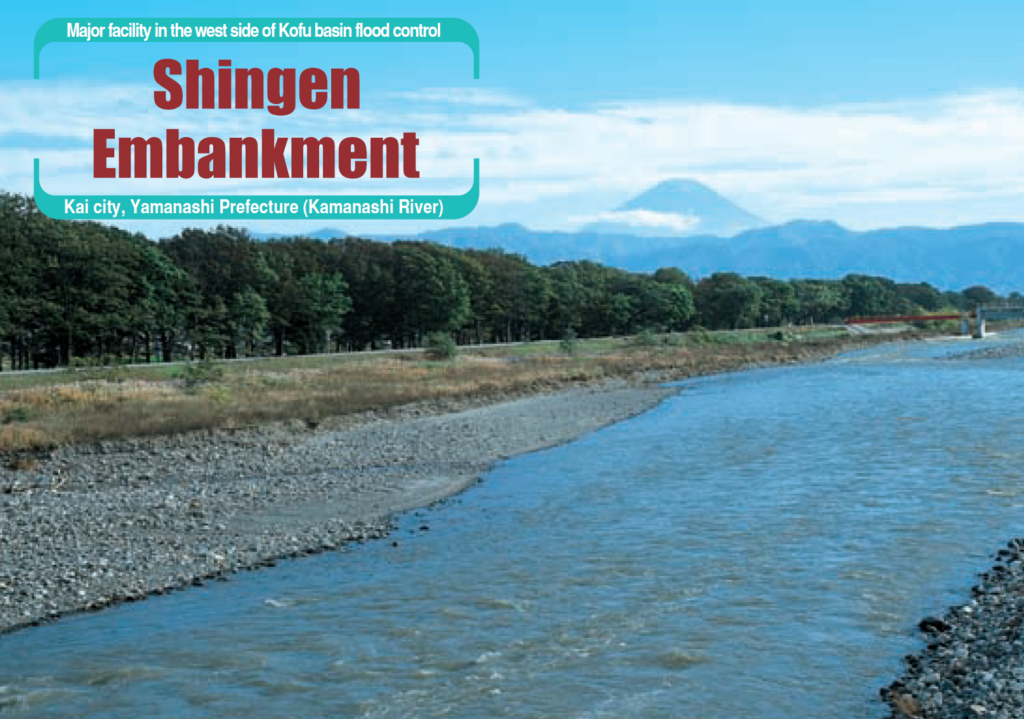
Shingen embankment was a flood control system built over 400 years ago to protect the northern part of the Kofu Basin, the rich rice paddy areas of Kai Province, then under the rule of Daimyo (District Lord) Shingen Takeda. The main problem is that the Midai River, a left branch of the Kamanashi River, is the major branch of the Fuji River, Once the Midai River flow increases and broke the bank protecting the Kofu Basin at its confluence with the Kamanashi River, the flood damage to the paddy fields was extensive. Such floods were known even in prehistoric times. Towards AD 1500, Shingen Takeda, the Daimyo (District Lord) of Kai country, directed that flood control works be made to protect the rice paddy area of his country (Takeuchi, 2003*).

Shingen Takeda was one of the strongest Samurai Daimyo (District Lord). He controlled his soldiers well and so did the floods.

shingenFigure: Shingen Embarkment**

*The Basis of Civilization: Water Science? (Proceedings of theUNESCO/IAMS/IWHA symposium held in Rome, December 2003). AI IS I’ubl. 286, 2004

**Brochure (Information about Fuji river Flood Control)

Day_188: Developing Flood Disaster Preparedness Indices (FDPI) for Thailand

The methodology involves a comprehensive approach to developing Flood Disaster Preparedness Indices (FDPI) for Thailand, with a focus on the cases of Ubon Ratchathani and Hat Yai. The FDPI was developed as a typhoon committee’s project as well as an ICHARM project. The outcome was polished, altered, and customized, and we are using the Indices as a selp capacity assessment tool.

Methodology

The development of Flood Disaster Preparedness Indices (FDPI) in Thailand was driven by a need for a standardized set of indicators that could assess the flood preparedness of local communities comprehensively. The methodology was designed to address the complexities of flood disaster management, acknowledging the balance between structural and non-structural measures (UNISDR, 2015) and the significance of community-based disaster risk management, especially in developing countries (Maskrey, 2011).

Literature Review and Theoretical Framework

An extensive literature review was conducted to understand the existing frameworks and measures used globally for evaluating disaster preparedness, with a particular emphasis on flood disasters. This review helped in identifying gaps in existing indices and provided a theoretical basis for developing a new set of indices that are universally applicable, considering both structural and non-structural elements of disaster risk management (Twigg, 2004; UNISDR, 2009).

Field Surveys and Data Collection

Field surveys were conducted in Bangkok, Ubon Ratchathani Province, and Hat Yai District, including interviews and questionnaire surveys. The surveys aimed to gather first-hand information on local disaster preparedness levels, community awareness, and existing infrastructure. This approach aligns with participatory methods recommended in disaster preparedness research, emphasizing local knowledge and engagement (Gaillard & Mercer, 2013).

Creation of Indices and Diagrams

Based on the literature review and field survey data, a comprehensive set of indices was created. The indices covered various aspects of disaster preparedness, from infrastructure and planning to community awareness and leadership. The creation of these indices was informed by best practices in disaster management literature, including the importance of comprehensive planning, community involvement, and the integration of local and scientific knowledge (Paton & Johnston, 2001; Cutter et al., 2008).

Analysis

The collected data were analyzed using principal component analysis and cluster analysis to identify key components of flood disaster preparedness and to categorize communities based on their preparedness levels. This analytical approach is consistent with methodologies used in similar studies, facilitating the identification of patterns and trends across diverse datasets (Jolliffe & Cadima, 2016).

Validation and Iteration

The FDPI was subjected to several rounds of validation, including expert reviews and community feedback sessions. This iterative process ensured the reliability and applicability of the indices across different communities, addressing the need for flexible and adaptable disaster preparedness tools (Few, 2007).

Source Papers

References:
1. Cutter, S. L., Boruff, B. J., & Shirley, W. L. (2008). Social vulnerability to environmental hazards. Social Science Quarterly, 84(2), 242-261.
2. Few, R. (2007). Health and climatic hazards: Framing social research on vulnerability, response, and adaptation. Global Environmental Change, 17(2), 281-295.
3. Gaillard, J. C., & Mercer, J. (2013). From knowledge to action: Bridging gaps in disaster risk reduction. Progress in Human Geography, 37(1), 93–114.
4. Jolliffe, I. T., & Cadima, J. (2016). Principal component analysis: A review and recent developments. Philosophical Transactions of the Royal Society A: Mathematical, Physical, and Engineering Sciences, 374 (2065), 20150202.
5. Maskrey, A. (2011). Revisiting Community-Based Disaster Risk Management. Environmental Hazards, 10(1), 42–52.
6. Paton, D., & Johnston, D. (2001). Disasters and communities: vulnerability, resilience, and preparedness. Disaster Prevention and Management: An International Journal, 10(4), 270–277.
7. Twigg, J. (2004). Disaster risk reduction: mitigation and preparedness in development and emergency programming. Humanitarian Practice Network.
8. UNISDR (2009). Terminology on Disaster Risk Reduction. United Nations International Strategy for Disaster Reduction.
9. UNISDR (2015). Sendai Framework for Disaster Risk Reduction 2015–2030. United Nations International Strategy for Disaster Reduction.This methodology reflects a comprehensive approach to developing a set of indices that can assess and enhance flood disaster preparedness at the community level. Through a blend of theoretical understanding, field research, and community engagement, the FDPI aims to contribute significantly to disaster risk reduction efforts in Thailand and potentially other similar contexts globally.

Day_175: Exploring Italy’s Struggle with Flooding and Innovative Solutions for a Safe Future Amidst Rising Waters.

Image Source: Unsplash‍

This article is prepared based on the recent flood to understand the flood management status in Italy.

https://www.youtube.com/watch?v=nHgTocw3Ogs

Italy, a country renowned for its captivating aesthetics and profound cultural legacy, confronts a mounting predicament as the water levels surge, jeopardizing its architectural wonders and the routine existence of its populace. The acceleration of climate change has resulted in the nation grappling with the adverse impacts of devastating floods that cause significant damage to its scenic cities and towns. This article delves into the multifaceted challenges posed by floods in Italy, exploring the underlying complexities of the issue and highlighting creative approaches that are transforming the nation’s trajectory. Italy is making strides toward preserving its legacy for future generations by utilizing advanced technology, implementing community-based strategies, and demonstrating an unwavering commitment to environmental sustainability. Embark with us on an enlightening expedition as we delve into the unyielding struggle against the advancing waters and commemorate the achievements of human innovation and resilience in the midst of hardship.

The Impact of Climate Change on Italy’s Flood Risks

The phenomenon of climate change has had a significant impact on the global environment, including Italy. The escalation of global temperatures has resulted in an augmented peril of floods within the nation, which could potentially culminate in disastrous results. The increase in temperature has been found to have a significant impact on the melting of glaciers in the Alps. This phenomenon has been observed to result in a rise in sea levels and an increase in the volume of water in rivers and lakes. The excess of water increases the susceptibility to floods, especially in the coastal regions of Italy that are situated at lower elevations.

Furthermore, the phenomenon of climate change has led to an increase in the frequency and intensity of extreme weather occurrences, including but not limited to heavy precipitation and storms. The occurrence of heavy rainfall can result in the inundation of drainage systems and the emergence of flash floods, which pose a significant threat to urban regions. The impact of climate change on flood risks in Italy is a critical issue that requires comprehensive understanding and innovative solutions to be tackled.

Italy has exhibited a resolute dedication to mitigating its flood hazards, despite the adversities presented by climate change. In recent decades, the nation has made noteworthy progress in comprehending the origins and consequences of floods, while also executing effective measures for prevention and reduction. The forthcoming sections will examine the historical occurrences of floods in Italy, the underlying factors that contribute to its susceptibility to flooding, and the pioneering measures that are shaping a more secure and robust future.

Historical Floods in Italy: Lessons Learned and Progress Made

Italy boasts a rich historical record of disastrous floods that have inflicted enduring damage upon its terrain and populace. In 1966, the Arno River in Florence experienced a catastrophic flood that resulted in the loss of over 100 lives and extensive damage to numerous works of art and cultural artifacts. This event has become widely recognized as one of the most infamous floods in history. The aforementioned calamitous incident acted as a stimulus for the country and instigated a revitalized emphasis on flood prevention and readiness.

Subsequent to the Florence flood, Italy encountered a multitude of consequential flood occurrences. The Piedmont region experienced a catastrophic flood in 1994, resulting in extensive devastation and loss of human lives. In 2011, Genoa experienced a flash flood that resulted in the loss of six lives and significant harm to infrastructure. The aforementioned calamitous incidents have underscored the necessity for effective flood management strategies, prompting the Italian authorities to allocate resources towards scholarly inquiry, enhancements in infrastructure, and pioneering approaches aimed at mitigating the hazards associated with flooding.

Italy has achieved significant advancements in comprehending its flood hazards and executing strategies to avert and reduce their consequences, owing to these endeavors. The nation has implemented advanced flood forecasting and early warning mechanisms to furnish prior intimation of potential flood incidents, thereby empowering communities to make adequate preparations and respond with greater efficacy. Moreover, Italy has made significant investments in enhancing its infrastructure, including the development of dams, levees, and drainage systems, with the aim of providing greater protection to regions that are susceptible to flooding. Despite notable advancements, there remains a substantial amount of work to be undertaken in order to guarantee the safety and fortitude of Italy’s populace in light of the escalating threat of flooding.

Factors Contributing to Italy’s Flood Vulnerability

Italy’s susceptibility to floods can be attributed to a combination of factors, such as its distinctive geography, urbanization, and land-use practices. The nation’s vast expanse of coastal areas and multiple waterways provide it especially vulnerable to inundation caused by both coastal storms and riverine deluges. Furthermore, the topography of Italy is distinguished by steep mountainous regions and narrow valleys, which can intensify the probability of flooding by directing water towards densely inhabited regions and enhancing the possibility of landslides.

The surge in urbanization and alterations in land use has been instrumental in enhancing Italy’s susceptibility to flooding. The expansion of urban areas results in the replacement of natural landscapes with impervious surfaces, such as buildings, roads, and parking lots, that hinder the infiltration of water into the ground. Consequently, there is a rise in surface runoff and an enhanced susceptibility to flooding in the occurrence of intense precipitation episodes. Moreover, the development of infrastructure in regions susceptible to flooding has increased the vulnerability of both individuals and resources, thereby exacerbating the potential consequences of a flood occurrence.

Italy’s susceptibility to floods can also be attributed to insufficient maintenance of flood defense infrastructure, including levees, dams, and drainage systems. Insufficient investment in maintenance and aging infrastructure can result in the failure of crucial systems during critical times, thereby endangering lives and property. It is imperative to consider these factors in order to mitigate flood hazards in Italy and establish a future that is more resilient.

Innovative Flood Management Solutions in Italy

Italy has adopted a multifaceted approach to address the intricate issues posed by flooding, which integrates conventional flood protection strategies with state-of-the-art technology and environmentally conscious methodologies. The proposed solutions endeavor to mitigate the underlying factors that contribute to susceptibility to flooding, while simultaneously advocating for ecological sustainability and adaptability.

The implementation of green infrastructure within urban environments represents a viable strategy. Green infrastructure applies to the utilization of natural or semi-natural mechanisms, such as green roofs, parks, and permeable pavements, for the purpose of effectively handling stormwater and mitigating the likelihood of flooding. The aforementioned characteristics not only facilitate the assimilation and absorption of surplus water but also result in dramatic ecological and communal advantages, including reduced atmospheric conditions, diminished urban heat island consequences, and enhanced biodiversity.

An additional inventive approach involves the adoption of flexible and adaptable flood control tactics that can adapt to fluctuating circumstances and ambiguities. The MOSE project, a system of mobile barriers, has been developed by the city of Venice to safeguard the city from the negative impacts of rising sea levels and storm surges. The barriers possess the capacity to be adjusted in accordance with the varying flood risks, thereby facilitating a flexible approach while mitigating the adverse effects on the city’s fragile ecosystem and heritage edifices.

Urban Planning and Design for Flood Resilience

Apart from pioneering flood management strategies, Italy has acknowledged the significance of urban planning and design in advancing flood resilience. The incorporation of flood risk assessments into the planning and development process can enhance the resilience of urban and rural areas to floods and facilitate their adaptation to the dynamic climate.

The identification and preservation of natural floodplains is a crucial element in urban planning strategies aimed at enhancing flood resilience. The aforementioned regions, which exhibit susceptibility to inundation in the event of heavy precipitation, play a pivotal role in affording storage and absorption capacity for surplus water. Through the preservation of these regions and the imposition of development restrictions within them, communities can mitigate their exposure to flood hazards while simultaneously safeguarding crucial ecosystem services and habitats for wildlife.

Another important consideration is the integration of flood risk management into the design of buildings and infrastructure. Potential strategies for mitigating flood risks may involve implementing techniques such as raising structures to exceed projected flood levels, utilizing materials and construction methods that are resistant to flooding, and creating adaptable spaces that can serve a variety of purposes, such as temporary flood storage or evacuation facilities. Through the integration of these design principles, communities have the ability to mitigate the potential adverse impacts and disturbances resulting from flooding while simultaneously strengthening their overall capacity for resilience.

The Role of Nature-Based Solutions in Flood Mitigation

In contemporary times, there has been a growing interest in nature-based solutions (NBS) as a practical and economical strategy for mitigating floods. The aforementioned solutions utilize natural processes and ecosystems to mitigate flood hazards through restoration, preservation, or enhancement. Instances of Nature-Based Solutions (NBS) encompass the rehabilitation of wetlands and floodplains, afforestation of slopes, and establishment of green areas in urban settings.

Several NBS (Nature-Based Solutions) initiatives have been successfully executed in Italy, exhibiting encouraging outcomes. The “Life-Envi-Med” initiative, located in the Sardinia region, aims to mitigate flood hazards and foster biodiversity by rehabilitating and safeguarding coastal dunes and wetlands. An additional instance is the “Vallevecchia” initiative located in the Veneto region, with the objective of rehabilitating prior farmland to establish a natural barrier area that can assimilate floodwaters and offer significant habitat for fauna.

Through the implementation of Nature-Based Solutions (NBS), Italy is able to mitigate the potential hazards of flooding while simultaneously demonstrating its dedication to the principles of ecological sustainability and the preservation of biodiversity. Moreover, Natural Based Solutions (NBS) frequently offer supplementary advantages, such as improved water quality, heightened recreational possibilities, and enhanced climate change adaptability, rendering them a valuable constituent of Italy’s comprehensive flood management approach.

Technological Advancements in Flood Forecasting and Early Warning Systems

The utilization of technology is of utmost importance in Italy’s endeavors to effectively mitigate flood hazards and strengthen its capacity to adapt to adverse circumstances. The implementation of flood forecasting and early warning systems has played a crucial role in mitigating the adverse effects of floods on both human settlements and physical infrastructure.

The National Early Warning System for Hydrogeological and Hydraulic Risks (SINIFF) is a noteworthy instance of technological advancement, which was established through a joint venture between the National Civil Protection Department of Italy and the regional environmental protection agencies. SINIFF integrates contemporaneous data from monitoring stations with sophisticated hydrological and meteorological models to furnish prompt and precise flood prognostications and notifications. The aforementioned data empowers regional governing bodies and first responders to adopt preemptive measures aimed at safeguarding human lives and assets, including but not limited to the evacuation of inhabitants, road closures, and fortification of flood barriers.

Apart from SINIFF, various early warning systems at regional and local levels have been formulated to cater to distinct flood hazards and susceptibilities. The Piedmont region has incorporated a sophisticated flood prediction system that integrates current information from river monitoring stations, weather radar data, and hydrological models to predict potential flood occurrences. Through the utilization of technological advancements, Italy can enhance its ability to forecast and address flood hazards, leading to a reduction in the adverse impact on both human life and economic resources caused by such disasters.

Community Engagement and Collaboration in Italy’s Flood Management

Effectively addressing the complex problems related to flood management necessitates the involvement and cooperation of various entities, such as government agencies, scholars, enterprises, and nearby populations. Italy has adopted a participatory strategy for flood management, prioritizing the involvement of all pertinent stakeholders in the decision-making process and promoting a collective sense of accountability for mitigating flood risks.

An instance of community involvement in flood management is the formation of regional flood committees, which convene delegates from diverse sectors to formulate and execute strategies for managing flood risks. The aforementioned committees serve as a platform for various stakeholders to exchange information, collaborate on initiatives, and devise novel approaches to address flood-related issues at the local level.

Additionally, Italy has acknowledged the significance of public education and awareness in advancing flood resilience. The National Flood Awareness Campaign is an endeavor that seeks to disseminate knowledge and provide instruction to individuals regarding the hazards of flooding and the actions they can undertake to safeguard themselves and their localities. Italy is fostering a culture of resilience and enhancing its capacity to adapt to the evolving climate by equipping individuals and communities with knowledge and skills.

The implementation of collaborative efforts and partnerships is deemed essential in Italy’s flood management endeavors. The nation has forged collaborations with global organizations, such as the European Union, to exchange knowledge and proficiency and acquire financial resources for inundation control initiatives. Furthermore, Italy has engaged in cooperative efforts with its adjacent nations, including France and Switzerland, to tackle the issue of cross-border flood hazards and establish collective flood control strategies.

It is imperative that Italy takes measures to enhance its flood management capabilities to safeguard its future.

The current situation in Italy highlights the necessity for a holistic and cohesive strategy toward flood control and mitigation. Italy can enhance its flood risk mitigation strategies by integrating traditional flood defense measures with innovative methods such as green infrastructure, adaptive flood management, and nature-based solutions, thereby fostering ecological sustainability and resilience.

In addition, it is imperative that Italy involves all pertinent parties such as governmental entities, scholars, enterprises, and nearby communities in the process of making decisions and cultivates a mindset of fortitude and cooperation. Through collaborative efforts, Italy has the potential to construct a more secure and durable future for its populace while safeguarding its cultural legacy for future generations.

Italy’s ability to overcome challenges related to climate change and flooding is noteworthy, given its history of resilience and innovation, which serves as a source of inspiration and optimism. Italy is able to overcome these challenges and establish a more sustainable future by persisting in its investment in flood management strategies and adopting innovative ideas and technologies.

Day_169: The 2011 Chao Phraya River Flood Literature Reviews

Regarding the published literature, there are several approaches to investigate the 2011 flood.
Mark and Lebel (Mark and Lebel, 2016) describe how Thailand’s incomplete decentralization and administrative fragmentation has created numerous barriers to polycentric disaster governance.

Hagiwara et al. (2014) explained the chain reactions of the economic damage mainly derived from the experience of Japanese enterprises and points out issues that disrupted their businesses. That paper focused on the risk management changes of the firms after the 2011 flood, indicating they have strengthened their flood countermeasures as a whole, but points to the need to consider more about the collaborations with business partners or other entities.

Okazumi and Nakasu (2013) (2015) examined the devastating exacerbation of economic damage through a social background perspective and enterprise inter-relationships.

Nakasu (2017) clarified the reasons why so many Japanese companies moved to the potential risk area in Thailand. The reasons are from the perspective of both the country’s social factors through decentralization policies facilitated by the Thai government and also yen appreciation triggered by the Plaza agreement (1985) and the Lehman Brother’s bankruptcy (2008) to propel Japanese enterprise relocation and advancement.

Haraguch and L. Upmanu (2015) emphasized the decision-making process of enterprises to clarify the trigger of economic damage. That paper proposed measures for related supply chain risk through setting research questions such as private investment decision-making, the diversified sources of procurement, emergent assistance from other partner companies in the same supply chain, and the degree of the recovery of customers.

Tamada et al. (2013) approached the subject mainly from economic, political, hydrological, and technological perspectives with various authors. That book clarified the complexity of the 2011 flood and overviewed how human interventions affect the disaster, such as local people’s lifestyle changes before the disaster, the establishment of the industrial complexes in the area, government agency conflicts, dam operation impacts, unexpected rainfall, and private company reactions.

Singkran (2017) reviewed the 2011 flood from disaster management views and emphasized the need for more non-structural countermeasures and participatory collaboration among stakeholders for effective disaster management.

Reference
Hagiwara, Y, Kuribayashi, D, Okazumi, T, Nakasu, T. (2014). Characteristics of the Chain-Reaction Damage of the Japanese Firms Affected by the 2011 Thai Flood, Advances in River Engineering Vol.20, pp.397 – 402(in Japanese)


Haraguchi, M and Upmanu, L. (2015). Flood risks and impacts: A Case Study of Thailand’s Floods in 2011 and Research Questions for Supply Chain Decision Making, International Journal of Disaster Risk  Reduction, 14:256-272.


Japanese Chamber of Commerce, Bangkok. (2012). 2011 Economic Overview of Thailand(2011/2012). Japanese Chamber of Commerce, Bangkok.

Japan Science and Technology Agency (JST). (2019). Regional Resilience Enhancement through Establishment of Area-BCM at Industry Complexes in Thailand: Enhance regional resilience through visualization of disaster risks with industry, government and academia collaboration. SATREPS (Science and Technology Research Partnership for Sustainable Development) Project https://www.jst.go.jp/global/english/kadai/h2908_thailand.html accessed March 20, 2019

JETRO. (2012). Special Topics: Information on Thai Flood Disaster Recovery, Tokyo (in Japanese). http://www.jetro.go.jp/world/asia/th/flood/ accessed June 20, 2012.

Marks D and Lebel L. (2016). Disaster governance and the scalar politics of incomplete decentralization: fragmented and contested responses to the 2011 floods in Central Thailand. Habitat Int Decentralizing Disaster Gov Spec Issue 52:57–66.

Marks, D. (2019). Assembling the 2011 Thailand floods: Protecting farmers and inundating high-value industrial estates in a fragmented hydro-social territory. Political Geography, 68, 66-76.

Nakasu, T, Okazumi, T. and Shimizu, Y. (2013). Establishment of Industrial Areas and New Risk Management: Chain Reactions of Economic Damage caused by 2011 Thailand Chao Phraya River Flood Disasters and Local Societies. The Journal of Urban Social Studies,No.5, 2013, 159-169.

Nakasu, T. (2017). Natural Disasters and Disaster Management in Thailand: Status, Risks, and Trends.13th International Conference on Thai Studies.

Office of the National Economic and Social Development Boad (NESDB). (2016). The National Economic and Social Development Plan.Retrieved May 4, 2017.

Okazumi, T. and Nakasu, T. (2015). Lessons learned from two unprecedented disasters in 2011–Great East Japan Earthquake and Tsunami in Japan and Chao Phraya River flood in Thailand. International journal of disaster risk reduction, 13, 200-206.

Singkran, N. (2017). Flood risk management in Thailand: Shifting from a passive to a progressive paradigm. International journal of disaster risk reduction, 25, 92-100.

Sukekawa, S.(2013). Impacts on Industries and Enterprises Caused by the Thai 2011 Great Flood. In Thai 2011 Great Flood. Chiba: IDE-JETRO. (in Japanese)

Tamada, Y.Hoshikawa, K. Funatsu, T. ed. (2013). The 2011 Great Flood: Records and Lessons. In Thai 2011 Great Flood. Chiba: IDE-JETRO(in Japanese).

Tokyo Marine & Nichido Fire Insurance Co.,Ltd.(2011). Lessons Learned from the 2011 Thailand Flood Disaster: Points of flood risk countermeasures in overseas bases.

Day_166: Interview Report: Hurricane Katrina Response (3)

>>>>>>>>>>>>>>>>>>>>>>>>>>>>
Date and time
7 May 2006

Visit
New Orleans Homeland Security and Public Safety Office
(New Orleans City Office of Homeland Security and Public Safety )

Interviewee
Colonel and Director

Subject
Hurricane Katrina Disaster Response
>>>>>>>>>>>>>>>>>>>>>>>>>>>>>>>

https://disasterresearchnotes.site/archives/3002

There are three drainage canals in New Orleans. There is also a pump station for each. Since New Orleans is below sea level, water is constantly pumped from these pump stations and drained into Lake Pontchartrain.

The breakwater was corrupted by the storm surge. The water was flowing into the canal from the lake, and at the same time, the pump station had the maximum pressure with the water. The pumps were broken and became not-functioned.

After the hurricane, there was only one evacuation route that crossed the bridge over Mississippi. However, the route had been blocked. These also affected support activities.

<Measures for breakwater>
At present, the Corps of Engineers will set a lock at the entrance of the canal and close them to prevent water from flowing into the canal since this year.

The challenge from this year is the evacuation of West Bank citizens. Because the levees are weak, hurricanes can easily break them.

The levee can be effective this year, but the problem is that in the next two years, the pump station will have insufficient capacity to pump water.

< Future measures of the city >
The following three goals are set as future measures. First, leave no one in the shelter. Second, the city will assist those who have no access to evacuation. Third, improve the safety of city facilities and property before and after the disaster.

Another important point this year is to let all citizens evacuate two days before Hurricane hit. The challenge is the reality that many people would not try to evacuate. As a background, the levee is to be broken, needs to have a terrible situation imagination.

There is a plan to install floodgates in a wide range of wetlands in eastern New Orleans to prevent storm surges.

Political challenge, New Orleans, including the peripheral has originally 100 million people, was an energy supply base, there is a tremendous national influence, the people here have to work.

As a countermeasure, the city has provided a wireless system. The system had been unavailable after the Hurricane.

A radio station in City Hall as a countermeasure against rumors which had become a social issue during Katrina was set up to keep media members staying and unifying the correct information.

Related information

The NIED team went to New Orleans and Missippi coastal areas to investigate.
Characteristics of the 2005 Hurricane Katrina Disasters

The community data center is the best to investigate to grasp the trend by using stats.

https://disasterresearchnotes.site/archives/2975

Day_161: Interview Report: Hurricane Katrina Response (2)

>>>>>>>>>>>>>>>>>>>>>>>>>>>>>>>>>
Date and time
7 May 2006
Visit
New Orleans Homeland Security and Public Safety Office
(New Orleans City Office of Homeland Security and Public Safety )

Interviewee
Colonel and Director

Subject
Hurricane Katrina Disaster Response

>>>>>>>>>>>>>>>>>>>>>>>>>>>>>>

https://disasterresearchnotes.site/archives/4059

<Contents>

The following situations were going on to make a decision; one is for the residents who have no means to evacuate and do not have the supply transportation means from the city. The other is for the people who have the means to evacuate but do not do that.

Under these circumstances, a federal rescue bus arrived six days later.

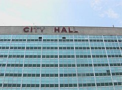
The city ​​has been flooded for two days since the water entered New Orleans. Specifically, the city hall had no water shortly after passing the hurricane, but two days later, it was almost breast-high water level inundation.


Picture: New Orleans City Hall (7 May 2006)

<Current Social Situation>

New Orleans was the only city in the United States to lose its school system, the justice system, home, and tax system. This week, the first trial has been held since last August.

In terms of the school system, only 4 out of 140 schools are open.

The water supply system has lost 80 %.

There is a nuclear power plant near New Orleans. Entergy Corporation is the operating company. However, the company was bankrupted. There are only 10 out of 400 staff members at present.

The natural gas pipeline has been damaged, making gas supply impossible. There are these energy supply problems.

As mentioned, the Entergy Corporation, which is supplying the gas, has been bankrupted, the Entergy Corporation has no support measures from the government.

<New Orleans Society and Geographical Background>

Hurricane Katrina is a human-made disaster. Concerning the background, levees were built in the early 1800s and have worked to prevent annual floods. However, the wetlands had been overlooked. In this area, they dug up the route, so this may cause the storm surge, and also oil drilling reduces the wetlands, weakened resistance to hurricanes.

Katrina disaster is also a national issue. The background of southeastern Louisiana, 40 % of the country’s oil is supplied from here. At the same time, 60 percent natural gas supply of the country is from here. Also, it has 135 chemical and petroleum refineries along the Mississippi River. These are unlikely to create a similar zone in the United States, where environmental pollution becomes a social problem. The Port of New Orleans (New Orleans harbor) can have the giant scale oil tanker in the port. Moreover, the New Orleans area is also a freight rail hub.

To be continued…

Day_149: Flood Disaster Preparedness Indices (FDPI)

ICHARM (International Centre for Water Hazard and Risk Management) allowed me to engage in the project on the development of Flood Disaster Preparedness Indices (FDPI). This project is also linked to one of the projects of the Typhoon Committee (World Meteorological Organization/United Nations ESCAP).

You can see the outline of the project on the following website:.

http://www.apan-gan.net/adaptation-technologies/database/flood-disaster-preparedness-indices-fdpi

The established site is the self-evaluation system for local disaster managers around the world, especially in developing countries. Therefore, we have prepared the multi-language (16 languages) versions. You can evaluate your community’s preparedness ability by yourself, and experience can also be shared depending on your situation.  You can easily see your results on the website. The results are automatically sent to the administrator to check on the situation. If the administrator understands the severity, he or she can communicate with the international aid agencies.

http://www.fdpi.jp/fdpi/

To be continued…

Day_145: Past Columns (in Japanese)

Past columns will be updated both in Japanese and English.

My past Japanese writings for an internet newspaper company and the research map researcher’s blog (Japan Science and Technology Agency’s site) can be checked in the following, but the article of the news company is not free and is not in English or Japanese.

http://www.nikkanberita.com/index.cgi?cat=writer&id=200507100351580

https://researchmap.jp/read0139271/%E7%A0%94%E7%A9%B6%E3%83%96%E3%83%AD%E3%82%B0/