Author Archives: tada

About tada

Dr. Nakasu is a post-doctoral fellow and an adjunct lecturer at College of Population Studies, Chulalongkorn University in Thailand. He had been working at NIED (National Research Institute for Earth Science and Disaster Prevention) as a principal research fellow and ICHARM (International Centre for Water Hazard and Risk Management), PWRI (Public Works Research Institute) as a research specialist in Japan for a decade. He has conducted many disaster field surveys such as Indian Ocean Tsunami (2004), Hurricane Katrina (2005), Typhoon Ondoy and Pepeng (2009), Great East Japan Earthquake and Tsunami (2011), and Chao Phraya River Flood (2011). He also conducted abundant disaster management research around the globe. He had been a project leader of the Working Group of Hydrology, the Typhoon Committee (WMO and UN/ESCAP) for nearly 3 years. He was also a visiting researcher at JICA (Japan International Cooperation Agency) and an adjunct instructor at several universities in Japan. He won a second prize for his poster presentation at the Society for Risk Analysis-Asia Conference in Taipei in 2014. He is a tsunami evacuation research committee member of the Japanese Association for Earthquake Engineering (JAEE). His research interests include the environment and comparative studies. 日本語版: 中須正

【Disaster Research】When Nature Meets Human Error: Lessons from History’s Deadliest Volcanic Mudflow 40 Years Ago

Growing up, many of us were taught that natural disasters are inevitable acts of nature beyond human control. This perspective changed dramatically for me when I started working at a research institute. My senior researcher emphatically told me, “The natural disaster is not natural.” This profound statement transformed my approach to disaster research, helping me understand that human decisions often determine whether natural hazards become catastrophic disasters.

The Forgotten Tragedy of Armero

On November 13, 1985, the Nevado del Ruiz volcano in Colombia erupted after 69 years of dormancy. The eruption triggered massive mudflows (lahars) that rushed down the volcano’s slopes, burying the town of Armero and claiming over 23,000 lives. This catastrophe stands as Colombia’s worst natural hazard-induced disaster and the deadliest lahar ever recorded.

What makes this tragedy particularly heartbreaking is its preventability. Scientists had observed warning signs for months, with seismic activity beginning as early as November 1984. By March 1985, a UN seismologist had observed a 150-meter vapor column erupting from the mountain and concluded that a major eruption was likely.

Despite these warnings, effective action to protect the vulnerable population never materialized. The devastation of Armero wasn’t simply the result of volcanic activity but the culmination of multiple human failures in risk communication, historical memory, and emergency response.

When Warning Systems Fail: Communication Breakdown

The Armero disaster epitomizes what disaster researchers call “cascading failures” in warning systems. Scientists had created hazard maps showing the potential danger to Armero in October 1985, just weeks before the eruption. However, these maps suffered from critical design flaws that rendered them ineffective.

One version lacked a clear legend to interpret the colored zones, making it incomprehensible to the general public. Devastatingly, Armero was placed within a green zone on some maps, which many residents misinterpreted as indicating safety rather than danger. According to reports, many survivors later recounted they had never even heard of the hazard maps before the eruption, despite their publication in several major newspapers.

As a disaster researcher, I’ve seen this pattern repeatedly: scientific knowledge fails to translate into public understanding and action. When I conducted fieldwork in flood-prone regions in Thailand, I discovered a similar disconnect between technical risk assessments and public perception. Effective disaster mitigation requires not just accurate information but information that is accessible and actionable for those at risk.

The Cultural Blindspots of Risk Perception

The tragedy of Armero illustrates how cultural and historical factors shape how communities perceive risk. Despite previous eruptions destroying the town in 1595 and 1845, causing approximately 636 and 1,000 deaths respectively, collective memory of these disasters had seemingly faded as the town was rebuilt in the same location.

In the hours before the disaster, when ash began falling around 3:00 PM, local leaders, including the town priest, reportedly advised people to “stay calm” and remain indoors. Some residents recall a priest encouraging them to “enjoy this beautiful show” of ashfall, suggesting it was harmless. These reassurances from trusted community figures likely discouraged self-evacuation that might have saved lives.

My research in disaster-prone communities has consistently shown that risk perception is heavily influenced by cultural factors, including trust in authority figures and historical experience with hazards. In Japan, for instance, the tsunami markers that indicate historic high-water levels serve as constant physical reminders of past disasters, helping to maintain community awareness across generations.

Systemic Failures and Institutional Response

The Armero tragedy wasn’t just a failure of risk communication or cultural blind spots—it revealed systemic weaknesses in disaster governance. Colombia was grappling with significant political instability due to years of civil war, potentially diverting governmental resources from disaster preparedness. Just a week before the eruption, the government was heavily focused on a guerrilla siege at the Palace of Justice in Bogotá.

Reports suggest there was reluctance on the part of the government to bear the potential economic and political repercussions of ordering an evacuation that might have proven unnecessary. This hesitation proved fatal when communication systems failed on the night of the eruption due to a severe storm, preventing warnings from reaching residents even after the lahars were already descending toward the town.

In my research examining large-scale flood disasters, I’ve found that effective disaster governance requires robust institutions that prioritize public safety over short-term economic or political considerations. My 2021 comparative analysis of major flood events demonstrated that preemptive protective actions consistently save more lives than reactive emergency responses, even when accounting for false alarms.

Learning from Tragedy: The Path Forward

The Armero disaster, while devastating, catalyzed significant advancements in volcano monitoring and disaster risk reduction globally. Colombia established specialized disaster management agencies with greater emphasis on proactive preparedness. The

Colombian Geological Service expanded from limited capacity to a network of 600 stations monitoring 23 active volcanoes.

The contrast with the 1991 eruption of Mount Pinatubo in the Philippines demonstrates the impact of these lessons. There, timely forecasts and effective evacuation procedures saved thousands of lives. The memory of Armero remains a powerful reminder of the consequences of inadequate disaster preparedness.

As I’ve emphasized in my own research on disaster resilience in industrial complex areas, building sustainable communities requires integrating technical knowledge with social systems. My work developing social vulnerability indices demonstrates that effective disaster risk reduction must address both physical hazards and social vulnerabilities.

Remember, disasters may be triggered by natural events, but their impact is determined by human decisions. By learning from tragedies like Armero, we can create more resilient communities prepared to face future challenges.

【Disaster Research】ADRC: Kobe’s Legacy in Asian Disaster Risk Reduction

From Tragedy to Leadership: The Birth of ADRC

The Asian Disaster Reduction Center (ADRC) was established in 1998 following the devastating Great Hanshin-Awaji Earthquake (commonly known as the Kobe Earthquake) that struck Japan in 1995. This catastrophic event became a catalyst for change, transforming how Japan—and later Asia—approached disaster management and resilience.

Kobe’s Remarkable Recovery Journey

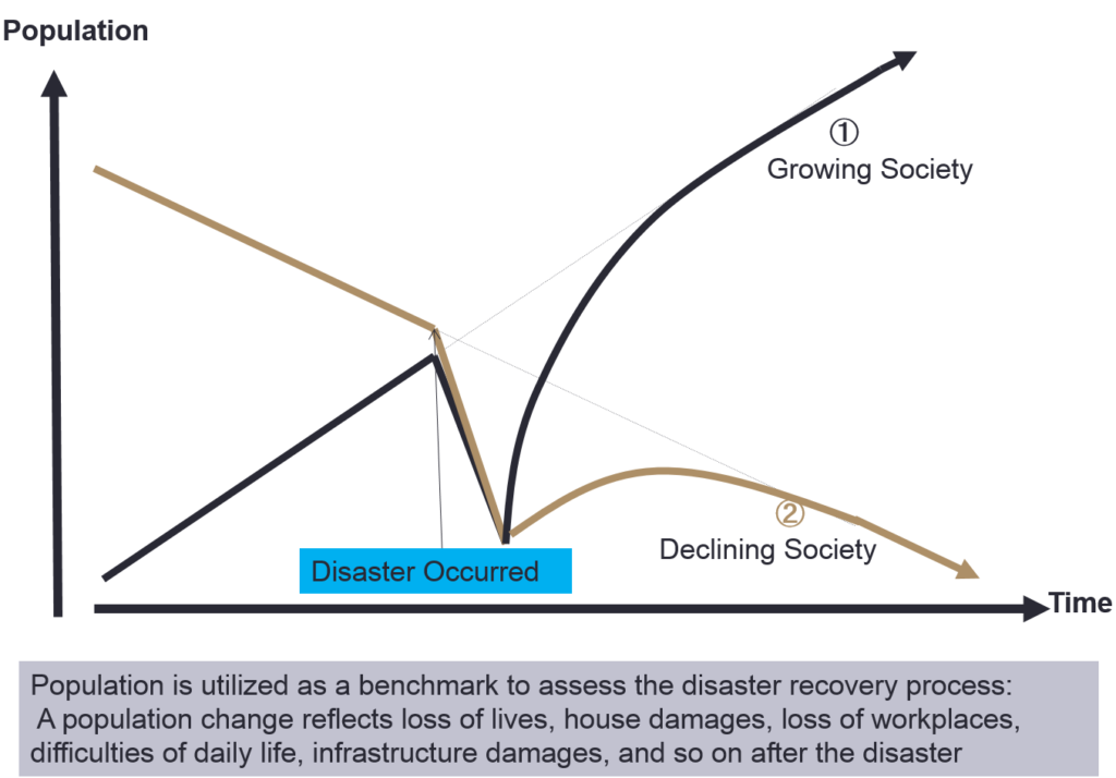
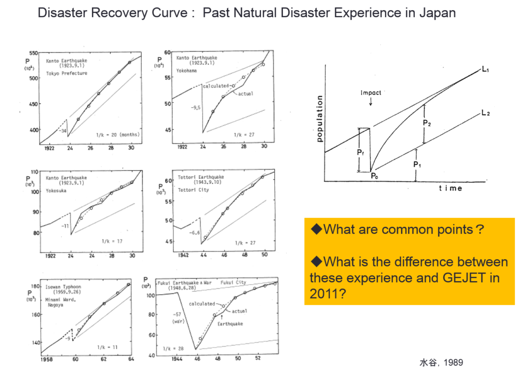
Kobe’s recovery story stands as a powerful testament to resilience and strategic rebuilding. Within just 9 years after the earthquake, Kobe’s population returned to pre-disaster levels—an extraordinary achievement considering the scale of destruction. This recovery wasn’t merely about rebuilding structures but reimagining the city’s future role.

HAT Kobe: A Hub for Disaster Reduction Excellence

Today, Kobe has reinvented itself as a global center for disaster reduction policies and activities. The area known as HAT Kobe hosts numerous disaster-related organizations, including ADRC. The name “HAT” carries dual significance:

  • It stands for “Happy and Active Town”
  • In Japanese, “hatto” (ハッと) means “surprised” or “sudden realization”

This wordplay perfectly captures Kobe’s transformation from a disaster-struck city to a knowledge hub that helps others prepare for and respond to unexpected disasters.

Learning From Kobe: A Model for Disaster Recovery

Kobe’s recovery process offers valuable lessons for communities worldwide facing similar challenges. The city demonstrates how effective post-disaster planning can transform tragedy into opportunity, creating not just infrastructure but institutional knowledge that benefits others.

ADRC’s Mission Across Asia

ADRC plays a vital role in sharing disaster reduction expertise with its member countries throughout Asia. The organization:

  • Contributes to disaster reduction policy development
  • Supports member countries in implementing effective disaster management systems
  • Facilitates knowledge sharing through detailed country reports
  • Monitors and reports on ongoing disaster situations

Resources for Disaster Management Professionals

ADRC maintains comprehensive resources that disaster management professionals can access:

These resources provide valuable insights into regional disaster management systems, country-specific approaches, and up-to-date information on current disaster situations across Asia.

Building Regional Resilience Together

Through organizations like ADRC and the example set by Kobe, Asian countries are developing stronger collaborative approaches to disaster risk reduction. By learning from past experiences and sharing knowledge, communities across the region are better prepared to face future challenges with resilience and determination.

【Disaster Research:Excel】Pivot Tables for Disaster Research: A Step-by-Step Guide

Today, I gonna explain how to use a pivot table to conduct disaster research using dummy data.

What is a Pivot Table?

Imagine you have a big pile of data, and you want to see summaries or patterns quickly. A pivot table lets you rearrange (or “pivot”) that data to show different views, like totals, averages, or counts, without changing the original data.

Sample Disaster Research Dataset:

dummy dataset

Step-by-Step Pivot Table Analysis for Disaster Research

  1. Select Data & Insert Pivot Table
  • Select all the data (Ctrl+A or Cmd+A)
  • Go to “Insert” → “PivotTable” → “OK” (for a new worksheet or you can choose the location in the same sheet)
  1. Total Aid Provided by Disaster Type

The sum of Aid by Disaster Type

  • Drag “Disaster Type” to the “Rows” box
  • Drag “Aid Provided (USD)” to the “Values” box (automatically shows sum of aid)
  • Interpretation: Quickly identify which disaster types received the most total aid
  1. Aid Provided by Organization
  • Remove “Disaster Type” from rows and add “Organization” instead
  • Keep “Aid Provided (USD)” in the “Values” box
  • Interpretation: Visualize which organizations have contributed the most aid overall
  1. Aid Provided by Year
  • Replace “Organization” with “Year” in the “Rows” box
  • Keep “Aid Provided (USD)” in the “Values” box
  • Interpretation: Track annual patterns in aid disbursement over time
  1. Aid Provided by Disaster Type and Year
  • Add “Disaster Type” to the “Rows” box
  • Place “Year” in the “Columns” box
  • Keep “Aid Provided (USD)” in the “Values” box
  • Interpretation: Create a cross-tabulation showing aid distribution across disaster types and years
  1. Average Aid Provided
  • Click on “Sum of Aid Provided (USD)” in the “Values” box
  • Select “Value Field Settings” → “Average” → “OK”
  • Interpretation: Compare the average aid amounts across categories
  1. Filtering by Location
  • Add “Location” to the “Filters” box
  • Use the dropdown to select a specific location (e.g., Nepal)
  • Interpretation: Focus your analysis on specific geographic regions
  1. Counting Disaster Occurrences

Sorted Table

  • Remove “Aid Provided (USD)” from values
  • Add “Disaster Type” to the values box
  • Change the value field setting from sum to count
  • Interpretation: Track the frequency of different disaster types in your dataset

Key Insights from Disaster Research Pivot Tables

  • Aid Distribution Analysis: Identify which disaster types or locations receive the most financial support
  • Organizational Impact Assessment: Understand which relief organizations are most active in different scenarios
  • Temporal Trend Identification: Analyze how aid distribution patterns change over months, quarters, or years
  • Comparative Regional Analysis: Compare aid efforts across different geographic areas and disaster contexts

By experimenting with different field combinations, you can uncover valuable insights from your disaster research data. Pivot tables transform complex datasets into actionable intelligence for disaster management, policy development, and resource allocation.

Content Gap Opportunities

  • A section on advanced pivot table features specifically useful for disaster research
  • Guidance on data visualization options after creating pivot tables
  • Information on combining pivot tables with other analytical tools for comprehensive disaster analysis
  • Tips for presenting pivot table findings to non-technical stakeholders

【Disaster News】Natural Disasters Just Drained $400B – Your Wallet Is Next

Imagine 3

Did you know natural disasters drained over $400 billion from the global economy last year? Your wallet might be next.

2024 was the hottest year since 1850, with catastrophic consequences. We faced 21 separate billion-dollar disasters worldwide, with insurers covering only $154 billion of the total $417 billion in damages.

Hurricanes Helene and Milton were the costliest events, each causing about $20 billion in insured losses alone. Meanwhile, severe thunderstorms and hail contributed a staggering $64 billion to the insurance bill.

As a disaster management expert, I’ve watched climate patterns shift dramatically in recent years. What’s truly alarming is how wildfire and storm seasons are becoming increasingly unpredictable – like the January fires we saw in Los Angeles, completely outside the traditional season.

Our old preparedness playbooks are becoming obsolete. In my experience, communities that adapt now with flexible emergency plans will save both lives and money when – not if – disasters strike.

Source: Wall Street Journal


【Disaster News】Queensland Cyclone Alert: 5 Critical Steps Before Landfall

Imagine 3

Don’t overlook this crucial tip: fill your bathtubs with water before the storm hits. I understand that as a disaster management expert, I’ve seen countless families struggle when water supplies fail – this simple step ensures you can flush toilets and maintain basic hygiene during extended outages.

Today, I gonna talk about the coming cyclone to Queensland, Australia on the individual disaster countermeasures.

A monster cyclone is barreling toward Queensland, threatening 1.8 million homes – but there’s still time to protect yourself and your family!

Cyclone Alfred is set to make landfall by Friday, bringing destructive winds and potential flooding across Queensland. Authorities are urging immediate action: secure loose outdoor items, assemble emergency kits with food, water, and medications, and document your valuables for insurance claims.

Queensland officials are emphasizing preparation over panic. Moving valuables to higher ground and using sandbags can significantly reduce property damage during severe flooding.

Stay tuned to official weather updates and evacuation notices. Remember, proper preparation today could save your life tomorrow. Stay safe, Queensland!

Source: news.com.au


【Disaster Research】The 1983 Sea of Japan Earthquake and Tsunami: A Pivotal Disaster in Japanese History

On May 26, 1983, a powerful 7.8 magnitude earthquake struck the Sea of Japan, triggering a devastating tsunami that would change Japan’s approach to disaster preparedness forever. This catastrophic event, officially known as the 1983 Nihonkai-Chubu earthquake, claimed 104 lives and reshaped coastal communities along the Japanese coastline.

Three Critical Aspects of the 1983 Tsunami Disaster

1. Unexpected Tsunami Location Challenged Historical Beliefs

A longstanding belief persisted among coastal communities that tsunamis never struck the coast of the Sea of Japan. This normalcy bias—the tendency to minimize threat warnings and assume things will function as normal despite signs to the contrary—significantly amplified the disaster’s impact. Communities along the western coast had not prepared adequately for such an event, leaving them vulnerable when waves struck shores in Aomori and Akita Prefectures and along the eastern coast of Noto Peninsula.

2. First Globally Broadcast Tsunami Disaster

The 1983 tsunami marked a historic milestone in disaster reporting as the first tsunami disaster broadcast worldwide in real-time. Civilians with home video cameras captured footage that was incorporated into media coverage, providing unprecedented documentation of the disaster as it unfolded. This extensive coverage catalyzed significant improvements to Japan’s tsunami warning system, enhancing wireless tsunami information transmission from the Sea of Japan to local areas.

3. Tragic Impact on Schoolchildren

One of the most heartbreaking aspects of the disaster involved a school excursion caught in the tsunami’s path. Forty-three schoolchildren were struck by the waves, with thirteen losing their lives. Teachers present during the disaster found themselves unable to protect all their students—a tragedy that would find haunting parallels during the 2011 Great East Japan Earthquake and Tsunami. Both devastating events occurred during daylight hours, presenting unique challenges for evacuation and response.

Legacy and Lessons Learned

The 1983 Sea of Japan earthquake and tsunami fundamentally changed Japan’s understanding of tsunami risk zones and highlighted the dangers of complacency in disaster preparedness. The disaster’s documentation and worldwide broadcast raised global awareness about tsunami dangers and influenced modern early warning systems that continue to evolve today.

For more information about normalcy bias and its impact on disaster response: