Recovery」カテゴリーアーカイブ

Day_89 : Disaster Recovery Theory (1)

First, the theoretical examination’s concept is explained and two disaster recovery theories are introduced. Second, the first theory is explained and studied. Third, the second theory is explained and examined.

The concept is explained as follows:

The concept

Figure1 1: Disaster Recovery Concept

The following are the two disaster recovery theories used for this study.
Theoretical framework 1
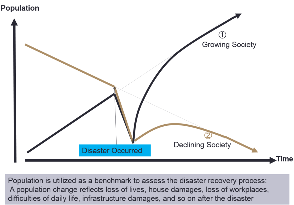
Disasters contribute to change, they do so primarily by accelerating trends that are already underway prior to impact (Bates et al., 1963; Bates, 1982; Bates and Peacock, 1993; Haas et al., 1977).

2) Theoretical framework 2
The disaster Process is influenced by
① Devoted aid volume from outside society
② Disaster scale
Community Strength (Social System Strength) (Hirose, 1982)

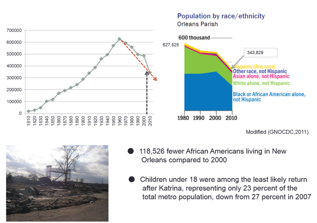
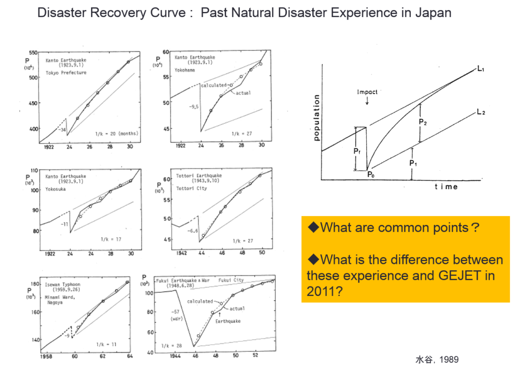
The first theory is confirmed by some cases. You can see the following figures: the Kanto earthquake, Fukui earthquake, Typhoon Isewan in Japan, and Hurricane Katrina in US.
mizutanisensei_recovery
Figure 2: Disaster Recoveries in Japan

recovery_katrina
Figure 3: The Disaster Recovery from Hurricane Katrina in US.

To be continued…

This is  the presentation summary. The presentation was made in 2011, after the tsunami in Japan.

Day_112 : The 1923 Great Kanto Earthquake and Disaster Prevention Day(Tentative)

September 1 is Disaster Prevention Day in Japan. This is because of the 1923 Great Kanto Earthquake. This quake caused over 105,000 casualties and had huge impacts on Japanese society. The Great Kanto Earthquake is the worst disaster in Japanese history. Here, some points are picked up. First, the quake directly attacks the capital city, Tokyo. Second, the disaster killed so many people mainly by fire, not objects falling. Third, rumors made the disaster worse. Fourth, Tokyo has recovered first and strongly.
With regard to the devastated areas, Tokyo and Kanagawa (Yokohama) populated areas were severely affected by the quake. The epicenter was located near Oshima Island in Sagami Bay, south of Tokyo. In Yokohama, 90 percent of all homes were damaged or destroyed. 60 percent of the city’s population became homeless (Brown University).
Concerning the fire, the time at which the earthquake hit was 11:58, so the families had prepared for their lunches. Many families’ cooking stoves were overturned by the quake, causing fires. The fire spread out with strong winds.
In respect of the rumors, the rumors, especially about Koreans, such as “Koreans do criminal activities and cause social confusion,” make the disaster more political. The Home Ministry declared martial law and ordered all sectional police chiefs to make maintenance of order and security top priorities. After the disaster, the radio became popular all over Japan. This is because of the disaster’s lessons.
Concerning the recovery, Shinpei Goto, Mayor of Tokyo, created and proceeded with a reconstruction plan for Tokyo to rebuild better. The basic infrastructure of today’s Tokyo was built during that time. 

*Death numbers were revised after the recent research from over 140,000 to 105,000 because there were several double countings.

Day_195 : Scientists and Disaster Management Controversy issues with a L’Aquila Earthquake Case

The L’Aquila earthquake, which struck the Abruzzo region of Italy on April 6, 2009, was a significant case study for both scientists and disaster risk management professionals for several reasons. With a magnitude of 6.3, this earthquake caused extensive damage to the medieval city of L’Aquila, resulting in the deaths of more than 300 people, injuring over a thousand, and leaving tens of thousands of people homeless. Beyond the immediate physical damage and tragic loss of life, the L’Aquila earthquake raised important issues related to earthquake prediction, risk communication, and the responsibilities of scientists and authorities in disaster risk management.

Scientific Aspects and Controversies

The occurrence of earthquakes sparked a controversial debate over the ability to predict earthquakes and the communication of seismic risks to the public. Before the earthquake, a series of tremors were felt in the region, leading to heightened public concern. A week before the major earthquake, a meeting of the Major Risks Committee, which included government officials and scientists, was held to assess the situation. The committee concluded that it was not possible to predict whether a stronger earthquake would occur but reassured the public, suggesting a low likelihood of a major event. Unfortunately, the devastating earthquake struck shortly thereafter.

This situation has led to significant controversy, particularly regarding the role and communication strategies of scientists and government officials in disaster risk management. Critics argued that reassurances were misleading and contributed to a false sense of security among the population.

Legal and Ethical Issues

In a highly controversial decision, six Italian scientists and one government official were initially found guilty of manslaughter in 2012 for underestimating the risks and failing to adequately warn the population. This verdict was widely criticized by the international scientific community, which argued that it was unreasonable to expect scientists to accurately predict earthquakes. The verdict was largely overturned in 2014, with the convictions of scientists being annulled and the sentence of the government official being reduced.

Disaster Risk Management Implications

The L’Aquila earthquake underscored the importance of effective disaster-risk management and communication strategies. Key lessons include:

  1. Communication of Uncertainty: It highlighted the need for clear communication of scientific uncertainty to the public. Conveying the inherent uncertainties in earthquake prediction is crucial for helping individuals and communities make informed decisions about risk reduction and preparedness.
  2. Public Education and Preparedness: The tragedy reinforced the need for ongoing public education on disaster preparedness and the importance of building earthquake-resilient communities.
  3. Building Codes and Urban Planning: Ensuring strict adherence to earthquake-resistant building codes and urban planning practices is vital in reducing the vulnerability of buildings and infrastructure.
  4. Multi-disciplinary Approach: The event demonstrated the importance of a multi-disciplinary approach that includes not only seismologists but also engineers, urban planners, emergency management professionals, and policymakers in disaster risk management planning and response.
  5. Ethical Responsibilities: The aftermath raised questions about the ethical responsibilities of scientists and the balance between preventing public panic and ensuring preparedness.

The L’Aquila earthquake remains a case study of the complex interplay among science, policy, ethics, and public communication in the context of natural disaster risk management.

Day_107 : Italy-Recent earthquake and past earthquake disasters

Below is the outline of the earthquake disaster in Italy from ADRC.
“A magnitude 6.2 quake hit at 03:36 (01:36 GMT) on April 24, 2016, 100km (65 miles) north-east of Rome, in central Italy. More than 70 people were killed in the earthquake.”

However, Reuters mentioned, “The death toll from a devastating earthquake in central Italy climbed to 250 on Thursday as rescue teams scoured mounds of rubble for a second day in towns and villages flattened by the natural disaster.” on Friday, two days after the quake.

In addition, the source also added, “Almost 200 of the victims died in Amatrice, which is famed for a local pasta dish and was full of holiday makers ahead of its 50th annual food festival, set for this weekend.”

Historically speaking, Italy has had a lot of earthquake disasters that have caused huge numbers casualties. Italy has had 44 earthquakes that have caused over 1,000 deaths since 1600. The interval is approximately . 25 years. They happened mostly in the central and southern part of Italy around the Apennine mountains and caused huge casualties. One of the reasons they had a large number of casualties was the stone-built houses.

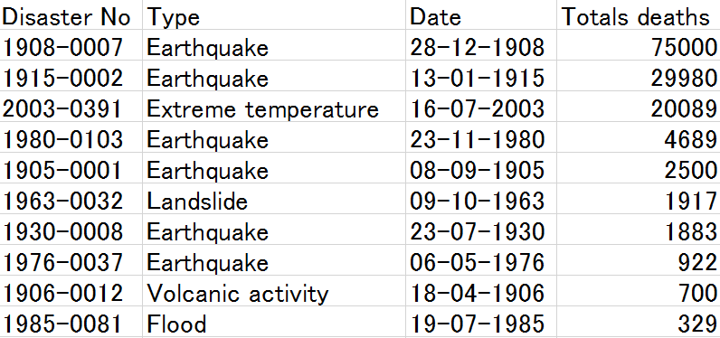
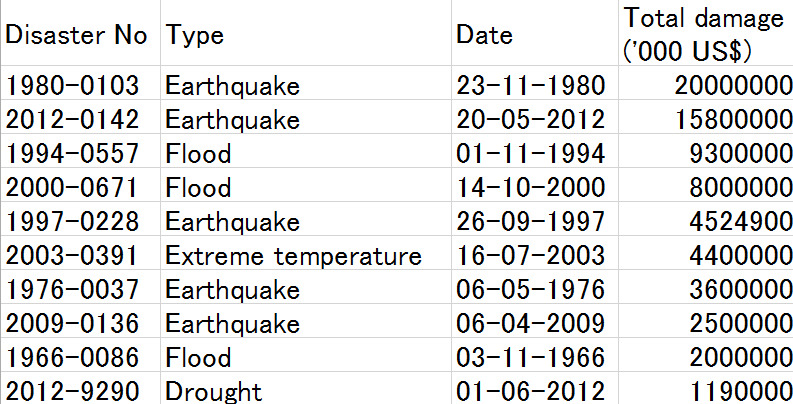
Table 1 and Table 2 show the 1900–2016 top 10 deadliest and costliest disasters in Italy (EM-DAT).

Table 1: Total deaths
Italy deadliest

Table 2: Total damage
Italy costliest disasters

Southern Italy had an earthquake (M6.9) in Campania (1980 Irpinia earthquake), the dead number is approximately . 4700, damage is 20 billion USD. The 2009 L’Aquila earthquake (M6.3) occurred and caused approximately death and 2.5 billion USD damage. This earthquake became controversial because the scientists and government officers were sentenced to six years in prison for their false announcement. The quality of construction also became an issues “Once again, we are faced with a lack of control over the quality of construction.” “In California, an earthquake like this one would not have killed a single person,” Franco Barberi, who heads a committee assessing earthquake risks at Italy’s Civil Protection agency, told reporters in L’Aquila (Reuters AlertNet) after the quake.

1908 Messina earthquake (M7.1) had caused the highest death number (75,000) in Italian history since 1900.

Reuters said still now (26, 2016), “Italy has a poor record of rebuilding after quakes. About 8,300 people who were forced to leave their houses after a deadly earthquake in L’Aquila in 2009 are still living in temporary accommodation.”


Day_186: Timeline for Hurricane Sandy

Moving forward, it is crucial that we continue to prioritize disaster management and invesin mitigation measures to minimize the impact of future disasters. This includes implementing resilient infrastructureconducting regular risk assessments, and engaging with communities to ensure their activparticipation in preparednesand recovery efforts. Additionally, we must continue to improve our communication strategies, utilizing various channels to disseminate timely and accurate information to the public. By learning from the lessons of Hurricane Sandy, we can strengthen our disaster management plans and better protect our communities in the face ofuture challenges.

Hurricane Sandy, which struck the East Coast of the United States in October 2012, is often cited as a case where disaster management and the use of a disaster management timeline played a crucial role in mitigating impacts and facilitating recovery. The response to Hurricane Sandy involved extensive pre-event planning and post-event recovery efforts that spanned the four phases of disaster management: mitigation, preparedness, response, and recovery.

1. Mitigation
Prior to Hurricane Sandy, New York had already invested in some mitigation measures based on lessons learned from previous storms, though the scale of Sandy’s impact highlighted the need for more extensive measures.

How New York Used Mitigation:
The city had begun to implement its PlaNYC initiative, aimed at preparing the city’s infrastructure for the impacts of climate change, including rising sea levels and more frequent severe weather events.

2. Preparedness
As Hurricane Sandy approached, New York’s state and city officials took several steps to prepare for the impending storm.

How New York Used Preparedness:
Evacuation Orders: Mandatory evacuation orders were issued for residents in low-lying areas, known as Zone A, affecting approximately 375,000 people.
Public Information: Information was disseminated through multiple channels, including social media, to keep the public informed about the storm’s progress and safety measures.
Transit Shutdown: The Metropolitan Transportation Authority (MTA) shut down subway, bus, and commuter rail services in anticipation of the storm to protect the system and its users.

3. Response
Once Hurricane Sandy made landfall, the response phase was immediate, with efforts focused on life-saving measures and ensuring the safety of the affected population.

How New York Used Response:
Emergency Services: First responders and emergency services worked tirelessly to rescue those stranded by the floodwaters and to provide immediate aid.
Power Restoration: Efforts were quickly organized to restore power to the millions of residents left in the dark.
Supply Distribution: Critical supplies, including food and water, were distributed to residents, especially in the hardest-hit areas.

4. Recovery
The recovery from Hurricane Sandy has been long-term, with efforts ongoing in some areas years after the storm.

How New York Used Recovery:
Rebuilding Infrastructure: Significant investments were made to rebuild and strengthen the city’s infrastructure, including electrical grids, transportation systems, and coastal defenses.
Resilience Planning: The storm’s impacts led to a heightened focus on resilience and the development of more robust plans to protect against future disasters, such as the “Rebuild by Design” competition that sought innovative solutions for coastal protection.
Community Support and Rebuilding: Efforts were made to support affected communities through the rebuilding process, including financial assistance for homeowners and businesses.

Lessons Learned and Implementation
The response to Hurricane Sandy highlighted the importance of preparedness and the need for robust mitigation and recovery planning. New York’s experience with Sandy has informed subsequent disaster management efforts, emphasizing the need for resilient infrastructure, comprehensive planning, and community involvement in disaster preparedness and recovery strategies.

The use of a disaster management timeline in the context of Hurricane Sandy demonstrated how proactive and reactive measures can mitigate the impact of such events and aid in the recovery process. It also showed the importance of continuous improvement in disaster management plans, incorporating lessons learned to enhance future preparedness and response efforts.

References:

Rosen, Y., & Yakubov, N. (2013). Hurricane Sandy: Lessons Learned from the Severely Damaged Coney Island Hospital, Prehospital and Disaster Medicine, 28(6), 643. https://doi.org/10.1017/S1049023X13008807

Barthel, E. R., Pierce, J. R., Speer, A. L., Levin, D. E., Goodhue, C. J., Ford, H. R., Grikscheit, T. C., & Upperman, J. S. (2013). Delayed family reunification of pediatric disaster survivors increases mortality and inpatient hospital costs: A simulation study. *Journal of Surgical Research*, 184(1), 430. https://doi.org/10.1016/j.jss.2013.05.040

Deitchman, S. (2013). Enhancing Crisis Leadership in Public Health Emergencies. Disaster Medicine and Public Health Preparedness, 7(5), 534. https://doi.org/10.1017/dmp.2013.88

Schmeltz, M. T., González, S. K., Fuentes, L., Kwan, A., Ortega-Williams, A., & Cowan, L. P. (2013). Lessons from Hurricane Sandy: A Community Response in Brooklyn, New York. *Journal of Urban Health*, 90(5), 799. https://doi.org/10.1007/s11524-013-9818-9

Freund, A., Zuckerman, N., Luo, H., Hsu, H.-H., & Lucchini, R. (2014). Diesel and Silica Monitoring at Two Sites Following Hurricane Sandy. *Journal of Occupational and Environmental Hygiene*, 11(9), D131. https://doi.org/10.1080/15459624.2014.916809

Solecki, W., & Rosenzweig, C. (2014). Climate Change, Extreme Events, and Hurricane Sandy: From Non-Stationary Climate to Non-Stationary Policy. *Journal of Extreme Events*, 01(01), 1450008. https://doi.org/10.1142/S2345737614500084

Johnson, D. A. (2023). Exploring the Effectiveness of 311 Data in Disaster Recovery and Response: A Case Study of Hurricane Sandy in New York City. *Academic Commons*. Columbia University. https://academiccommons.columbia.edu/doi/10.7916/p6h0-vp31

Petkova, E. P., Beedasy, J., Oh, E. J., Sury, J., Sehnert, E. M., Tsai, W.-Y., & Reilly, M. J. (2017). Long-term Recovery From Hurricane Sandy: Evidence From a Survey in New York City. (Disaster Medicine and Public Health Preparedness). https://doi.org/10.1017/dmp.2017.57

Federal Emergency Management Agency. (n.d.). Remembering Sandy Five Years Later. Retrieved from https://www.fema.gov

These references cover a range of topics related to the impact of Hurricane Sandy, including healthcare challenges, family reunification, crisis leadership, community responses, monitoring of environmental hazards, policy changes due to climate change, the effectiveness of using public data for disaster recovery, and long-term recovery challenges faced by residents.

Day_180: The Aftermath of “Natural” Disasters: Long-term Effects

The enduring consequences of natural disasters can be equally as catastrophic as their immediate repercussions. They frequently result in economic instability, social turmoil, and environmental destruction. Furthermore, they have the potential to establish a harmful cycle of destitution and susceptibility, particularly in developing countries.

For example, the act of demolishing infrastructure has the potential to interrupt vital services, including healthcare, education, and transportation. These consequences can have extensive effects on the progress of social and economic development, impeding endeavors to alleviate poverty and enhance living conditions.

<The Impact of Natural Disasters on Global Economies>

Natural disasters exert a substantial influence on global economics. They have the potential to inflict substantial financial losses, interrupt the flow of goods and services, and impede economic progress. Furthermore, they have the potential to worsen economic disparities, as individuals with few means are frequently the most severely affected.

As an illustration, the earthquake and tsunami that occurred in Japan in 2011 resulted in around $360 billion in losses, establishing it as the most expensive natural catastrophe in recorded history. The occurrence additionally prompted a nuclear catastrophe, exacerbating the economic and societal repercussions.

Day_177: Earthquake Preparedness and Response: Lessons from Turkey’s Seismic History

Image Source: FreeImages

The recent severe earthquake in Turkey has caused significant suffering throughout the country. This catastrophe serves as a stark reminder that natural disasters are far from ordinary occurrences. It is essential for us to learn and grow from each experience, not only within the affected country but also on a global scale. The article discusses Turkey’s earthquake history and how the nation has implemented lessons learned from past events. This analysis highlights the importance of continuous learning in order to better prepare for and respond to such disasters.

Introduction to Turkey’s seismic history

Turkey, a country bordering Europe and Asia, has suffered earthquakes before. It is incredibly vulnerable to these disasters because of its location on the seismically active Anatolian Plate. Turkey has historically seen some of the most damaging earthquakes in the world. Understanding the nation’s seismic history and drawing from its experiences can teach other countries valuable lessons on preparing for and responding to earthquakes.

A better understanding of how to predict, prepare for, and respond to these catastrophes has been made possible by the terrible impacts of earthquakes on Turkey. The country’s response plans have improved, using new engineering innovations and construction techniques to reduce casualties and property damage. In this post, we will examine Turkey’s seismic past, the significance of Adobe architecture there, and the lessons we can draw from Turkey to improve our readiness for and response to earthquakes.

Understanding earthquakes: Causes and types

Energy is released during the shifting and grinding of tectonic plates, which results in earthquakes. Large plates that make up the Earth’s crust are constantly moving and can collide, divide, or slide past one another, which can cause the ground to shake. Tectonic, volcanic, and induced earthquakes are the three main categories of earthquakes. The movement of the Earth’s plates causes the most frequent earthquakes, known as tectonic earthquakes. While induced earthquakes are brought on by human activity, like the mining of natural resources or the construction of huge reservoirs, volcanic earthquakes are brought on by the flow of magma beneath the Earth’s surface.

The Anatolian Plate, which is being compressed between the Eurasian and Arabian Plates, is Turkey’s leading cause of seismic activity. This tectonic activity has created numerous fault lines nationwide, making it vulnerable to earthquakes. For instance, the North Anatolian Fault, a strike-slip fault with a length of more than 1,000 kilometers, has caused multiple disastrous earthquakes in Turkey’s history.

The Significance of Adobe Structures in Turkey

Turkish architecture has long used adobe constructions built of soil mixed with straw or other organic materials. These constructions, frequently seen in rural locations, have served as fortifications, houses, and public facilities. The key benefits of Adobe structures are their affordability, simplicity, and great thermal qualities, which assist in maintaining a comfortable interior temperature all year round.

However, regarding seismic activity, Adobe constructions also suffer from serious drawbacks. These structures are particularly prone to collapsing during earthquakes because of their weight and low tensile strength. Throughout Turkey’s history, many large earthquakes have painfully illustrated this susceptibility, resulting in the death of countless people and extensive destruction.

Due to this, Turkey’s rising focus is on enhancing the seismic performance of Adobe structures. Researchers and engineers have been working on developing innovative techniques and materials to increase the earthquake resistance of these traditional structures and preserve their cultural relevance while ensuring the safety of their occupants’ safety.

Major earthquakes in Turkey’s history and their impact

Throughout its history, Turkey has been the site of many large earthquakes, some of which have had devastating effects. The Erzincan earthquake in 1939, the Izmit earthquake in 1999, and the Van earthquake in 2011 are three of the most famous. These seismic occurrences resulted in extensive property damage and fatalities and changed the nation’s strategy for earthquake preparedness and response.

Approximately 33,000 people perished in the 7.9-magnitude earthquake that struck Erzincan in 1939, and many more were injured or left homeless. This catastrophe made it clear that better seismic monitoring, prediction, and earthquake-resistant building techniques are required.

With nearly 17,000 fatalities and more than 50,000 injuries, the 1999 Izmit earthquake, which registered a 7.6 on the Richter scale, was among the deadliest and most catastrophic in modern Turkish history. The significant destruction brought on by this incident highlights the significance of strengthening earthquake preparedness and response strategies.

The most recent earthquake, the 7.1 magnitude Van earthquake in 2011, significantly damaged the Adobe structures in the area, killing over 600 people and displacing thousands more. This catastrophe also emphasized the necessity for improvements in construction methods and supplies for Adobe to improve its seismic performance.

Earthquake preparedness: What we can learn from Turkey

Turkey’s earthquake experiences have taught the country important lessons about preparedness. Adopting strict building regulations that account for seismic risks is crucial to earthquake preparedness. Turkey has made tremendous progress in this area; as of present, the country’s building codes demand that buildings be built resistant to earthquakes.

The creation and upkeep of early warning systems is vital to earthquake preparedness. Turkey has made significant investments in seismic monitoring and early warning systems, which can give locals crucial information in the minutes before an earthquake. By giving people enough time to take refuge or flee dangerous structures, this early warning can help save lives and reduce damage.

Finally, vital elements of earthquake preparedness are public awareness and education. Turkey has put a lot of effort into informing its inhabitants about the dangers of earthquakes and the essential safety measures to follow in the case of one. These are examples of regular earthquake exercises in schools, public awareness campaigns, and the distribution of earthquake safety informational materials.

Building earthquake-resistant Adobe structures

Several important regions have been the focus of efforts to increase the seismic performance of Adobe structures in Turkey. To strengthen their tensile strength and earthquake resistance, old Adobe buildings have been reinforced with contemporary materials like steel or concrete. Concrete columns, reinforced Adobe bricks, or the installation of steel reinforcement bars can all be used to achieve this.

Another strategy is the creation of fresh construction methods that more evenly disperse seismic pressures across the building. Using adaptable hardwood frameworks, using seismic-resistant design concepts, or using cutting-edge materials like fiber-reinforced Adobe are a few examples of how to do this.

Turkish scientists and engineers are also looking into the possibility of enhancing the earthquake resistance of Adobe constructions by employing locally derived ecological materials. This includes using natural fibers to increase the tensile strength of Adobe bricks, such as hemp or straw.

Effective earthquake response strategies in Turkey

The tactics used in Turkey to respond to earthquakes have also been informed. The quick deployment of rescue teams to find and aid stranded or injured people is crucial to an effective earthquake response. Specialized search and rescue squads in Turkey have received funding for training and equipment, and they are frequently among the first to arrive in earthquake-affected areas.

The provision of temporary housing and other services to displaced populations is a vital component of the earthquake response. Turkey has established an effective system for disaster response, including pre-stocked emergency supplies and temporary housing that can be quickly distributed to impacted communities after an earthquake.

Finally, effective earthquake response requires coordinated efforts from national and local governments, non-governmental organizations, and international partners. In the wake of significant earthquakes, Turkey has shown the usefulness of such cooperation, with international aid frequently playing an essential part in the nation’s rebuilding efforts.

Public awareness and education on earthquake preparedness

As informed populations are more prepared to respond to devastating disasters, public awareness, and education are essential to earthquake preparedness. The dissemination of educational materials, public awareness campaigns, and integration of earthquake safety education into school curricula are just a few of Turkey’s steps to increase general understanding regarding earthquake preparedness and response.

The “Safe School Program” is one significant part of Turkey’s public awareness campaigns. Schools are assessed for their capacity to withstand earthquakes as part of this program, and any necessary adjustments are made to protect the safety of students and staff in the event of an earthquake. Regular earthquake exercises are another curriculum feature that aids in preparing children and teachers for seismic occurrences.

International Collaboration for earthquake preparedness and Response

Because earthquakes are worldwide in scope, successful earthquake preparedness and response depend on international cooperation. The establishment of uniform building norms, the exchange of seismic monitoring data, and the provision of aid for disaster response are just a few of the ways that Turkey has actively participated in worldwide initiatives to increase earthquake resilience.

The World Housing Encyclopedia, which attempts to offer details on the seismic performance of structures worldwide, is a key endeavor in this area. Turkey has contributed to this effort by offering important information on the seismic performance of its conventional Adobe structures.

Building a resilient future for Turkey and Beyond

Turkey’s earthquake experiences taught us essential lessons about preparedness and response. Turkey has made tremendous progress in lessening the effects of earthquakes on its population by enacting strict construction rules, creating early warning systems, and improving public awareness about earthquake safety.

Researchers and engineers are looking for new methods and materials to increase the seismic performance of conventional Adobe structures in Turkey, which is a continuous effort. These initiatives could significantly impact earthquake-prone areas worldwide where traditional building materials and techniques are still widely used.

Finally, increasing earthquake resilience globally requires global cooperation and knowledge sharing. By cooperating, nations can benefit from one another’s experiences and create plans to lessen the effects of earthquakes on their populations.

To sum up, Turkey’s seismic past warns about the significance of earthquake preparedness and reaction. We can create a more resilient future for ourselves and future generations by implementing the lessons discovered from Turkey’s experiences in our communities.

Day_176: Empowering Pacific Island Countries: Innovative Strategies for a Disaster-Resilient Future


Let’s learn about disaster risk reduction in Pacific Island countries.

For Pacific Island countries (PICs), which are vulnerable to climate change and natural disasters, including tropical cyclones, earthquakes, tsunamis, and volcanic eruptions, disaster risk reduction (DRR) is a crucial part of sustainable development. These occurrences could severely impact the environment, the local economy, and the local communities. It is now more crucial than ever for PICs to concentrate on improving their capacity for disaster risk reduction and resilience.

The concept and practice of disaster risk reduction (DRR) are described by the United Nations Office for Disaster Risk Reduction (UNDRR) as “the concept and practice of reducing disaster risks through systematic efforts to analyze and manage the causal factors of disasters, including through reduced exposure to hazards, lessened vulnerability of people and property, wise management of land and the environment, and improved preparedness for adverse events.” This entails comprehending the particular difficulties that PICs confront in the Pacific region, figuring out the best ways to deal with these difficulties, and cooperating to secure a more resilient future for everyone.

This article discusses how crucial disaster risk reduction is for the Pacific region, looks at essential tactics for improving DRR, looks at examples of effective programs, and thinks about how local knowledge and global cooperation may help create a resilient culture. Pacific Island countries may lessen their susceptibility, promote sustainable development, and be better prepared for future calamities by implementing these measures.

Pacific Island countries face distinct challenges that are unique to their region.

Pacific Island countries have many specific difficulties when it comes to reducing the risk of disasters. First and foremost, they are particularly vulnerable to disasters because of their location. PICs are vulnerable to volcanic eruptions, earthquakes, and tsunamis because of their location along the Pacific Ring of Fire. The area is also frequently affected by tropical cyclones, which can result in extensive harm and destruction.

PICs’ low resources, disaster preparedness, and response capacity present another critical obstacle. Many of these nations’ inhabitants, infrastructure, and financial resources are modest. As a result, they frequently struggle to create and keep up with the required structures and methods for efficient disaster risk reduction.

Additionally, the effects of climate change are increasing already-existing threats and developing new ones for Pacific Island nations. Natural disasters are becoming more frequent and severe in the area due to rising sea levels, rising temperatures, and altering weather patterns. This makes improving disaster risk reduction in the Pacific much more complex and urgent.

Reducing the risk of disasters in the Pacific region is paramount.

It is impossible to exaggerate the significance of disaster risk reduction in the region of the Pacific. Natural disasters can wreak havoc and create great destruction, affecting the environment, the economy, and communities that persist for years. The Pacific island countries can lessen these effects, save lives, and safeguard their development achievements by investing in disaster risk reduction.

The Pacific region’s Sustainable Development Goals (SDGs) are also strongly related to disaster risk reduction. Natural disasters can directly influence many SDGs, including eradicating poverty, ensuring health and well-being, and fostering sustainable cities and communities. Pacific Island countries may advance toward these objectives and guarantee a more sustainable future for all by improving their capacity for disaster risk reduction.

Finally, reducing the risk of disasters is essential to helping Pacific Island communities become resilient. Communities’ capacity to resist shocks and pressures like disasters, recover from them, and adapt to them is called resilience. By implementing efficient disaster risk reduction initiatives, PICs may empower their communities to increase their resilience and preparedness for future catastrophes.

Discover some highly effective techniques to enhance disaster risk reduction with the following suggestions:.

Climate change adaptation

The effects of climate change are one of the biggest obstacles to disaster risk reduction that Pacific Island countries must overcome. As a result, any DRR strategy in the area must include adaptation to climate change as a critical element. Some examples of adaptation methods are enhancing coastal defenses, implementing sustainable land- and water-management practices, and creating climate-resilient agriculture and fisheries.

Climate factors must be incorporated into development planning and decision-making processes as part of climate change adaptation. This can help ensure that investments and development initiatives are created to resist climate change’s effects and not unintentionally raise the risk of disaster.

Infrastructure resilience

Improving infrastructure resilience is crucial for boosting disaster risk reduction in the Pacific. This entails ensuring that critical infrastructure, such as transportation networks, energy production facilities, and water and sanitation systems, is planned, constructed, and maintained to withstand the effects of natural disasters and climate change.

Developing and enforcing construction rules and standards, using cutting-edge technologies and materials, and integrating risk assessments and management strategies into the planning and design processes for infrastructure are all ways to increase its resilience. Pacific Island countries can lessen the potential harm brought on by disasters and assure the ongoing provision of critical services both during and after disasters by investing in resilient infrastructure.

Early warning systems

Implementing efficient early warning systems is paramount in enhancing disaster risk reduction efforts in the Pacific region. The aforementioned systems can provide precise and prompt data regarding imminent perils, enabling communities and governing bodies to undertake suitable measures to mitigate the consequences of disasters.

Early warning systems encompass a variety of technologies and methodologies, including but not limited to satellite-based monitoring, seismometers, and community-based observation networks. Apart from the development and execution of stated systems, it is crucial to guarantee that communities possess the ability and knowledge to understand and respond to early warning information.

Community engagement and Preparedness

Any practical disaster risk reduction approach must include community involvement and preparedness. Pacific Island countries may ensure that local needs and views are considered and that communities have a greater capacity to respond to and recover from disasters by involving communities in designing, implementing, and monitoring DRR programs.

Creating community early warning systems and carrying out of regular disaster exercises are examples of community-based disaster preparedness initiatives. Additionally, community participation can increase the efficacy and support for DRR activities by fostering trust between citizens and authorities.

Case studies of successful disaster risk reduction initiatives

The successful implementation of various disaster risk reduction efforts in Pacific Island countries has shed light on practical methods for strengthening DRR in the area. The Pacific Catastrophe Risk Assessment and finance project (PCRAFI), which emerged in response to the expanding demand for disaster risk finance in the Pacific, is one such project.

Participating countries have access to catastrophe risk models, financial safety nets, and technical assistance for disaster risk management through PCRAFI. With the tools and resources it offers, the project has proven to be a highly successful means of assisting Pacific Island countries to identify and manage their disaster risk.

The Pacific Climate Change and Migration (PCCM) project, which intends to raise the resilience of vulnerable populations in Fiji and Tuvalu to the effects of climate change, including displacement and migration, is another effective program. The project has concentrated on a variety of interventions, such as the building of climate-resilient infrastructure, the promotion of community-based disaster risk reduction, and the development of sustainable methods for livelihood.

The PCCM project highlights the value of tackling the underlying factors that increase disaster risk, such as climate change and incorporating disaster risk reduction (DRR) into larger development projects. Pacific Island countries may create more resilient and sustainable populations by approaching disaster risk reduction strategically.

The Role of international cooperation in disaster risk reduction

Effective disaster risk reduction in the Pacific region requires global cooperation. International cooperation and support are crucial because many Pacific Island countries lack the resources and capacity to manage their disaster risk independently.

International cooperation can take many forms, including knowledge sharing, capacity building, and financial and technical support. For instance, the United Nations Development Programme (UNDP) has generously supported initiatives in the Pacific to reduce disaster risk, such as creating early warning systems, establishing community-based disaster preparedness programs, and promoting climate change adaptation.

Incorporating regional expertise and customs into DRR activities can be significantly aided by international cooperation. International partners can contribute to ensuring that DRR strategies are practical and culturally appropriate by collaborating closely with local communities and traditional leaders.

Incorporating local knowledge and traditional practices

Initiatives for reducing the risk of disaster must incorporate local expertise and customs to be effective and long-lasting. The inhabitants of the Pacific Islands have abundant knowledge and experience in dealing with natural disasters, and their customs and traditions can offer essential insights into efficient DRR techniques.

Many Pacific Island societies, for instance, have created complex early warning systems using their understanding of the environment and natural occurrences. Countries in the Pacific Islands can improve their capacity for disaster preparedness and response by integrating these systems into more comprehensive DRR policies.

Culturing climate-resilient crops and constructing cyclone-resistant homes are examples of traditional practices that can offer important insights into effective adaptation strategies. Pacific Islander countries may create more resilient and sustainable communities by recognizing and adopting these practices into DRR projects.

Building a Culture of Resilience in Pacific Island Communities

Effective disaster risk reduction in Pacific Island communities depends on fostering a culture of resilience. This entails implementing efficient DRR measures and giving communities the tools they need to manage their risk of disasters and increase their resilience.

Communities can be empowered to actively participate in disaster preparedness and response through community-based approaches to disaster risk reduction, such as those used in the PCCM project. These techniques can also assist in fostering trust and collaboration between communities and authorities.

Furthermore, building a culture of resilience in Pacific Island communities can be facilitated by raising awareness and educating people about disaster risk reduction. Pacific Island countries may create more resilient communities and lessen the potential effect of natural disasters by giving populations the expertise and skills they need to understand and handle their disaster risk.

Monitoring and evaluating disaster risk reduction progress

Monitoring and assessing their progress is crucial for disaster risk reduction strategies to be effective and persistent. Pacific Island countries can continuously hone and enhance their DRR strategies, enhancing their capacity for resilience over time by monitoring progress and identifying areas for improvement.

The development of data management systems, setting up surveys and evaluations, and establishing performance indicators are just a few examples of the various ways that monitoring and evaluation can be carried out. Pacific Island governments may ensure that their DRR projects are based on evidence and successful by investing in these tools and procedures.

Envisioning a Robust and Sustainable Future for Pacific Island Nations through Collaborative Endeavors and Holistic Strategies

It takes a variety of tactics and approaches to effectively increase disaster risk reduction in Pacific Island countries. Pacific Island countries may build a more robust future for all people by emphasizing infrastructure resilience, early warning systems, community participation and preparedness, and incorporating indigenous knowledge and traditional practices.

Effective disaster risk reduction in the Pacific requires global cooperation and encouraging a resilient culture. Pacific Island nations can lessen their susceptibility to natural disasters and promote sustainable development by cooperating and strengthening local populations.

Monitoring and evaluation will be crucial to ensuring that DRR projects in the area are successful and long-lasting. By continuously enhancing and upgrading our methods, we can create a more resilient and prosperous future for Pacific Island nations and their populations.
Day_166: Interview Report: Hurricane Katrina Response (3)

>>>>>>>>>>>>>>>>>>>>>>>>>>>>
Date and time
7 May 2006

Visit
New Orleans Homeland Security and Public Safety Office
(New Orleans City Office of Homeland Security and Public Safety )

Interviewee
Colonel and Director

Subject
Hurricane Katrina Disaster Response
>>>>>>>>>>>>>>>>>>>>>>>>>>>>>>>

https://disasterresearchnotes.site/archives/3002

There are three drainage canals in New Orleans. There is also a pump station for each. Since New Orleans is below sea level, water is constantly pumped from these pump stations and drained into Lake Pontchartrain.

The breakwater was corrupted by the storm surge. The water was flowing into the canal from the lake, and at the same time, the pump station had the maximum pressure with the water. The pumps were broken and became not-functioned.

After the hurricane, there was only one evacuation route that crossed the bridge over Mississippi. However, the route had been blocked. These also affected support activities.

<Measures for breakwater>
At present, the Corps of Engineers will set a lock at the entrance of the canal and close them to prevent water from flowing into the canal since this year.

The challenge from this year is the evacuation of West Bank citizens. Because the levees are weak, hurricanes can easily break them.

The levee can be effective this year, but the problem is that in the next two years, the pump station will have insufficient capacity to pump water.

< Future measures of the city >
The following three goals are set as future measures. First, leave no one in the shelter. Second, the city will assist those who have no access to evacuation. Third, improve the safety of city facilities and property before and after the disaster.

Another important point this year is to let all citizens evacuate two days before Hurricane hit. The challenge is the reality that many people would not try to evacuate. As a background, the levee is to be broken, needs to have a terrible situation imagination.

There is a plan to install floodgates in a wide range of wetlands in eastern New Orleans to prevent storm surges.

Political challenge, New Orleans, including the peripheral has originally 100 million people, was an energy supply base, there is a tremendous national influence, the people here have to work.

As a countermeasure, the city has provided a wireless system. The system had been unavailable after the Hurricane.

A radio station in City Hall as a countermeasure against rumors which had become a social issue during Katrina was set up to keep media members staying and unifying the correct information.

Related information

The NIED team went to New Orleans and Missippi coastal areas to investigate.
Characteristics of the 2005 Hurricane Katrina Disasters

The community data center is the best to investigate to grasp the trend by using stats.

https://disasterresearchnotes.site/archives/2975

Day_156: Matsushiro Earthquake Center

I will update a column of the NIED e-mail magazine which I wrote a long time ago because the content is not faded with time. (I will do this step by step in Japanese and English.) I will also add comments to update the situation.

Published April 5, 2010
NIED-DIL e-mail magazine: Matsushiro Earthquake Center

■ Matsushiro Earthquake Center ■

There is an organization called Matsushiro Earthquake Center in Matsushiro, Nagano Prefecture, Japan. The Center was established in February 1967 at the Japan Meteorological Agency in Matsushiro Town, Nagano Prefecture (now Nagano City), based on the Matsushiro Seismological Observatory, which was established in 1947. The background of this establishment is that between August 3, 1965, and April 17, 1966, insensitive earthquakes with seismic intensities 5 and 4 were observed three times each and a total of 6,780 earthquakes were detected in the Matsushiro town area. This severe earthquake activity has become a major social problem.

It is famous that Mayor Nakamura at that time said that he wanted to learn and research more than things and money, and that was the starting point of the center. The center is also well known as the location where was planned to build the imperial general headquarters at the end of the second world war. Besides, It is known that the experience gained from the observation of the earthquake has dramatically influenced the progress of earthquake prediction and disaster countermeasures today.

The author is organizing the records of the discourse at the time with the cooperation of the Japan Meteorological Agency’s Earthquake Observatory (Matsushiro Seismological Observatory) as the Disaster Information Office. I am surprised at the fascinating records. The fact that Matsushiro city was working to build a disaster-resilient town in the wake of an earthquake throughout the city is well communicated. For example, there was not only research on the earthquake itself but also research on the health status of students, including psychological aspects from nearby schools caused by a swarm. This was due to the cooperation of Matsushiro health centers and hospitals. It does not stop there. Members were active in the front lines of various fields at the time, such as landslide surveys caused by earthquakes and the impact on water supply facilities during earthquakes, reports from various perspectives.

I am sorry that the format, etc. is still insufficient, but I am starting to release these records on the HP in hopes that you can see it in a provisional form. Please see if you have time.

URL: http://dil.bosai.go.jp/library/matsushiro/MRecord.html

Now you can not access it, but you can ask NIED DIL for information.

Published on April 5, 2010

Matsushiro Seismological Observatory
https://www.data.jma.go.jp/svd/eqev/data/matsushiro/en/index.html