Environment」カテゴリーアーカイブ

Day_191 : The Comprehensive Guide to Understanding Droughts

Recent years have seen a substantial impact of both climate change and human activities on droughts, which are complex and multifaceted natural phenomena. Droughts are marked by prolonged periods of precipitation that fall below average, resulting in significant scarcity of water that has far-reaching consequences for economies and ecosystems worldwide. This expanded guide delves deeper into the causes of droughts, their wide-ranging impacts, and the innovative solutions needed to mitigate their effects.

Causes of Droughts

Droughts arise from a blend of natural variability and human-induced factors. Key natural causes include shifts in atmospheric circulation patterns, which can disrupt traditional weather patterns, and the ongoing challenge of global warming, which intensifies evaporation rates, reducing soil moisture and water availability. Human activities, such as deforestation, directly alter land use and local climates, further diminishing rainfall and aggravating drought conditions. Additionally, the unsustainable use of water resources and pollution significantly strain water supplies. A comprehensive understanding of these factors is essential for crafting effective and sustainable drought mitigation strategies.

The Multidimensional Impacts of Droughts

The consequences of droughts extend far beyond the immediate lack of water, affecting environmental, economic, and social spheres. Environmentally, droughts can cause severe soil degradation, loss of plant and animal life, and an increased incidence of wildfires. Economically, they can devastate agricultural productivity, leading to food scarcity, skyrocketing prices, and a decrease in energy production, especially in regions reliant on hydroelectric power. Socially, the effects of droughts can be devastating, causing displacement, heightening conflicts over dwindling resources, and exacerbating health crises due to limited water supplies. The impacts are particularly pronounced in developing nations, where agriculture forms the backbone of the economy.

Historical Context of Droughts

Historically, droughts have posed significant challenges to civilizations, with events like the Dust Bowl of the 1930s in the United States serving as stark reminders of their potential severity. Recent droughts, such as the prolonged one in California, underscore the increasing frequency and intensity of these events in the face of climate change. Studying these historical droughts offers invaluable lessons for current and future drought preparedness and response strategies.

Measuring and Monitoring Droughts

Accurately measuring and monitoring droughts is crucial for early detection and response. The Palmer Drought Severity Index (PDSI) and other metrics like soil moisture and streamflow offer insights into drought severity and progression. Advancements in remote sensing and satellite imagery provide comprehensive data on drought impacts over large areas, facilitating timely and effective mitigation efforts.

Global Drought Conditions and Responses

Droughts today impact vast regions globally, with severe conditions persisting in areas such as the Sahel in Africa, Maharashtra in India, and across Australia. These conditions call for a unified global response, integrating both traditional strategies and innovative technologies to address the multifaceted challenges of droughts.

Forward-Looking Solutions for Drought Mitigation

Sustainable water management practices are foundational to drought mitigation. Techniques like rainwater harvesting, water recycling, and the adoption of efficient irrigation methods can dramatically improve water security. Embracing drought-resistant crops and soil conservation techniques further bolsters agricultural resilience. Innovatively, solutions such as desalination and cloud seeding present promising avenues for augmenting water supplies, while genetically modified crops offer potential for enhanced drought resistance.

A Unified Call to Action

The challenge of droughts is formidable but not insurmountable. With a deep understanding of their causes and impacts, combined with a commitment to sustainable management and innovative solutions, we can confront droughts effectively. It is a collective responsibility, from policymakers to individuals, to foster a resilient and sustainable approach to water management. Together, we can ensure a water-secure future for all, safeguarding our environment, economy, and societies against the enduring challenge of droughts.

Day_180: The Aftermath of “Natural” Disasters: Long-term Effects

The enduring consequences of natural disasters can be equally as catastrophic as their immediate repercussions. They frequently result in economic instability, social turmoil, and environmental destruction. Furthermore, they have the potential to establish a harmful cycle of destitution and susceptibility, particularly in developing countries.

For example, the act of demolishing infrastructure has the potential to interrupt vital services, including healthcare, education, and transportation. These consequences can have extensive effects on the progress of social and economic development, impeding endeavors to alleviate poverty and enhance living conditions.

<The Impact of Natural Disasters on Global Economies>

Natural disasters exert a substantial influence on global economics. They have the potential to inflict substantial financial losses, interrupt the flow of goods and services, and impede economic progress. Furthermore, they have the potential to worsen economic disparities, as individuals with few means are frequently the most severely affected.

As an illustration, the earthquake and tsunami that occurred in Japan in 2011 resulted in around $360 billion in losses, establishing it as the most expensive natural catastrophe in recorded history. The occurrence additionally prompted a nuclear catastrophe, exacerbating the economic and societal repercussions.

Day_176: Empowering Pacific Island Countries: Innovative Strategies for a Disaster-Resilient Future


Let’s learn about disaster risk reduction in Pacific Island countries.

For Pacific Island countries (PICs), which are vulnerable to climate change and natural disasters, including tropical cyclones, earthquakes, tsunamis, and volcanic eruptions, disaster risk reduction (DRR) is a crucial part of sustainable development. These occurrences could severely impact the environment, the local economy, and the local communities. It is now more crucial than ever for PICs to concentrate on improving their capacity for disaster risk reduction and resilience.

The concept and practice of disaster risk reduction (DRR) are described by the United Nations Office for Disaster Risk Reduction (UNDRR) as “the concept and practice of reducing disaster risks through systematic efforts to analyze and manage the causal factors of disasters, including through reduced exposure to hazards, lessened vulnerability of people and property, wise management of land and the environment, and improved preparedness for adverse events.” This entails comprehending the particular difficulties that PICs confront in the Pacific region, figuring out the best ways to deal with these difficulties, and cooperating to secure a more resilient future for everyone.

This article discusses how crucial disaster risk reduction is for the Pacific region, looks at essential tactics for improving DRR, looks at examples of effective programs, and thinks about how local knowledge and global cooperation may help create a resilient culture. Pacific Island countries may lessen their susceptibility, promote sustainable development, and be better prepared for future calamities by implementing these measures.

Pacific Island countries face distinct challenges that are unique to their region.

Pacific Island countries have many specific difficulties when it comes to reducing the risk of disasters. First and foremost, they are particularly vulnerable to disasters because of their location. PICs are vulnerable to volcanic eruptions, earthquakes, and tsunamis because of their location along the Pacific Ring of Fire. The area is also frequently affected by tropical cyclones, which can result in extensive harm and destruction.

PICs’ low resources, disaster preparedness, and response capacity present another critical obstacle. Many of these nations’ inhabitants, infrastructure, and financial resources are modest. As a result, they frequently struggle to create and keep up with the required structures and methods for efficient disaster risk reduction.

Additionally, the effects of climate change are increasing already-existing threats and developing new ones for Pacific Island nations. Natural disasters are becoming more frequent and severe in the area due to rising sea levels, rising temperatures, and altering weather patterns. This makes improving disaster risk reduction in the Pacific much more complex and urgent.

Reducing the risk of disasters in the Pacific region is paramount.

It is impossible to exaggerate the significance of disaster risk reduction in the region of the Pacific. Natural disasters can wreak havoc and create great destruction, affecting the environment, the economy, and communities that persist for years. The Pacific island countries can lessen these effects, save lives, and safeguard their development achievements by investing in disaster risk reduction.

The Pacific region’s Sustainable Development Goals (SDGs) are also strongly related to disaster risk reduction. Natural disasters can directly influence many SDGs, including eradicating poverty, ensuring health and well-being, and fostering sustainable cities and communities. Pacific Island countries may advance toward these objectives and guarantee a more sustainable future for all by improving their capacity for disaster risk reduction.

Finally, reducing the risk of disasters is essential to helping Pacific Island communities become resilient. Communities’ capacity to resist shocks and pressures like disasters, recover from them, and adapt to them is called resilience. By implementing efficient disaster risk reduction initiatives, PICs may empower their communities to increase their resilience and preparedness for future catastrophes.

Discover some highly effective techniques to enhance disaster risk reduction with the following suggestions:.

Climate change adaptation

The effects of climate change are one of the biggest obstacles to disaster risk reduction that Pacific Island countries must overcome. As a result, any DRR strategy in the area must include adaptation to climate change as a critical element. Some examples of adaptation methods are enhancing coastal defenses, implementing sustainable land- and water-management practices, and creating climate-resilient agriculture and fisheries.

Climate factors must be incorporated into development planning and decision-making processes as part of climate change adaptation. This can help ensure that investments and development initiatives are created to resist climate change’s effects and not unintentionally raise the risk of disaster.

Infrastructure resilience

Improving infrastructure resilience is crucial for boosting disaster risk reduction in the Pacific. This entails ensuring that critical infrastructure, such as transportation networks, energy production facilities, and water and sanitation systems, is planned, constructed, and maintained to withstand the effects of natural disasters and climate change.

Developing and enforcing construction rules and standards, using cutting-edge technologies and materials, and integrating risk assessments and management strategies into the planning and design processes for infrastructure are all ways to increase its resilience. Pacific Island countries can lessen the potential harm brought on by disasters and assure the ongoing provision of critical services both during and after disasters by investing in resilient infrastructure.

Early warning systems

Implementing efficient early warning systems is paramount in enhancing disaster risk reduction efforts in the Pacific region. The aforementioned systems can provide precise and prompt data regarding imminent perils, enabling communities and governing bodies to undertake suitable measures to mitigate the consequences of disasters.

Early warning systems encompass a variety of technologies and methodologies, including but not limited to satellite-based monitoring, seismometers, and community-based observation networks. Apart from the development and execution of stated systems, it is crucial to guarantee that communities possess the ability and knowledge to understand and respond to early warning information.

Community engagement and Preparedness

Any practical disaster risk reduction approach must include community involvement and preparedness. Pacific Island countries may ensure that local needs and views are considered and that communities have a greater capacity to respond to and recover from disasters by involving communities in designing, implementing, and monitoring DRR programs.

Creating community early warning systems and carrying out of regular disaster exercises are examples of community-based disaster preparedness initiatives. Additionally, community participation can increase the efficacy and support for DRR activities by fostering trust between citizens and authorities.

Case studies of successful disaster risk reduction initiatives

The successful implementation of various disaster risk reduction efforts in Pacific Island countries has shed light on practical methods for strengthening DRR in the area. The Pacific Catastrophe Risk Assessment and finance project (PCRAFI), which emerged in response to the expanding demand for disaster risk finance in the Pacific, is one such project.

Participating countries have access to catastrophe risk models, financial safety nets, and technical assistance for disaster risk management through PCRAFI. With the tools and resources it offers, the project has proven to be a highly successful means of assisting Pacific Island countries to identify and manage their disaster risk.

The Pacific Climate Change and Migration (PCCM) project, which intends to raise the resilience of vulnerable populations in Fiji and Tuvalu to the effects of climate change, including displacement and migration, is another effective program. The project has concentrated on a variety of interventions, such as the building of climate-resilient infrastructure, the promotion of community-based disaster risk reduction, and the development of sustainable methods for livelihood.

The PCCM project highlights the value of tackling the underlying factors that increase disaster risk, such as climate change and incorporating disaster risk reduction (DRR) into larger development projects. Pacific Island countries may create more resilient and sustainable populations by approaching disaster risk reduction strategically.

The Role of international cooperation in disaster risk reduction

Effective disaster risk reduction in the Pacific region requires global cooperation. International cooperation and support are crucial because many Pacific Island countries lack the resources and capacity to manage their disaster risk independently.

International cooperation can take many forms, including knowledge sharing, capacity building, and financial and technical support. For instance, the United Nations Development Programme (UNDP) has generously supported initiatives in the Pacific to reduce disaster risk, such as creating early warning systems, establishing community-based disaster preparedness programs, and promoting climate change adaptation.

Incorporating regional expertise and customs into DRR activities can be significantly aided by international cooperation. International partners can contribute to ensuring that DRR strategies are practical and culturally appropriate by collaborating closely with local communities and traditional leaders.

Incorporating local knowledge and traditional practices

Initiatives for reducing the risk of disaster must incorporate local expertise and customs to be effective and long-lasting. The inhabitants of the Pacific Islands have abundant knowledge and experience in dealing with natural disasters, and their customs and traditions can offer essential insights into efficient DRR techniques.

Many Pacific Island societies, for instance, have created complex early warning systems using their understanding of the environment and natural occurrences. Countries in the Pacific Islands can improve their capacity for disaster preparedness and response by integrating these systems into more comprehensive DRR policies.

Culturing climate-resilient crops and constructing cyclone-resistant homes are examples of traditional practices that can offer important insights into effective adaptation strategies. Pacific Islander countries may create more resilient and sustainable communities by recognizing and adopting these practices into DRR projects.

Building a Culture of Resilience in Pacific Island Communities

Effective disaster risk reduction in Pacific Island communities depends on fostering a culture of resilience. This entails implementing efficient DRR measures and giving communities the tools they need to manage their risk of disasters and increase their resilience.

Communities can be empowered to actively participate in disaster preparedness and response through community-based approaches to disaster risk reduction, such as those used in the PCCM project. These techniques can also assist in fostering trust and collaboration between communities and authorities.

Furthermore, building a culture of resilience in Pacific Island communities can be facilitated by raising awareness and educating people about disaster risk reduction. Pacific Island countries may create more resilient communities and lessen the potential effect of natural disasters by giving populations the expertise and skills they need to understand and handle their disaster risk.

Monitoring and evaluating disaster risk reduction progress

Monitoring and assessing their progress is crucial for disaster risk reduction strategies to be effective and persistent. Pacific Island countries can continuously hone and enhance their DRR strategies, enhancing their capacity for resilience over time by monitoring progress and identifying areas for improvement.

The development of data management systems, setting up surveys and evaluations, and establishing performance indicators are just a few examples of the various ways that monitoring and evaluation can be carried out. Pacific Island governments may ensure that their DRR projects are based on evidence and successful by investing in these tools and procedures.

Envisioning a Robust and Sustainable Future for Pacific Island Nations through Collaborative Endeavors and Holistic Strategies

It takes a variety of tactics and approaches to effectively increase disaster risk reduction in Pacific Island countries. Pacific Island countries may build a more robust future for all people by emphasizing infrastructure resilience, early warning systems, community participation and preparedness, and incorporating indigenous knowledge and traditional practices.

Effective disaster risk reduction in the Pacific requires global cooperation and encouraging a resilient culture. Pacific Island nations can lessen their susceptibility to natural disasters and promote sustainable development by cooperating and strengthening local populations.

Monitoring and evaluation will be crucial to ensuring that DRR projects in the area are successful and long-lasting. By continuously enhancing and upgrading our methods, we can create a more resilient and prosperous future for Pacific Island nations and their populations.

Day_164 : Development Environment Disaster Cycle Model

As mentioned before in Day_56, it is clear the model, development-environment-disaster cycle model is an analyzer that can be considered in a wide range of areas. In other words, this analysis perspective raises the sociological position of natural disasters, and the stepping stone of their historical and geographical connections become clearer. We believe that it will even be possible to provide various perspectives to prevent it from being guided.

https://disasterresearchnotes.site/archives/2598

Analytical Viewing Angle by Causal Cycle Model: Case of Isewan Typhoon Disaster and Indian Ocean Tsunami Disaster

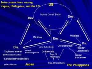
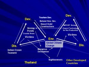
In this section, Isewan typhoon disaster and Indian Ocean tsunami disaster are specifically analyzed using the analysis view angle, the causal cycle model of development, environment, and disaster. The first is the Isewan Typhoon that hit Nagoya on September 26, 1959. The disaster was a turning point of disaster management in postwar Japan, but focusing on driftwood damage, which is one of the important aspects of the disaster, the economic recovery of postwar Japan, trade with the United States, and Japan. Forest management, natural disasters such as landslides, the problem of hay fever, which is also called national illness, and the inter-relationship between deforestation and natural disasters in the Philippines, which becomes today, will become clear. Second, regarding the Indian Ocean Tsunami that caused enormous damage on December 26, 2004, mainly in the countries around the Indian Ocean, the damage in Thailand will be analyzed. This analysis reveals the development-environment-disaster in Thailand and its relationship with Japan and Western countries.

The figures are shown as follows:

Figure 1: Interconnections of Typhoon Isewan Disaster

Figure 2: Interconnections of Indian Ocean Tsunami Disasters in Thailand

sponsored link

Day_150: Sea Level, Rainfall, and Temperature Changes in Thailand

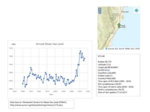
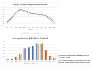
Bangkok is very hot this year.  Just share the results which I did on sea level, rainfall and temperature changes in Thailand from a long-range perspective.

The tide gauge at KO LAK in PrachuapKhri Khan indicates the annual mean sea level is rising. Especially, the sea level is rapidly rising after 2000.

Temperature

Warmer than before and the gap between warmer and colder (STD) is smaller.

Rainfall

Almost all the same average and std, but we can see the pattern (the peak) has changed.

The rainfall peak became earlier.

Will explain in detail later………..

Day_104 : Lessons from a Japanese Environmental Movement- The Matsumura Research Group (2)

Mishima Numazu Shimizu (MNS) environmental movement in 1963-1964 is the turning point of a Japanese environmental history. The core of the movement is the science-based issues, especially, The Environmental Impact Assessment conducted by the Government Research Group and the Local Research Group.

https://disasterresearchnotes.site/archives/2981

Proposed the Development Plan

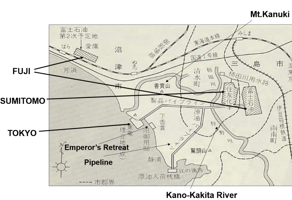
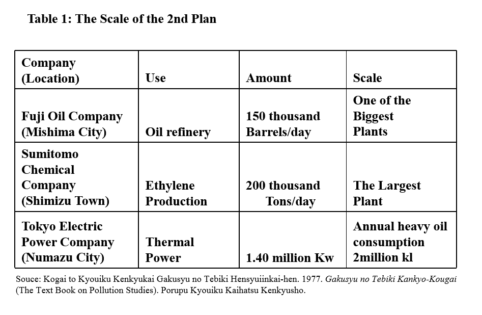
The below Figure 1 and Table 1 indicate the proposed development plan. These are the companies which had planned to come to the area. You can also see the scale of the plan.

planned project MNS
Figure 1  Proposed an Industrial Complex Plan

Table 1 The Scale of the Plan

The planned MNS

What is the MNS Movement?
The following two factors can be highlighted to explain the MNS movement. The first, the survey carried out by students (KOINOBORI research). The second, a few hundred education programs (mainly for local citizens)

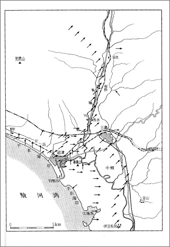
In regard to the student survey, the survey carried out by students of Numazu Technical High School consists of three types by using local materials which were KOINOBORI, empty bottles and thermometers. The KOINOBORI were used in the air current survey that was conducted by about 300 students. The students made some air current maps that showed that the government’s appraisal of wind direction was incorrect. These maps gave decisive data to the Matsumura research group. Empty bottles were used for the water current survey. Thermometers enabled the students to make some maps showing the variation of temperatures.

On the other hand, the results of the survey reported by students of East Numazu High School which were called “Petrochemical Complex Project in Numazu and Mishima Area” was conducted by a Local Research Club. They researched it by using social scientific methods (including the survey in Yokkaichi City). The MNS activists use this report.

With reference to the education programs, many education programs were conducted by Numazu Technical High School teachers. They were held at schools, at the town halls and in the streets. Because of the programs, local citizens (including farmers and fishermen) became eager to learn. Local citizens wanted to know what was going on in their locality.

The Students Participatory Survey

The following Figure 2  shows the wind directions are from the sea to the land. This map was created by the students during the Koinobori time. This means the local people would be influenced by the pollutions from the planned factories. However, the government survey appealed the different ways.

Wind directions student survey
Figure2  Wind directions survey conducted by high school students
(Source :  Mitsuo Taketani, 1967)

The Kurokawa Research Group (Gov. Research group) carried out the first largest ever Environmental Impact Assessment (EIA) by the Japanese government in 1964. The representative was Dr.Masatake Kurokawa and the staff consisted of national academics. The budget was about 20 million yen (about 180,000 USD) at that time. The research was carried out by using helicopters and high-tech machines. The Kurokawa Research Group was nominated by the Minister of International Trade and Industry and the Minister of Public Health.

On the other hand, the Matsumura Research Group carried out the EIA by getting the cooperation of local people, including high school students. The representative was Dr.Seiji Matsumura and the staff consisted of two researchers with international experience and local high school teachers (Table 2). The budget was about 100 thousand yen (about 900 USD) at that time. The research was conducted using readily available materials and low-tech manpower (for example, Koinobori research). It meant that research people, as well as the local people and high school students, used their own ideas. The Matsumura research group was nominated by the Mayor of Mishima city, Mr.Taizo Hasegawa. They use students, local materials, and Japanese culture.

Table 2 Matsumura Research Group

local research group members
* I have life stories about them by interview surveys

The Formation of the Matsumura Research Group

The following is the formation process of the Matsumura Research Group. The National Institute and the Local high school have bonded together. These make ‘Think globally, act locally’.

  1. Education Seminar about Pollution Held by Two High School Teachers and a Professor
  2. Explanation of the Estimated Pollution Levels Given to the NIG (National Institute of Genetics) by Mr.Nagaoka and Mr.Nishioka (Teachers)
  3. Decided by the NIG Members to Refuse the Petrochemical Complex Plan
  4. Advice Given to Mishima City’s Mayor (Hasegawa) from the NIG Members to Establish the Research Committee for EIA
  5. Decision by Hasegawa to Reject the Proposed Petrochemical Complex
  6. Acceptance of Numazu Technical High School and NIG to do EIA in the Area

To be continued.

Day_96 : Lessons from a Japanese Environmental Movement- The Matsumura Research Group (1)

Mishima Numazu Shimizu (MNS) environmental movement in 1963-1964 is the turning point of a Japanese environmental history. The core of the movement is the science-based issues, especially, Environmental Impact Assessmentsconducted by the Government Research Group and the Local Research Group.

They fought the results and local people finally assisted the local research group research findings and explanations to choose their future.

Actually, this is the first national EIA (Environmental Impact Assessment) in Japan, which failed and almost all Japanese do not know.

I conducted field research on the local research group for a long time. I stayed local member’s house for over 1 week and collected the documents, for example. Unfortunately, almost all members have passed away now. The followings are the outlines.

Background
In 1963, the national government and local councils proposed the one large industrial complex in Mishima city, Numazu town, and Shimizu town area in Shizuoka prefecture near to the Mt.Fuji.This was one of the largest development projects in Japan at that time. After this announcement, the MNS environmental movement was started with the local people. Local high school teachers and national research institute researchers led this movement with their scientific and local knowledge.

Revolutionary Events in the MNS Movement
– The survey carried out by high school students (KOINOBORI research)
because it happened  in a KOINOBORI time (Japanese culture)
→A high school teacher (The Matsumura Research Group member) led this survey.
→These results were accurate in the local wind direction which was against governmental research findings with explanations. Gov. research group had a huge budget, they used a helicopter to check the wind directions

koinobori
Figure 1 Koinobori   (Source: Wikipedia)

– A few hundred education programs (mainly for local citizens)

The Main Impact of the MNS movement
Former high-ranking officer confessed:
“We (the government) thought we had lost when the Numazu citizens flew those KOINOBORI (carp-shaped streamers) for research purpose. Besides that we also realized that we needed to make laws governing pollution. If we had not done it, we could not have been able to set up any MNS type projects”

The Main Impact of the MNS movement
Prevention Movement against Pollution
Local Government Reform Movement
Legal Action in the Movement
Conducting Independent Research
Implementing Environmental Education Programs

After the movement, Kawasaki City, Tokyo Metropolitan Area,
and Kyoto City became reformist local governments, which
control pollution more seriously than the national government.

Matsumura Research Group
Outcome: “Self Assessment” by the local research group overcome
the “Official Assessment” by the national research group

Mr. Shiramatsu (LDP) criticized during the time in the assembly:
“The Kurokawa Research Group (the national research group) is reliable.
It consists of the country’s most respected specialists in various fields.
They could be called the nation’s best brain. On the other hand, the
Matsumura Research Group (the local research group) is unreliable.
The member are 2 doctorates of Agriculture and 4 high school teachers.
How could they carry out reliable research?
In addition, I heard the budget
of the Matsumura Research Group is about 100 thousand yen. So the research
could be regarded a non-scientific thing”.

To be continued・・・・・

sponsored link

Day_59 : Lessons from a Japanese environmental movement

The UN emphasis the importance of building a bridge between science and policy*. The Mishima Numazu and Shimizu (MNS) environmental movement in 1963-1964 is really really turning point in Japan. After the movement, the Japanese environmental movement was spreading out all over Japan. Establishing the Japanese Environmental Impact Assessment (EIA) Law was delayed because of this movement. The core story related to science and policy is the conflict between the governmental EIA research group and the local EIA group. The government group used high-tech machines and money, but the local research group used high school students, local people, and local knowledge. For example, the government group did research by using a helicopter to check the wind direction, on the other hand, the local group used a carp-shaped streamer for examining the direction around the 5th of May in 1963. Japanese people usually raise carp-shaped streamers in front of the house to celebrate their children’s prosperity. Finally, local people, including farmers and fishermen studied hard to recognize the environmental impacts of their living areas and chose the local research group results.

*https://sustainabledevelopment.un.org/?page=view&nr=1101&type=230&menu=2059