Day_93: Natural disasters in Thailand – National Disaster Risk Assessement Mapping

Day_18 mentioned, “More must be done to fight climate change” (Bangkok Post)

https://disasterresearchnotes.site/archives/2304

The national risk assessment mapping in Thailand is briefly explained below.

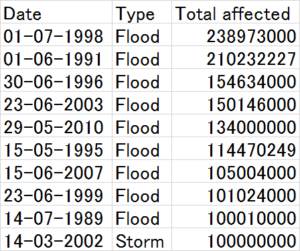
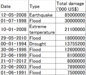
Table 1  Disaster data in Thailand
em-dat_thailand
The target period of these EM-DAT data is from 1900 to 2014. However, the large numbers of deaths, affected people, and damage costs caused by natural disasters are all after the 1970s, as shown in Table 1. The data clarify that the 2004 Indian Ocean Tsunami and the 2011 Chao Phraya River flood disasters have been very influential in Thailand.

riskmapping_thailand
Figure 1 National Risk Assessment Mapping in Thailand

Figure 1 was created using EM-DAT data from Thailand (1900-2014). This risk assessment mapping (Frequency-Impact by each damage type) is very simple, but it allows us to easily grasp the whole picture of the risks.

The following risk matrix options help evaluate each risk.
riskoption1
Figure 2 Risk matrix options (1)

riskoption2
Figure 3 Risk matrix options (2)

From Figure 1, it is clear that the flood is the disaster that requires the most countermeasures in Thailand. Figures 2 and 3, for example, show that extensive management and monitoring are essential, and immediate action must be taken against the floods.

The above explanations are very rough. Detailed descriptions will be discussed later.

The above was already published with explanations as a report for the Japanese Association for Earthquake and Engineering (JAEE).

Day_72 : 1983 Sea of Japan earthquake

The 1983 Sea of Japan earthquake, also known as the 1983 Nihonkai-Chubu earthquake, occurred on May 26. It was 7.8 magnitude and occurred in the Sea of Japan. The tsunami caused 104 deaths, 100 caused by the quake. The tsunami hit communities along the coast, primarily in Aomori and Akita Prefectures and the east coast of Noto Peninsula.
There are three things to share about the tsunami disaster.
The first is the tsunami-generated location, the second is the broadcasting, and the third is the victims of school children. First, there was an ancient tradition that tsunamis never hit the coast of the Sea of Japan. This normalcy bias* exacerbates the damage. The second was the first tsunami disaster broadcast worldwide during that time. The people who had home videos also contributed to the media. The tsunami warning system, which provides wireless tsunami information from the Sea of Japan to the local area to inform local people, was improved after the event. Third, 43 schoolchildren were hit, and 13 passed away. They were on an excursion. The school teacher could not do anything during that time. The 2011 Great East Japan Earthquake and Tsunami disaster also had teacher-related issues. Both tsunamis were daytime.

*Normalcy bias

http://disasters.weblike.jp/disasters/archives/2607

Day_65 : 1991 Unzen Fugendake Volcano Eruption

1991 Unzen Fugendake Volcano Eruption Killed 43 people. This disaster has taught a lot of lessons. The key words are media, volunteer firefighters, police officers, and an evacuation area. The people were all dead in the evacuation area. During the volcano eruption, media people tried to get into the area to shoot pictures, videos, and report. They went into the local people’s houses. The residents were worried about their belongings in their houses. So many volunteer firefighters (12) also went into the area to check, and police officer (2) also did that. The taxi drivers (4) bring them into the area. They all died in the area. Katia Krafft and Maurice Krafft, world’s famous French volcanologists were also dead during the disaster.


Wikipedia (Katia and Maurice Krafft)
https://en.wikipedia.org/wiki/Katia_and_Maurice_Krafft

Wikipedia (Unzen Fugendake Pyroclastic flow, Japanese)
https://ja.wikipedia.org/wiki/%E9%9B%B2%E4%BB%99%E5%B2%B3#1991.E5.B9.B46.E6.9C.883.E6.97.A5.E3.81.AE.E7.81.AB.E7.A0.95.E6.B5.81

Day_64 : 1985 Nevado del Ruiz Volcano Eruption

One of the most significant volcanic disasters we must know about is the 1985 Nevado del Ruiz volcano eruption. Approx.23000 citizens in Armero city were dead. The cultural aspects were embedded in this disaster. The disaster was predicted. The hazard maps indicate that the city will be affected by a volcanic eruption and lahars. Both priest and mayor told the citizens to stay in the same place because they were afraid of panic before the time, but did not tell them to evacuate. That made tragedy. The people in the city tended to follow both persons because of the culture, which is a religious and vertically structured society. There were also other factors*.


*https://en.wikipedia.org/wiki/Nevado_del_Ruiz#Eruption_and_lahars


Day_63: Snowstorm Disaster : Stories and Projects – The father held his daughter in his arms

There were nine casualties caused by heavy snowstorms in Hokkaido on 2-3 March 2013.
In Yubetsu town, a father (58) was found dead. But his daughter (9) survived. The father held his daughter in his arms to protect her from coldness.
In Nakashibetsu town, four were dead. They died in a car because they stopped the car and could not go out because of the conditions. They tried to call acquaintances for help again and again. However, they could not get help during that time.

The Snow and Ice Research Center, NIED (National Research Institute for Earth Science and Disaster Prevention), has launched a project to prevent snowstorm disasters after the disaster in Nakashibetsu. The project focused on the snowstorm prediction system not only for officers but also for local people. It is difficult to predict the storm because it happens with complex conditions, such as snow drift and storms. I needed to check not only the weather but also the land conditions.

An example of the use is that the school children stopped to go back home because the snow storm was predicted on their way home.


Day_209 : Snow Disasters: When Winter Wonderland Turns into a Nightmare

Winter’s beauty can turn dangerous with heavy snow, blizzards, and ice storms. These snow disasters cause power outages, transportation chaos, and property damage. But what causes them, and how can we prepare?

The Science of Snowstorms

Snow disasters happen when cold temperatures, precipitation, and wind combine. Think of heavy snowfall, icy roads, and massive snowdrifts. Climate change is making things worse with more intense snow and hazardous ice.

The Impact

Snow disasters disrupt transportation, causing accidents and delays. Power lines snap under the weight of snow, leading to blackouts. Buildings can even collapse, and ice dams cause leaks and damage.

Fighting Back: Snow Removal and Prevention

Traditional methods like shoveling and plowing are still essential. But we now have snowblowers, snowmelt systems, and de-icing techniques. Advanced weather prediction helps us prepare, and GPS-guided snowplows clear roads faster.

Be Prepared!

Even with the best technology, snowstorms can still hit hard. Have an emergency kit with food, water, blankets, and a first aid kit. Plan for transportation and communication in case of an emergency.

Stay safe and warm this winter!

# Image Source: Unsplash‍


Day_208 : Understanding Disease Complexity: A Modern Perspective

The disease is far more than a simple malfunction in the body—it’s a complex interplay of multiple factors that affect millions worldwide. Understanding this complexity is crucial for developing effective treatments and prevention strategies.

The Three Pillars of Disease Development

  1. Genetic Factors

Our genetic makeup significantly influences disease susceptibility. A notable example is the BRCA1 and BRCA2 genes (Breast Cancer genes), which normally help repair damaged DNA and suppress tumor growth. When these genes have mutations, they can significantly increase a person’s risk of developing breast and ovarian cancer, demonstrating how genetic variations can impact our health.

  1. Environmental Influences

External factors—from air pollution to workplace exposures—can trigger disease development. For instance, asbestos exposure’s link to mesothelioma demonstrates how environmental factors can interact with genetic predispositions.

  1. Lifestyle Choices

Diet, physical activity, and stress management play crucial roles in preventing and progressing diseases. These modifiable factors often represent our best opportunity for disease prevention.

COVID-19: A Case Study in Disease Complexity

The COVID-19 pandemic perfectly illustrates the intricate nature of the disease. This single virus has demonstrated how multiple factors affect disease outcomes:

  • Genetic Factors: Studies have shown that genetic variations can influence the severity of COVID-19, with some people more susceptible to serious illness.
  • Environmental Impact: Population density, indoor ventilation, and climate conditions all affect virus transmission rates.
  • Social Determinants: Access to healthcare, living conditions, and occupation type have significantly influenced infection rates and outcomes.
  • Individual Responses: The wide range of symptoms—from asymptomatic cases to severe illness—highlights how differently individuals can respond to the same pathogen.

This pandemic has also accelerated medical innovations, from mRNA vaccine development to telemedicine adoption, showing how crisis can drive healthcare advancement.

The Future of Disease Management

Modern medicine is moving away from one-size-fits-all approaches. Personalized medicine, which considers an individual’s unique genetic profile and environmental exposures, is becoming the new standard. Technologies like pharmacogenomics help doctors prescribe medications that will work best for each patient while minimizing side effects.

Looking Ahead

As we continue to understand disease complexity, new technologies, and research methods are opening doors to better treatments. From wearable devices to telemedicine, these advances are making healthcare more accessible and effective than ever before.

Understanding disease complexity isn’t just academic—it’s the key to developing better treatments and prevention strategies that can improve health outcomes for everyone.

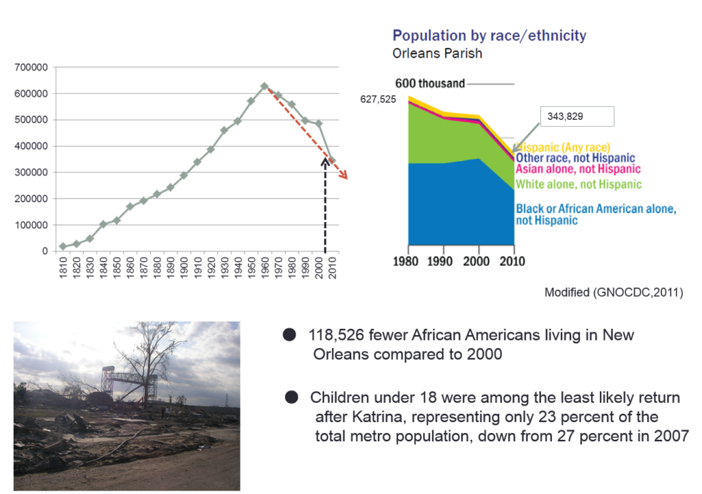
Day_207 : Lessons from Hurricane Katrina: A Retrospective Analysis and Future Implications for Disaster Risk Reduction


The picture was taken in Mississippi on December 3, 2005.

Nearly two decades have passed since Hurricane Katrina devastated the Gulf Coast, particularly New Orleans, in 2005. As we reflect on this catastrophic event, it’s crucial to reassess our understanding of the disaster, its impacts, and the lessons learned for future disaster risk reduction efforts. This updated analysis incorporates new research, recent case studies, and current best practices in disaster management to provide a comprehensive view of Hurricane Katrina’s long-lasting effects and implications for disaster preparedness.

Revisiting the Data: The Importance of Pre-Disaster Information

One of the most valuable resources for understanding the pre-Katrina landscape was the Greater New Orleans Community Data Center (GNOCDC) website. This data repository provided detailed demographic and socioeconomic information at the parish and ward levels, offering crucial insights into the social fabric of affected areas.

Key Findings from Pre-Katrina Data

  1. Vehicle Ownership: Data from GNOCDC revealed significant disparities in vehicle ownership across New Orleans neighborhoods. For instance, the Lower 9th Ward, one of the most severely affected areas, had a low rate of vehicle ownership. This factor critically impaired residents’ ability to evacuate independently, necessitating government assistance for evacuation.
  2. Socioeconomic Disparities: Analysis of household incomes, education levels, and employment rates across different wards highlighted pre-existing vulnerabilities that exacerbated the disaster’s impact.
  3. Housing Quality: Information on housing stock age and quality provided insights into structural vulnerabilities that contributed to the extent of physical damage.

The Victimization Process: A Multi-Stage Analysis

Understanding the disaster’s impact requires examining multiple stages of the event and its aftermath. Building on the original five-stage model (Pre-disaster, Direct Damage, Social Disorder, Life Environment, and Reconstruction and Recovery), recent research has emphasized the interconnectedness of these stages and their long-term implications.

Updated Insights on Disaster Stages

  1. Pre-disaster Stage:
    • New research highlights the critical role of community-based preparedness programs in enhancing resilience.
    • Studies show that areas with strong social networks and community engagement had better evacuation rates and post-disaster recovery.
  2. Direct Damage Stage:
    • Advanced modeling techniques have improved our understanding of infrastructure vulnerabilities, particularly in flood-prone areas.
    • Recent case studies from hurricanes like Harvey (2017) and Ida (2021) provide comparative data on immediate impact patterns.
  3. Social Disorder Stage:
    • Long-term studies have revealed the persistent psychological impacts of displacement and community disruption.
    • New frameworks for maintaining social order during disasters emphasize the importance of clear communication and community leadership.
  4. Life Environment Stage:
    • Research on environmental health impacts has expanded, including studies on mold exposure and water contamination.
    • The concept of “build back better” has gained traction, influencing reconstruction efforts to enhance resilience.
  5. Reconstruction and Recovery Stage:
    • Long-term studies show uneven recovery patterns, with some neighborhoods thriving while others continue to struggle.
    • The role of federal, state, and local policies in shaping recovery outcomes has been extensively analyzed, offering lessons for future disaster recovery planning.

Emerging Trends in Disaster Risk Reduction

Since Hurricane Katrina, several key trends have emerged in the field of Disaster Risk Reduction:

  1. Climate Change Adaptation: There’s an increased focus on integrating climate change projections into disaster preparedness and urban planning.
  2. Community-Based Disaster Risk Management: Emphasizing local knowledge and community participation in disaster planning and response.
  3. Technological Advancements: Utilization of GIS, remote sensing, and AI for improved risk assessment and early warning systems.
  4. Social Vulnerability Mapping: More sophisticated tools for identifying and addressing vulnerabilities based on socioeconomic factors.
  5. Nature-Based Solutions: Growing emphasis on using natural ecosystems to mitigate disaster risks, such as wetland restoration for flood control.

Actionable Recommendations

Based on lessons learned from Katrina and subsequent disasters, here are key recommendations for enhancing disaster resilience:

  1. Invest in Inclusive Preparedness: Ensure evacuation plans and resources are accessible to all community members, especially those with limited mobility or resources.
  2. Strengthen Infrastructure Resilience: Implement stricter building codes and invest in critical infrastructure upgrades, particularly in vulnerable areas.
  3. Enhance Early Warning Systems: Develop multi-channel, culturally appropriate warning systems that reach all segments of the population.
  4. Foster Community Cohesion: Support programs that build social capital and community networks, which are crucial for both evacuation and recovery.
  5. Integrate Social Vulnerability in Planning: Use social vulnerability indices to inform resource allocation and targeted support in disaster planning and response.
  6. Promote Sustainable Recovery: Implement recovery strategies that not only rebuild but also address pre-existing social and environmental issues.
  7. Continuous Learning and Adaptation: Establish mechanisms for ongoing assessment and incorporation of lessons learned from each disaster event.

The tragedy of Hurricane Katrina continues to offer valuable lessons for disaster risk reduction. By combining data-driven analysis with a nuanced understanding of social and environmental factors, we can work towards creating more resilient communities. As we face increasing challenges from climate change and urban growth, the insights gained from studying Katrina’s impact remain crucial for shaping effective disaster management strategies worldwide.

Hurricane Katrina Disaster Research conducted by NIED(in Japanese)

A comparative analysis of large-scale flood disasters

Day_55 : Tsunami Surveys in Hawaii

After the Indian Ocean Tsunami in 2004, we started collecting information on the tide gauge records around the Indian Ocean. In 2008, we also discussed the emergency management aspects for future possible tsunamis in the Indian Ocean at Pacific Tsunami Warning Center (PTWC)*, International Tsunami Information Center**(ITIC), and Univ. of Hawaii Sea Level Center(UHSLC)***.

*Pacific Tsunami Warning Center
We can confirm the present tsunami warning information.
The PTWC is the world’s core center for tsunami warnings.
As you may know, the tsunami is a Japanese word. The name comes from the Hiro village (many Japanese settlers lived there) in Hawaii, severely affected by the tsunami in 1968. The villagers called the wave “Tsunami.”

DSCN0457

**International Tsunami Information Center
They have important historical tide gauge records.

***University of Hawaii Sea Level Center
http://uhslc.soest.hawaii.edu/
We can confirm the sea level is rising around the globe.

Extra……..(^^)

The famous Hitachi company’s symbol image tree in Hawaii was found.

DSCN0464

Day_87 : North and Central Americas – Mt. St.Helens and Mt.Pelee

1. Volcanic Disasters

North America
Mount St.Helens erupted in 1980. Fifty-seven people were dead.
St. Helen’s volcanic eruption was massive. You can see this from the following video.


From environmental and sociological perspectives, the difference between the U.S. and Japan is the people’s and nature’s relationships. This case indicated that somehow. The people are living far from nature, on Mt.Helens. That is why the fatality rate was not so high compared to the enormous eruption. In Japan, people tend to live near and with nature. This is called “Satoyama” in Japanese. Other Asian countries are the same as Japan.
This will be discussed later.

Caribbean
Mount Pelee
St.Pierre City was eradicated in 1902 by Mt. Plee’s eruption.
The population of the city was approx. 28000; almost all were dead, only two survived. One of the only two survivors was in prison. The story can be seen in the following video.

2. Climate, meteorological, and hydrological disasters: Hurricanes

North America
In 1900, Galveston’s death toll was over 6,000
2005 Katrina, the death toll was over 1400, and the cost was $100 billion. UDS
In 1998, Mitch reported that 13,700 people were victimized in Honduras and 3,300 in Nicaragua
Caribbean
Hurricane Jeanne,  2800 were killed in Haiti

Disaster data, such as the death toll, is sourced from the NIED DIL homepage.