Landslide」カテゴリーアーカイブ

Day_205 : The story of a massive landslide that occasionally triggered a massive tsunami: The 1970 Peru earthquake and the 1984 Mount Ontake landslide

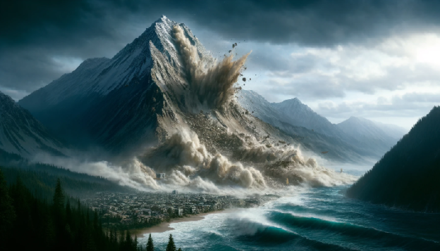
In 1970, a major earthquake (magnitude 7.7) in Peru caused a massive collapse of the summit of Mount Huascaran in the Andes. The large amount of rock and ice (about 100 million cubic metres) that fell from the mountain flowed down for about 14.5 kilometres at more than 300 kilometres per hour. This flow over a 230-meter-high ridge covered the town of Yungai, with a population of 25,000, in a 5-meter-thick layer, killing around 15,000 people.

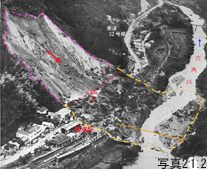
Meanwhile, in Japan, a 6.8-magnitude earthquake in 1984 in western Nagano Prefecture caused the collapse of some 36 million cubic metres of earth and rock at Kiso-Ontake; in 1792, Mount Unzen-Mayuma probably collapsed in an earthquake, causing some 340 million cubic metres of rock to collapse and flow into the Ariake Sea, causing a tsunami of up to 23 metres.

In an ordinary landslide, the coefficient of friction that indicates the distance and speed at which rocks and soil move is around 0.5, but in a particularly large debris avalanche, this can drop to 0.1 and move much further and faster. Large volcanoes are more prone to such large landslides because of the instability of their internal structure.

Source:

https://dil.bosai.go.jp/workshop/2006workshop/gakusyukai12.html

Day_199 : Early Signs of Geological Changes Before Landslides

Before significant landslides occur, various clear natural changes are often observed. Notable incidents include the 1963 Vajont Dam landslide in Italy and the 2006 Leyte Island landslide in the Philippines.

On the evening of October 9, 1963, a massive landslide took place near the Vajont Dam in the Alps of northern Italy. The dam, standing at 262 meters, was completed just three years prior. The landslide dislodged approximately 260 million cubic meters of earth, thrusting up the waters of the dam’s lake. The displaced water surged over the dam, rising more than 100 meters before rushing down into the valley below, resulting in approximately 2,000 fatalities. The geological layers in the area were unstable, compounded by the increased water levels from the dam. A minor landslide had previously occurred in 1960, and the landslide’s progress accelerated to several tens of centimeters per day just before the disaster. Despite ongoing monitoring, the catastrophic damage could not be prevented.

Day_140 : Natural Disasters in Europe (2) Vajont Dam Collapse


On February 17, 2006, a mountain 800 meters tall on the Philippine island of Leyte succumbed to a vast landslide, displacing around 20 million cubic meters of soil and claiming 1,144 lives. Before the collapse, cracks had appeared on the mountain’s ridge, and rainfall had begun to seep into the ground.

Identifying these early signs of geological change is crucial. By monitoring their progression and predicting potential danger zones, we can enhance our preparedness and safeguard our lives against such devastating natural disasters.

Contents (in Japanese)
Source: URL:https://dil.bosai.go.jp/workshop/2006workshop/gakusyukai21.html


What causes a landslide?


Day_196 : The Matsushiro Earthquake Center

The following is a reprint of a column I once wrote:

The Matsushiro Earthquake Center, nestled in the historic town of Matsushiro within Nagano Prefecture, represents a pivotal chapter in Japan’s approach to seismic research and disaster mitigation. Established in February 1967 under the auspices of the Japan Meteorological Agency’s Seismological Observatory, this institution was born out of a critical period marked by intense seismic activity. Between August 3, 1965, and April 17, 1966, the region experienced a staggering 6,780 seismic events, ranging from imperceptible tremors to significant quakes measuring intensity 5 and 4 on the Japanese scale. This unprecedented series of earthquakes not only posed a major societal challenge but also catalyzed the center’s founding.

The initiative to establish the center was strongly influenced by the then-mayor of Matsushiro, Nakamura, who famously prioritized the pursuit of knowledge and research over material wealth. This sentiment laid the groundwork for what would become a crucial site for earthquake prediction and disaster preparedness efforts, situated on the historical grounds of the Imperial Headquarters.

Drawing from my experience at the Natural Disaster Information Office and in collaboration with the Precise Earthquake Observation Office of the Japan Meteorological Agency (now known as the Matsushiro Earthquake Observatory), I have had the unique opportunity to organize and delve into discussions from that era. Despite being born after the seismic events in Matsushiro, I find the archival records fascinating. They not only recount the collective efforts of Matsushiro’s residents to forge a disaster-resilient community in the aftermath of the earthquake but also highlight the comprehensive nature of the research conducted.

The inquiries extended beyond seismic analysis, encompassing a holistic examination of the earthquake’s impact on the community. Noteworthy is the health survey conducted on students from a local school, in collaboration with the Matsushiro Health Center and hospital, to assess the psychological and physical effects of the seismic swarms. Moreover, the scope of investigation included studies on earthquake-induced landslides and the repercussions on water infrastructure, showcasing the multifaceted response from various experts and frontline workers of the time.

This rich tapestry of collective memory and scientific inquiry underscores the enduring spirit of Matsushiro—a community united in its commitment to disaster resilience, informed by the lessons of its past.

Ref.

http://researchmap.jp/read0139271/%E7%A0%94%E7%A9%B6%E3%83%96%E3%83%AD%E3%82%B0/

Day_145: Past Columns (in Japanese)

Past columns will be updated both in Japanese and English.

My past Japanese writings for an internet newspaper company and the research map researcher’s blog (Japan Science and Technology Agency’s site) can be checked in the following, but the article of the news company is not free and is not in English or Japanese.

http://www.nikkanberita.com/index.cgi?cat=writer&id=200507100351580

https://researchmap.jp/read0139271/%E7%A0%94%E7%A9%B6%E3%83%96%E3%83%AD%E3%82%B0/


Day_140 : Natural Disasters in Europe (2) Vajont Dam Collapse


europe-pic
Figure   The Europe

Concerning hydrological, meteorological, and climatological disasters, heavy rain and storm disasters are caused by low  pressure in the Icelandic area developed in the winter season. A cold atmospheric current coming from Arctic gains a warmer vapor stream from the Gulf Stream and develops a strong atmospheric depression in the area. This causes the strong winds and high tidal waves along the coastal areas of the North Sea. Netherlands and England can be highlighted. The Netherlands had storm surges in 1530 and 1570. The death tolls were approximately 400,000 (1530) and 70,000 (1570) for each. The 1953 depression took 1800 deaths. This disaster also reached England. England’s disasters were the 1703 Thames river flood and the 2003 Heatwave. The temperature was 8–10 over an average year in August 2003 (Day 38).

Danube, Elbe, Rhine, and Seine rivers are on a gentle slope, causing slow inundations caused by heavy rains. On August 2, 2002, Central Europe had heavy rain, which caused the Danube and Elbe rivers to overflow in Germany, Czech Republic, Austria, and Hungary. The death toll is approximately 100; the number of people affected is over 100,000. Historical buildings in the city, such as Prague,Dresden, and so on, along the rivers, were also inundated.

The Alps  have had landslides, debris flows, slope failures, and so on. The particular example is the landslide in the Dolomites, North Italy, in 1963. Overflows from Vajont dam caused by a large-scale landslide attacked the village in downstream areas. The death toll is approximately 2600.

A brief explanation


An interview-based explanation

On August 2003, West Europe had 8–10 degrees celsius higher than the average. This heat wave killed 15000 in France, 7000 in Germany, 4000 in Spain, 4000 in Italy, and so on, for a total of 35000.

In summer 2010, Russia had a heat wave and this makes wildfire. The wildfire was spread out and it took over 1.5 months to extinguish.Many villages were destroyed by the fire. Moscow was covered by harmful smoke. Over 55,000 people were killed by the heat wave and the smoke in Russia.

To be continued…

Day_99 : A Secondary Disaster- 1972 Shigeto Landslide Disaster

The Shigeto ward, Tosayamada town in Kochi prefecture had a huge landslide disaster on the 5th of July in 1972. We call it Shigeto Landslide.

What we can learn from this landslide is the secondary disaster.

First, a small landslide occurred at 6 am on the day. One volunteer firefighter was buried alive by the landslide. Other volunteer firefighters and local people started to conduct rescue work for him.

Second, a huge landslide happened at 10:55 am during their tasks and killed 59 among them. In addition, the landslide pushed the train stayed at Shigeto station away.

The following Figure 1 shows the landslide (NIED DIL)

shigetoupic
Figure 1 Shigeto Landslide