Vulnerability」カテゴリーアーカイブ

Day_200 : High-Speed Tsunamis and Delayed Warnings: The Urgency of Evacuation during the 1896 Meiji Sanriku, 1933 Showa Sanriku, and 2011 Great East Japan Earthquake and Tsunamis

Large tsunamis are caused by major earthquakes of magnitude 8 or greater. In particular, such earthquakes frequently occur along the Pacific coast of Hokkaido and Tohoku in Japan. The Sanriku coast in this region has a special shape called a “rias coast,” which is prone to tsunamis. In the 1896 Meiji Sanriku tsunami, the tsunami reached a height of 38 meters and killed about 22,000 people. Thirty-seven years later, in 1933, another major tsunami, the Showa Sanriku tsunami, struck the region, killing approximately 3,000 people. 2011’s Great East Japan Earthquake and Tsunami did not fully apply the lessons of the past, leaving approximately 18,000 people dead or missing.

The time between an earthquake and a tsunami reaching the coast is very short, from 5 to 10 minutes. Running to higher ground within this short time is almost the only way to protect yourself from a tsunami. The tsunami will reach the coast where it is the highest, and the tsunami will also reach the coast the fastest. Therefore, instead of waiting for information from the outside, it is important to have your own knowledge about tsunamis, understand your surroundings, and act on your own judgment.

Contents (in Japanese)
Source: URL:https://dil.bosai.go.jp/workshop/2006workshop/gakusyukai21.html

Day_196 : The Matsushiro Earthquake Center

The following is a reprint of a column I once wrote:

The Matsushiro Earthquake Center, nestled in the historic town of Matsushiro within Nagano Prefecture, represents a pivotal chapter in Japan’s approach to seismic research and disaster mitigation. Established in February 1967 under the auspices of the Japan Meteorological Agency’s Seismological Observatory, this institution was born out of a critical period marked by intense seismic activity. Between August 3, 1965, and April 17, 1966, the region experienced a staggering 6,780 seismic events, ranging from imperceptible tremors to significant quakes measuring intensity 5 and 4 on the Japanese scale. This unprecedented series of earthquakes not only posed a major societal challenge but also catalyzed the center’s founding.

The initiative to establish the center was strongly influenced by the then-mayor of Matsushiro, Nakamura, who famously prioritized the pursuit of knowledge and research over material wealth. This sentiment laid the groundwork for what would become a crucial site for earthquake prediction and disaster preparedness efforts, situated on the historical grounds of the Imperial Headquarters.

Drawing from my experience at the Natural Disaster Information Office and in collaboration with the Precise Earthquake Observation Office of the Japan Meteorological Agency (now known as the Matsushiro Earthquake Observatory), I have had the unique opportunity to organize and delve into discussions from that era. Despite being born after the seismic events in Matsushiro, I find the archival records fascinating. They not only recount the collective efforts of Matsushiro’s residents to forge a disaster-resilient community in the aftermath of the earthquake but also highlight the comprehensive nature of the research conducted.

The inquiries extended beyond seismic analysis, encompassing a holistic examination of the earthquake’s impact on the community. Noteworthy is the health survey conducted on students from a local school, in collaboration with the Matsushiro Health Center and hospital, to assess the psychological and physical effects of the seismic swarms. Moreover, the scope of investigation included studies on earthquake-induced landslides and the repercussions on water infrastructure, showcasing the multifaceted response from various experts and frontline workers of the time.

This rich tapestry of collective memory and scientific inquiry underscores the enduring spirit of Matsushiro—a community united in its commitment to disaster resilience, informed by the lessons of its past.

Ref.

http://researchmap.jp/read0139271/%E7%A0%94%E7%A9%B6%E3%83%96%E3%83%AD%E3%82%B0/

Day_182: The Prospects of “Natural” Disasters and Worldwide Readiness

Various strategies can be implemented to alleviate the impact of natural calamities. These encompass measures for reducing the impact of disasters, such as enhancing the ability of infrastructure to withstand damage, establishing systems that provide advance notice of potential disasters, and fostering education and knowledge about disasters.
Furthermore, implementing sustainable development strategies can also contribute to the mitigation of susceptibility to catastrophes. This includes the safeguarding and rejuvenation of natural ecosystems, which can function as innate safeguards against calamities.
The trajectory of natural calamities remains unpredictable. As climate change intensifies, we can anticipate a rise in the frequency and intensity of weather-related catastrophes. Nevertheless, by enhancing comprehension and preparedness we may alleviate their effects and construct a more robust environment.
Addressing natural disasters necessitates a synchronized, worldwide effort due to their global nature. Through comprehending the origins and consequences of disasters, as well as applying efficient solutions for disaster management, we may mitigate the effects and guarantee a more secure and adaptable future for everyone.

Day_177: Earthquake Preparedness and Response: Lessons from Turkey’s Seismic History

Image Source: FreeImages

The recent severe earthquake in Turkey has caused significant suffering throughout the country. This catastrophe serves as a stark reminder that natural disasters are far from ordinary occurrences. It is essential for us to learn and grow from each experience, not only within the affected country but also on a global scale. The article discusses Turkey’s earthquake history and how the nation has implemented lessons learned from past events. This analysis highlights the importance of continuous learning in order to better prepare for and respond to such disasters.

Introduction to Turkey’s seismic history

Turkey, a country bordering Europe and Asia, has suffered earthquakes before. It is incredibly vulnerable to these disasters because of its location on the seismically active Anatolian Plate. Turkey has historically seen some of the most damaging earthquakes in the world. Understanding the nation’s seismic history and drawing from its experiences can teach other countries valuable lessons on preparing for and responding to earthquakes.

A better understanding of how to predict, prepare for, and respond to these catastrophes has been made possible by the terrible impacts of earthquakes on Turkey. The country’s response plans have improved, using new engineering innovations and construction techniques to reduce casualties and property damage. In this post, we will examine Turkey’s seismic past, the significance of Adobe architecture there, and the lessons we can draw from Turkey to improve our readiness for and response to earthquakes.

Understanding earthquakes: Causes and types

Energy is released during the shifting and grinding of tectonic plates, which results in earthquakes. Large plates that make up the Earth’s crust are constantly moving and can collide, divide, or slide past one another, which can cause the ground to shake. Tectonic, volcanic, and induced earthquakes are the three main categories of earthquakes. The movement of the Earth’s plates causes the most frequent earthquakes, known as tectonic earthquakes. While induced earthquakes are brought on by human activity, like the mining of natural resources or the construction of huge reservoirs, volcanic earthquakes are brought on by the flow of magma beneath the Earth’s surface.

The Anatolian Plate, which is being compressed between the Eurasian and Arabian Plates, is Turkey’s leading cause of seismic activity. This tectonic activity has created numerous fault lines nationwide, making it vulnerable to earthquakes. For instance, the North Anatolian Fault, a strike-slip fault with a length of more than 1,000 kilometers, has caused multiple disastrous earthquakes in Turkey’s history.

The Significance of Adobe Structures in Turkey

Turkish architecture has long used adobe constructions built of soil mixed with straw or other organic materials. These constructions, frequently seen in rural locations, have served as fortifications, houses, and public facilities. The key benefits of Adobe structures are their affordability, simplicity, and great thermal qualities, which assist in maintaining a comfortable interior temperature all year round.

However, regarding seismic activity, Adobe constructions also suffer from serious drawbacks. These structures are particularly prone to collapsing during earthquakes because of their weight and low tensile strength. Throughout Turkey’s history, many large earthquakes have painfully illustrated this susceptibility, resulting in the death of countless people and extensive destruction.

Due to this, Turkey’s rising focus is on enhancing the seismic performance of Adobe structures. Researchers and engineers have been working on developing innovative techniques and materials to increase the earthquake resistance of these traditional structures and preserve their cultural relevance while ensuring the safety of their occupants’ safety.

Major earthquakes in Turkey’s history and their impact

Throughout its history, Turkey has been the site of many large earthquakes, some of which have had devastating effects. The Erzincan earthquake in 1939, the Izmit earthquake in 1999, and the Van earthquake in 2011 are three of the most famous. These seismic occurrences resulted in extensive property damage and fatalities and changed the nation’s strategy for earthquake preparedness and response.

Approximately 33,000 people perished in the 7.9-magnitude earthquake that struck Erzincan in 1939, and many more were injured or left homeless. This catastrophe made it clear that better seismic monitoring, prediction, and earthquake-resistant building techniques are required.

With nearly 17,000 fatalities and more than 50,000 injuries, the 1999 Izmit earthquake, which registered a 7.6 on the Richter scale, was among the deadliest and most catastrophic in modern Turkish history. The significant destruction brought on by this incident highlights the significance of strengthening earthquake preparedness and response strategies.

The most recent earthquake, the 7.1 magnitude Van earthquake in 2011, significantly damaged the Adobe structures in the area, killing over 600 people and displacing thousands more. This catastrophe also emphasized the necessity for improvements in construction methods and supplies for Adobe to improve its seismic performance.

Earthquake preparedness: What we can learn from Turkey

Turkey’s earthquake experiences have taught the country important lessons about preparedness. Adopting strict building regulations that account for seismic risks is crucial to earthquake preparedness. Turkey has made tremendous progress in this area; as of present, the country’s building codes demand that buildings be built resistant to earthquakes.

The creation and upkeep of early warning systems is vital to earthquake preparedness. Turkey has made significant investments in seismic monitoring and early warning systems, which can give locals crucial information in the minutes before an earthquake. By giving people enough time to take refuge or flee dangerous structures, this early warning can help save lives and reduce damage.

Finally, vital elements of earthquake preparedness are public awareness and education. Turkey has put a lot of effort into informing its inhabitants about the dangers of earthquakes and the essential safety measures to follow in the case of one. These are examples of regular earthquake exercises in schools, public awareness campaigns, and the distribution of earthquake safety informational materials.

Building earthquake-resistant Adobe structures

Several important regions have been the focus of efforts to increase the seismic performance of Adobe structures in Turkey. To strengthen their tensile strength and earthquake resistance, old Adobe buildings have been reinforced with contemporary materials like steel or concrete. Concrete columns, reinforced Adobe bricks, or the installation of steel reinforcement bars can all be used to achieve this.

Another strategy is the creation of fresh construction methods that more evenly disperse seismic pressures across the building. Using adaptable hardwood frameworks, using seismic-resistant design concepts, or using cutting-edge materials like fiber-reinforced Adobe are a few examples of how to do this.

Turkish scientists and engineers are also looking into the possibility of enhancing the earthquake resistance of Adobe constructions by employing locally derived ecological materials. This includes using natural fibers to increase the tensile strength of Adobe bricks, such as hemp or straw.

Effective earthquake response strategies in Turkey

The tactics used in Turkey to respond to earthquakes have also been informed. The quick deployment of rescue teams to find and aid stranded or injured people is crucial to an effective earthquake response. Specialized search and rescue squads in Turkey have received funding for training and equipment, and they are frequently among the first to arrive in earthquake-affected areas.

The provision of temporary housing and other services to displaced populations is a vital component of the earthquake response. Turkey has established an effective system for disaster response, including pre-stocked emergency supplies and temporary housing that can be quickly distributed to impacted communities after an earthquake.

Finally, effective earthquake response requires coordinated efforts from national and local governments, non-governmental organizations, and international partners. In the wake of significant earthquakes, Turkey has shown the usefulness of such cooperation, with international aid frequently playing an essential part in the nation’s rebuilding efforts.

Public awareness and education on earthquake preparedness

As informed populations are more prepared to respond to devastating disasters, public awareness, and education are essential to earthquake preparedness. The dissemination of educational materials, public awareness campaigns, and integration of earthquake safety education into school curricula are just a few of Turkey’s steps to increase general understanding regarding earthquake preparedness and response.

The “Safe School Program” is one significant part of Turkey’s public awareness campaigns. Schools are assessed for their capacity to withstand earthquakes as part of this program, and any necessary adjustments are made to protect the safety of students and staff in the event of an earthquake. Regular earthquake exercises are another curriculum feature that aids in preparing children and teachers for seismic occurrences.

International Collaboration for earthquake preparedness and Response

Because earthquakes are worldwide in scope, successful earthquake preparedness and response depend on international cooperation. The establishment of uniform building norms, the exchange of seismic monitoring data, and the provision of aid for disaster response are just a few of the ways that Turkey has actively participated in worldwide initiatives to increase earthquake resilience.

The World Housing Encyclopedia, which attempts to offer details on the seismic performance of structures worldwide, is a key endeavor in this area. Turkey has contributed to this effort by offering important information on the seismic performance of its conventional Adobe structures.

Building a resilient future for Turkey and Beyond

Turkey’s earthquake experiences taught us essential lessons about preparedness and response. Turkey has made tremendous progress in lessening the effects of earthquakes on its population by enacting strict construction rules, creating early warning systems, and improving public awareness about earthquake safety.

Researchers and engineers are looking for new methods and materials to increase the seismic performance of conventional Adobe structures in Turkey, which is a continuous effort. These initiatives could significantly impact earthquake-prone areas worldwide where traditional building materials and techniques are still widely used.

Finally, increasing earthquake resilience globally requires global cooperation and knowledge sharing. By cooperating, nations can benefit from one another’s experiences and create plans to lessen the effects of earthquakes on their populations.

To sum up, Turkey’s seismic past warns about the significance of earthquake preparedness and reaction. We can create a more resilient future for ourselves and future generations by implementing the lessons discovered from Turkey’s experiences in our communities.

Day_165: Capacity, Coping Capacity, and Capacity Assessment

Based on the UNDRR, capacity, coping capacity, and capacity assessment are defined as follows:

Capacity is “the combination of all the strengths, attributes and resources available within an organization, community or society to manage and reduce disaster risks and strengthen resilience.” and also annotated, “capacity may include infrastructure, institutions, human knowledge and skills, and collective attributes such as social relationships, leadership and management”

Coping capacity is “the ability of people, organizations and systems, using available skills and resources, to manage adverse conditions, risk or disasters. The capacity to cope requires continuing awareness, resources and good management, both in normal times as well as during disasters or adverse conditions. Coping capacities contribute to the reduction of disaster risks.”

Capacity assessment is “the process by which the capacity of a group, organization or society is reviewed against desired goals, where existing capacities are identified for maintenance or strengthening and capacity gaps are identified for further action.”

We consider the capacity as a part of the vulnerability mentioned in the Press and Release (PAR) model. The capacity is examined as a coping capacity in the context of the disaster.

This means capacity is more changing, human-centered, government-related, and has timely measurement aspects compared to the other vulnerability factors.

As mentioned above, capacity is considered one of the vulnerability factors, and the vulnerability index can be analyzed based on the statistical data. However, the applicable capacity statistical data is difficult to determine and also difficult to obtain in Thailand. In addition, capacity cannot be measured well by the statistical data. They could be greatly influenced by social networks, past experience, and other factors. With this situation, the capacity assessment can be utilized not only to measure social vulnerability but also to visualize the risk by overlapping with hazard risk on the GIS. Also, capacity can be considered to be the key to examining resilience.

Day_163: PAR model : Hazard and Vulnerability (3)

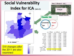
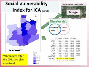
As discussed on Day 147, now we are investing the social vulnerability index of the district, sub-district, and village levels in Ayutthaya. To calculate the social vulnerability index, exposure, susceptibility, and capacity data are examined. Notably, the district level of the index is figured out, as shown in Figure 1, using principal component analysis.

(Please enlarge the screen to see the figure well. Darker blue means more vulnerable. The detailed factors of PCA will be explained later. )

Figure 1: Social Vulnerability Index Industrial Complex Area(SVI-ICA) Ref. 1)

https://disasterresearchnotes.site/archives/3746

As mentioned above, the district level of the social vulnerability index can be figured out by statistical data. However, sub-district and village levels data are challenging to collect. We also need to understand the capacity is a factor that includes not only hard but also soft countermeasures against natural disasters, as discussed before. Especially, capacity-soft is not stable by time with circumstances and could be changing from time to time. The stats data is not enough to indicate their actual capacities.

Based on the above fact, the capacity assessment is considered to fill the gaps. The capacity assessment method was based on the FDPI project experience.

The population of the target areas is indicated below:

Table 1:  The Population of the Tambons (Source: registration office 2019)

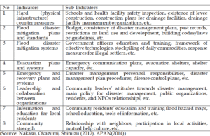
Below is the category (indicators) to measure the capacity.

Table 2: Indicators and Sub-Indicators for Capacity Assessment

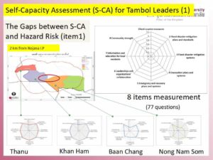
The results are as indicated in Figure 2.

Figure 2: Four Sub-District Capacity Assessment 

The findings show the western side and eastern side have a big gap, as you can see in Figure 2.

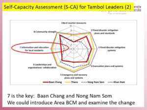
Figure 3 explains the education and training part is much different among the four target sub-district. The results mean we can monitor and evaluate their progress after we provide education, training, system, or so on there.

Figure 3: Capacity Assessment Analyses

For example, each sub-indicators are examined as follows:

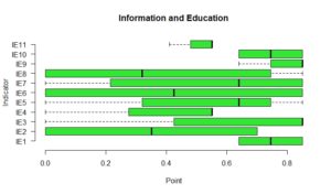
Figure 4: Information and Education Sub-Indicators Gaps 

The analyses (the detailed sub-indicators from IE1 to IE11) will be explained later.

Related Book and Info.

At Risk: Natural Hazards, People’s Vulnerability and Disasters

*This is the baseline research for the SATREPS project.

Day_159: PAR model : Hazard and Vulnerability (2)

http://disasterresearchnotes.site/archives/3746

As discussed on Day 147, now we are investing the social vulnerability index of the district, sub-district, and village levels in Ayutthaya. To calculate the social vulnerability index, exposure, susceptibility, and capacity data are examined. Especially, the district level of the index is figured out as shown in Figure 1 using principal component analysis.

Figure 1: Social Vulnerability Index Industrial Complex Area(SVI-ICA) Ref. 1)

The district level of the social vulnerability index can be figured out by statistical data. However, sub-district and village level data should be difficult to collect such data. Based on the fact, the capacity assessment is firstly conducted to the target four sub-districts as indicated in Figure 2. The capacity assessment method was based on the FDPI project experience.

Figure 2: Four Sub-District Capacity Assessment 

The findings say the western side and eastern side have a big gap as you can see in Figure 2.

Figure 3 indicates the education and training part is much different among the four target sub-district. This means we can monitor and evaluate their progress after we provide education, training, system, or so on there.

Figure 3: Capacity Assessment Analyses

The detailed examination will be explained later.

*Exposure, Susceptibility, and Capacity data list will be shown later. The theoretical frame is base on the PAR model. The below book can be referred.


At Risk: Natural Hazards, People’s Vulnerability and Disasters

**This is the baseline research for the SATREPS project.

Ref. 1) Tadashi Nakasu, Ruttiya Bula-or, Sutee Anatsuksomsti, Korrakot Positlimpakul (2019)Social Vulnerability Changes and Sustainable Development in the Flooded Industrial Complex Area The 2nd multidisciplinary International Conference on Humanities (ICH 2019) “Innovation and Transformation in Humanities for a Sustainable Tomorrow.” 30-31 October 2019, School of Humanities, Universiti Sains Malaysia, Penang, Malaysia

Day_147: PAR model : Hazard and Vulnerability

Disaster researchers often refer to the PAR (Press and Release) model to understand the risk.
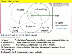
The PAR model was described in the book “At Risk”. This book is a kind of bible for disaster researchers. Disaster Risk is described as an overlapped area between Hazard and Vulnerability.


The Disaster risk should also consider “Exposure” and “Capacity”. The capacity has mainly two parts, Hard and Soft. In short, Capacity Hard (CH) means tangible factors and  Capacity Soft(CS) means intangible ones. For instance, infrastructure is CH and education is CS. The Disaster risk usually can be identified by the following picture. Figure 1 indicates the above.


Figure 1  Disaster Risk

Using the below equation, disaster risk would be identified.

Disaster Risk = H*E*V/ (CH+CS)

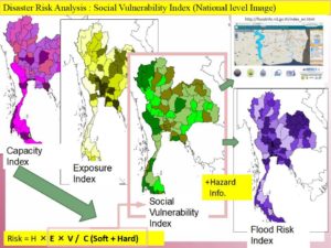
Each factor such as E (Exposure) could be identified by mainly statistic data in the target area.
To do this, the indices can be established. The data to contribute each factor should be carefully examined.

Figure 2 is the national level Index Image of Thailand.


Figure 2 Social Vulnerability

To be continued…..

Day_66 : Disaster Books At Riks, Measuring Vulnerability, and Disaster Theory (2)

The following books are very useful to understand disasters.
1. At Risk: Natural Hazards, People’s Vulnerability, and Disasters
2. Measuring Vulnerability to Natural Hazards: Towards Disaster Resilient Societies
3. Disaster Theory

1. “At risk” was already mentioned.


At Risk: Natural Hazards, People’s Vulnerability and Disasters

2. Birkman’s Measuring Vulnerability to Natural Hazards. This book is really really useful to understand the vulnerability of disaster research perspectives. The first, we can recognize what the vulnerability is. The second, this clarifies the vulnerability based on the people living in the areas. So the book divided the chapters or sections by the national, local, and community level. A brief explanation is found in the UN websites. An attached url also can be referred. This helps us to understand the Index, indices, and Indicators related work, which is internationally renown.


Measuring Vulnerability to Natural Hazards: Towards Disaster Resilient Societies

However, I also notice the vulnerability is one of the western thinking words facilitated by UN or developed countries. These kinds of “popular words” sometimes stop us to think the true meanings and the question of why this becomes popular. To avoid this, we can read these kinds of books from various perspectives.

3.Disaster Theory is very important to grasp the whole picture of what is the disasters and related terminologies. This book taught me a lot.


Disaster Theory: An Interdisciplinary Approach to Concepts and Causes (English Edition)