Disaster Preparedness」カテゴリーアーカイブ

Day_93: Natural disasters in Thailand – National Disaster Risk Assessement Mapping

Day_18 mentioned, “More must be done to fight climate change” (Bangkok Post)

https://disasterresearchnotes.site/archives/2304

The national risk assessment mapping in Thailand is briefly explained below.

Table 1  Disaster data in Thailand
em-dat_thailand
The target period of these EM-DAT data is from 1900 to 2014. However, the large numbers of deaths, affected people, and damage costs caused by natural disasters are all after the 1970s, as shown in Table 1. The data clarify that the 2004 Indian Ocean Tsunami and the 2011 Chao Phraya River flood disasters have been very influential in Thailand.

riskmapping_thailand
Figure 1 National Risk Assessment Mapping in Thailand

Figure 1 was created using EM-DAT data from Thailand (1900-2014). This risk assessment mapping (Frequency-Impact by each damage type) is very simple, but it allows us to easily grasp the whole picture of the risks.

The following risk matrix options help evaluate each risk.
riskoption1
Figure 2 Risk matrix options (1)

riskoption2
Figure 3 Risk matrix options (2)

From Figure 1, it is clear that the flood is the disaster that requires the most countermeasures in Thailand. Figures 2 and 3, for example, show that extensive management and monitoring are essential, and immediate action must be taken against the floods.

The above explanations are very rough. Detailed descriptions will be discussed later.

The above was already published with explanations as a report for the Japanese Association for Earthquake and Engineering (JAEE).

Day_55 : Tsunami Surveys in Hawaii

After the Indian Ocean Tsunami in 2004, we started collecting information on the tide gauge records around the Indian Ocean. In 2008, we also discussed the emergency management aspects for future possible tsunamis in the Indian Ocean at Pacific Tsunami Warning Center (PTWC)*, International Tsunami Information Center**(ITIC), and Univ. of Hawaii Sea Level Center(UHSLC)***.

*Pacific Tsunami Warning Center
We can confirm the present tsunami warning information.
The PTWC is the world’s core center for tsunami warnings.
As you may know, the tsunami is a Japanese word. The name comes from the Hiro village (many Japanese settlers lived there) in Hawaii, severely affected by the tsunami in 1968. The villagers called the wave “Tsunami.”

DSCN0457

**International Tsunami Information Center
They have important historical tide gauge records.

***University of Hawaii Sea Level Center
http://uhslc.soest.hawaii.edu/
We can confirm the sea level is rising around the globe.

Extra……..(^^)

The famous Hitachi company’s symbol image tree in Hawaii was found.

DSCN0464

Day_157: Disaster Warning (1)

I will update a column of the NIED e-mail magazine I wrote long ago because the content does not fade with time. (I will do this step by step in Japanese and English.) I will also add comments to update the situation.

Sorry, I am now revising this post because of the translation difficulties. This post will be revised again. Thank you.

Published May 6, 2010
NIED-DIL e-mail magazine: Disaster Warning (1)

■ Disaster Warning (1) ■

In February 2008, a survey provided an opportunity to visit Hawaii’s Pacific Tsunami Warning Center (PTWC). In a study, I interviewed the director of the PTWC, and the first thing that caught my attention was the role of the media. The director told me that a public tsunami evacuation alert was required three hours before the event, which was too time-sensitive, but the press was an advantage to do this. However, there were various restrictions for the government organization, such as warnings in an international framework. I remembered the Chilean Navy’s disaster response to the damage caused by the earthquake and tsunami in Chile in February this year.

Next, I was interested in science, technology, and data, which are the basis of alarm decisions. I think regular (flood, etc.) warnings will be judged based on current and past data, but especially for tsunami warnings, there were errors in the original earthquake and the tide gauge data. To judge, we should know that 99.99 percent of the errors could be caused by error. The fact that past data is not very useful because the devices to figure out the data are changing daily, making it difficult to rely on it.

From these facts, it was generally noticed that the disaster warning was based on the combination of the progress of science and technology and the competence of the person in charge. The actual warning also relies on the institution belonging to it. For example, variables such as the recipient of the alert, the psychology of the local people, the social situation, and various systems also needed to be added.

Issued May 6, 2010 No. 4

Day_196 : The Matsushiro Earthquake Center

The following is a reprint of a column I once wrote:

The Matsushiro Earthquake Center, nestled in the historic town of Matsushiro within Nagano Prefecture, represents a pivotal chapter in Japan’s approach to seismic research and disaster mitigation. Established in February 1967 under the auspices of the Japan Meteorological Agency’s Seismological Observatory, this institution was born out of a critical period marked by intense seismic activity. Between August 3, 1965, and April 17, 1966, the region experienced a staggering 6,780 seismic events, ranging from imperceptible tremors to significant quakes measuring intensity 5 and 4 on the Japanese scale. This unprecedented series of earthquakes not only posed a major societal challenge but also catalyzed the center’s founding.

The initiative to establish the center was strongly influenced by the then-mayor of Matsushiro, Nakamura, who famously prioritized the pursuit of knowledge and research over material wealth. This sentiment laid the groundwork for what would become a crucial site for earthquake prediction and disaster preparedness efforts, situated on the historical grounds of the Imperial Headquarters.

Drawing from my experience at the Natural Disaster Information Office and in collaboration with the Precise Earthquake Observation Office of the Japan Meteorological Agency (now known as the Matsushiro Earthquake Observatory), I have had the unique opportunity to organize and delve into discussions from that era. Despite being born after the seismic events in Matsushiro, I find the archival records fascinating. They not only recount the collective efforts of Matsushiro’s residents to forge a disaster-resilient community in the aftermath of the earthquake but also highlight the comprehensive nature of the research conducted.

The inquiries extended beyond seismic analysis, encompassing a holistic examination of the earthquake’s impact on the community. Noteworthy is the health survey conducted on students from a local school, in collaboration with the Matsushiro Health Center and hospital, to assess the psychological and physical effects of the seismic swarms. Moreover, the scope of investigation included studies on earthquake-induced landslides and the repercussions on water infrastructure, showcasing the multifaceted response from various experts and frontline workers of the time.

This rich tapestry of collective memory and scientific inquiry underscores the enduring spirit of Matsushiro—a community united in its commitment to disaster resilience, informed by the lessons of its past.

Ref.

http://researchmap.jp/read0139271/%E7%A0%94%E7%A9%B6%E3%83%96%E3%83%AD%E3%82%B0/

Day_195 : Scientists and Disaster Management Controversy issues with a L’Aquila Earthquake Case

The L’Aquila earthquake, which struck the Abruzzo region of Italy on April 6, 2009, was a significant case study for both scientists and disaster risk management professionals for several reasons. With a magnitude of 6.3, this earthquake caused extensive damage to the medieval city of L’Aquila, resulting in the deaths of more than 300 people, injuring over a thousand, and leaving tens of thousands of people homeless. Beyond the immediate physical damage and tragic loss of life, the L’Aquila earthquake raised important issues related to earthquake prediction, risk communication, and the responsibilities of scientists and authorities in disaster risk management.

Scientific Aspects and Controversies

The occurrence of earthquakes sparked a controversial debate over the ability to predict earthquakes and the communication of seismic risks to the public. Before the earthquake, a series of tremors were felt in the region, leading to heightened public concern. A week before the major earthquake, a meeting of the Major Risks Committee, which included government officials and scientists, was held to assess the situation. The committee concluded that it was not possible to predict whether a stronger earthquake would occur but reassured the public, suggesting a low likelihood of a major event. Unfortunately, the devastating earthquake struck shortly thereafter.

This situation has led to significant controversy, particularly regarding the role and communication strategies of scientists and government officials in disaster risk management. Critics argued that reassurances were misleading and contributed to a false sense of security among the population.

Legal and Ethical Issues

In a highly controversial decision, six Italian scientists and one government official were initially found guilty of manslaughter in 2012 for underestimating the risks and failing to adequately warn the population. This verdict was widely criticized by the international scientific community, which argued that it was unreasonable to expect scientists to accurately predict earthquakes. The verdict was largely overturned in 2014, with the convictions of scientists being annulled and the sentence of the government official being reduced.

Disaster Risk Management Implications

The L’Aquila earthquake underscored the importance of effective disaster-risk management and communication strategies. Key lessons include:

  1. Communication of Uncertainty: It highlighted the need for clear communication of scientific uncertainty to the public. Conveying the inherent uncertainties in earthquake prediction is crucial for helping individuals and communities make informed decisions about risk reduction and preparedness.
  2. Public Education and Preparedness: The tragedy reinforced the need for ongoing public education on disaster preparedness and the importance of building earthquake-resilient communities.
  3. Building Codes and Urban Planning: Ensuring strict adherence to earthquake-resistant building codes and urban planning practices is vital in reducing the vulnerability of buildings and infrastructure.
  4. Multi-disciplinary Approach: The event demonstrated the importance of a multi-disciplinary approach that includes not only seismologists but also engineers, urban planners, emergency management professionals, and policymakers in disaster risk management planning and response.
  5. Ethical Responsibilities: The aftermath raised questions about the ethical responsibilities of scientists and the balance between preventing public panic and ensuring preparedness.

The L’Aquila earthquake remains a case study of the complex interplay among science, policy, ethics, and public communication in the context of natural disaster risk management.

Day_85 : Shingen Embarkment: SAMURAI Disaster Risk Management

Those who can rule the water can also rule the country. This proverb became a reality, especially during the Sengoku period (Warring States Period) in Japan.

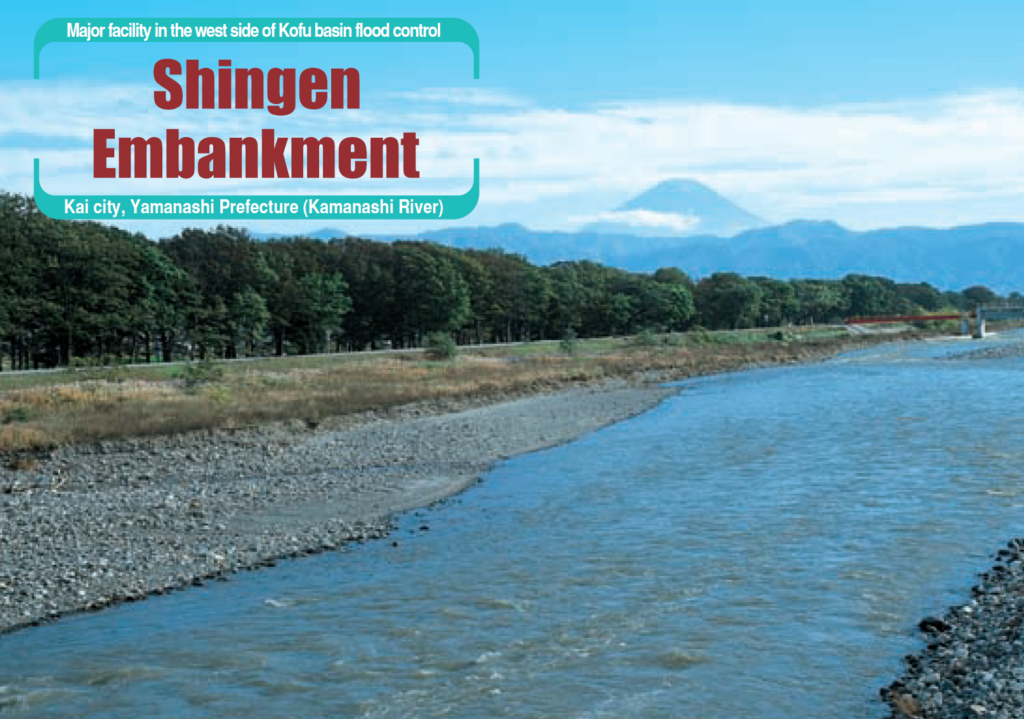
Shingen embankment was a flood control system built over 400 years ago to protect the northern part of the Kofu Basin, the rich rice paddy areas of Kai Province, then under the rule of Daimyo (District Lord) Shingen Takeda. The main problem is that the Midai River, a left branch of the Kamanashi River, is the major branch of the Fuji River, Once the Midai River flow increases and broke the bank protecting the Kofu Basin at its confluence with the Kamanashi River, the flood damage to the paddy fields was extensive. Such floods were known even in prehistoric times. Towards AD 1500, Shingen Takeda, the Daimyo (District Lord) of Kai country, directed that flood control works be made to protect the rice paddy area of his country (Takeuchi, 2003*).

Shingen Takeda was one of the strongest Samurai Daimyo (District Lord). He controlled his soldiers well and so did the floods.

shingenFigure: Shingen Embarkment**

*The Basis of Civilization: Water Science? (Proceedings of theUNESCO/IAMS/IWHA symposium held in Rome, December 2003). AI IS I’ubl. 286, 2004

**Brochure (Information about Fuji river Flood Control)

Day_36 : Disaster Scenario

A Disaster Scenario is one way to improve our disaster management skills. It is a kind of role-playing or simulation. Science can be applied to make the scenario more realistic. Disaster scenarios can be used at the personal or national level. We usually tend to have a normalcy bias; however, well-planned disaster scenarios can break such bias.

* Normalcy bias (Wikipedia)
We tend not to want to accept abnormal situations.

Day_188: Developing Flood Disaster Preparedness Indices (FDPI) for Thailand

The methodology involves a comprehensive approach to developing Flood Disaster Preparedness Indices (FDPI) for Thailand, with a focus on the cases of Ubon Ratchathani and Hat Yai. The FDPI was developed as a typhoon committee’s project as well as an ICHARM project. The outcome was polished, altered, and customized, and we are using the Indices as a selp capacity assessment tool.

Methodology

The development of Flood Disaster Preparedness Indices (FDPI) in Thailand was driven by a need for a standardized set of indicators that could assess the flood preparedness of local communities comprehensively. The methodology was designed to address the complexities of flood disaster management, acknowledging the balance between structural and non-structural measures (UNISDR, 2015) and the significance of community-based disaster risk management, especially in developing countries (Maskrey, 2011).

Literature Review and Theoretical Framework

An extensive literature review was conducted to understand the existing frameworks and measures used globally for evaluating disaster preparedness, with a particular emphasis on flood disasters. This review helped in identifying gaps in existing indices and provided a theoretical basis for developing a new set of indices that are universally applicable, considering both structural and non-structural elements of disaster risk management (Twigg, 2004; UNISDR, 2009).

Field Surveys and Data Collection

Field surveys were conducted in Bangkok, Ubon Ratchathani Province, and Hat Yai District, including interviews and questionnaire surveys. The surveys aimed to gather first-hand information on local disaster preparedness levels, community awareness, and existing infrastructure. This approach aligns with participatory methods recommended in disaster preparedness research, emphasizing local knowledge and engagement (Gaillard & Mercer, 2013).

Creation of Indices and Diagrams

Based on the literature review and field survey data, a comprehensive set of indices was created. The indices covered various aspects of disaster preparedness, from infrastructure and planning to community awareness and leadership. The creation of these indices was informed by best practices in disaster management literature, including the importance of comprehensive planning, community involvement, and the integration of local and scientific knowledge (Paton & Johnston, 2001; Cutter et al., 2008).

Analysis

The collected data were analyzed using principal component analysis and cluster analysis to identify key components of flood disaster preparedness and to categorize communities based on their preparedness levels. This analytical approach is consistent with methodologies used in similar studies, facilitating the identification of patterns and trends across diverse datasets (Jolliffe & Cadima, 2016).

Validation and Iteration

The FDPI was subjected to several rounds of validation, including expert reviews and community feedback sessions. This iterative process ensured the reliability and applicability of the indices across different communities, addressing the need for flexible and adaptable disaster preparedness tools (Few, 2007).

Source Papers

References:
1. Cutter, S. L., Boruff, B. J., & Shirley, W. L. (2008). Social vulnerability to environmental hazards. Social Science Quarterly, 84(2), 242-261.
2. Few, R. (2007). Health and climatic hazards: Framing social research on vulnerability, response, and adaptation. Global Environmental Change, 17(2), 281-295.
3. Gaillard, J. C., & Mercer, J. (2013). From knowledge to action: Bridging gaps in disaster risk reduction. Progress in Human Geography, 37(1), 93–114.
4. Jolliffe, I. T., & Cadima, J. (2016). Principal component analysis: A review and recent developments. Philosophical Transactions of the Royal Society A: Mathematical, Physical, and Engineering Sciences, 374 (2065), 20150202.
5. Maskrey, A. (2011). Revisiting Community-Based Disaster Risk Management. Environmental Hazards, 10(1), 42–52.
6. Paton, D., & Johnston, D. (2001). Disasters and communities: vulnerability, resilience, and preparedness. Disaster Prevention and Management: An International Journal, 10(4), 270–277.
7. Twigg, J. (2004). Disaster risk reduction: mitigation and preparedness in development and emergency programming. Humanitarian Practice Network.
8. UNISDR (2009). Terminology on Disaster Risk Reduction. United Nations International Strategy for Disaster Reduction.
9. UNISDR (2015). Sendai Framework for Disaster Risk Reduction 2015–2030. United Nations International Strategy for Disaster Reduction.This methodology reflects a comprehensive approach to developing a set of indices that can assess and enhance flood disaster preparedness at the community level. Through a blend of theoretical understanding, field research, and community engagement, the FDPI aims to contribute significantly to disaster risk reduction efforts in Thailand and potentially other similar contexts globally.

Day_186: Timeline for Hurricane Sandy

Moving forward, it is crucial that we continue to prioritize disaster management and invesin mitigation measures to minimize the impact of future disasters. This includes implementing resilient infrastructureconducting regular risk assessments, and engaging with communities to ensure their activparticipation in preparednesand recovery efforts. Additionally, we must continue to improve our communication strategies, utilizing various channels to disseminate timely and accurate information to the public. By learning from the lessons of Hurricane Sandy, we can strengthen our disaster management plans and better protect our communities in the face ofuture challenges.

Hurricane Sandy, which struck the East Coast of the United States in October 2012, is often cited as a case where disaster management and the use of a disaster management timeline played a crucial role in mitigating impacts and facilitating recovery. The response to Hurricane Sandy involved extensive pre-event planning and post-event recovery efforts that spanned the four phases of disaster management: mitigation, preparedness, response, and recovery.

1. Mitigation
Prior to Hurricane Sandy, New York had already invested in some mitigation measures based on lessons learned from previous storms, though the scale of Sandy’s impact highlighted the need for more extensive measures.

How New York Used Mitigation:
The city had begun to implement its PlaNYC initiative, aimed at preparing the city’s infrastructure for the impacts of climate change, including rising sea levels and more frequent severe weather events.

2. Preparedness
As Hurricane Sandy approached, New York’s state and city officials took several steps to prepare for the impending storm.

How New York Used Preparedness:
Evacuation Orders: Mandatory evacuation orders were issued for residents in low-lying areas, known as Zone A, affecting approximately 375,000 people.
Public Information: Information was disseminated through multiple channels, including social media, to keep the public informed about the storm’s progress and safety measures.
Transit Shutdown: The Metropolitan Transportation Authority (MTA) shut down subway, bus, and commuter rail services in anticipation of the storm to protect the system and its users.

3. Response
Once Hurricane Sandy made landfall, the response phase was immediate, with efforts focused on life-saving measures and ensuring the safety of the affected population.

How New York Used Response:
Emergency Services: First responders and emergency services worked tirelessly to rescue those stranded by the floodwaters and to provide immediate aid.
Power Restoration: Efforts were quickly organized to restore power to the millions of residents left in the dark.
Supply Distribution: Critical supplies, including food and water, were distributed to residents, especially in the hardest-hit areas.

4. Recovery
The recovery from Hurricane Sandy has been long-term, with efforts ongoing in some areas years after the storm.

How New York Used Recovery:
Rebuilding Infrastructure: Significant investments were made to rebuild and strengthen the city’s infrastructure, including electrical grids, transportation systems, and coastal defenses.
Resilience Planning: The storm’s impacts led to a heightened focus on resilience and the development of more robust plans to protect against future disasters, such as the “Rebuild by Design” competition that sought innovative solutions for coastal protection.
Community Support and Rebuilding: Efforts were made to support affected communities through the rebuilding process, including financial assistance for homeowners and businesses.

Lessons Learned and Implementation
The response to Hurricane Sandy highlighted the importance of preparedness and the need for robust mitigation and recovery planning. New York’s experience with Sandy has informed subsequent disaster management efforts, emphasizing the need for resilient infrastructure, comprehensive planning, and community involvement in disaster preparedness and recovery strategies.

The use of a disaster management timeline in the context of Hurricane Sandy demonstrated how proactive and reactive measures can mitigate the impact of such events and aid in the recovery process. It also showed the importance of continuous improvement in disaster management plans, incorporating lessons learned to enhance future preparedness and response efforts.

References:

Rosen, Y., & Yakubov, N. (2013). Hurricane Sandy: Lessons Learned from the Severely Damaged Coney Island Hospital, Prehospital and Disaster Medicine, 28(6), 643. https://doi.org/10.1017/S1049023X13008807

Barthel, E. R., Pierce, J. R., Speer, A. L., Levin, D. E., Goodhue, C. J., Ford, H. R., Grikscheit, T. C., & Upperman, J. S. (2013). Delayed family reunification of pediatric disaster survivors increases mortality and inpatient hospital costs: A simulation study. *Journal of Surgical Research*, 184(1), 430. https://doi.org/10.1016/j.jss.2013.05.040

Deitchman, S. (2013). Enhancing Crisis Leadership in Public Health Emergencies. Disaster Medicine and Public Health Preparedness, 7(5), 534. https://doi.org/10.1017/dmp.2013.88

Schmeltz, M. T., González, S. K., Fuentes, L., Kwan, A., Ortega-Williams, A., & Cowan, L. P. (2013). Lessons from Hurricane Sandy: A Community Response in Brooklyn, New York. *Journal of Urban Health*, 90(5), 799. https://doi.org/10.1007/s11524-013-9818-9

Freund, A., Zuckerman, N., Luo, H., Hsu, H.-H., & Lucchini, R. (2014). Diesel and Silica Monitoring at Two Sites Following Hurricane Sandy. *Journal of Occupational and Environmental Hygiene*, 11(9), D131. https://doi.org/10.1080/15459624.2014.916809

Solecki, W., & Rosenzweig, C. (2014). Climate Change, Extreme Events, and Hurricane Sandy: From Non-Stationary Climate to Non-Stationary Policy. *Journal of Extreme Events*, 01(01), 1450008. https://doi.org/10.1142/S2345737614500084

Johnson, D. A. (2023). Exploring the Effectiveness of 311 Data in Disaster Recovery and Response: A Case Study of Hurricane Sandy in New York City. *Academic Commons*. Columbia University. https://academiccommons.columbia.edu/doi/10.7916/p6h0-vp31

Petkova, E. P., Beedasy, J., Oh, E. J., Sury, J., Sehnert, E. M., Tsai, W.-Y., & Reilly, M. J. (2017). Long-term Recovery From Hurricane Sandy: Evidence From a Survey in New York City. (Disaster Medicine and Public Health Preparedness). https://doi.org/10.1017/dmp.2017.57

Federal Emergency Management Agency. (n.d.). Remembering Sandy Five Years Later. Retrieved from https://www.fema.gov

These references cover a range of topics related to the impact of Hurricane Sandy, including healthcare challenges, family reunification, crisis leadership, community responses, monitoring of environmental hazards, policy changes due to climate change, the effectiveness of using public data for disaster recovery, and long-term recovery challenges faced by residents.

Day_185:TImeline for Disaster Management

I wanted to share with you a brief overview of the timeline for disaster management. As someone with extensive experience in this field, I believe integrating this timeline with empirical insights from past disasters could further enhance the effectiveness of disaster management strategies.The timeline consists of four main phases: mitigation, preparedness, response, and recovery, based on the disaster management cycle. Mitigation focuses on reducing the impact of disasters through long-term measures. Preparedness involves planning and preparing to respond to a disaster. The response phase is activated when a disaster occurs, and the recovery phase focuses on restoring the affected community.Implementing the timeline requires collaboration and coordination, community involvement, and continuous improvement. By understanding and utilizing this timeline, disaster management professionals can effectively plan for and respond to disasters, ultimately reducing their impact on communities.

A timeline for disaster management typically outlines the chronological steps and phases involved in preparing for, responding to, and recovering from disasters. This timeline can be crucial for organizations, governments, and communities to manage the impacts of disasters efficiently. The timeline usually spans before, during, and after a disaster occurs and is divided into four main phases: mitigation, preparedness, response, and recovery. Here’s a brief overview:

1. Mitigation
Mitigation involves efforts to reduce the impact of disasters. This phase includes long-term measures aimed at minimizing or altogether avoiding the effects of disasters. Examples include building dams or levees to prevent flooding, enforcing building codes to withstand earthquakes, and implementing fire management strategies in wildfire-prone areas.

How to use:
Implement building and infrastructure standards that can withstand natural disasters.
Conduct environmental assessments and hazard analyses to identify risks and vulnerabilities.
Develop and enforce land-use policies that consider hazard-prone areas.

2. Preparedness
Preparedness focuses on planning and preparing to respond to a disaster. This phase involves training, exercises, establishing emergency plans, stocking supplies, and ensuring communication systems are in place.

How to use:
Conduct drills and exercises for emergency services and the public.
Develop and disseminate emergency plans, including evacuation routes and shelter locations.
Educate the community about disaster risks and how to prepare for them.

3. Response
The response phase is activated when a disaster occurs. It includes immediate actions taken to ensure safety, such as search and rescue operations, providing emergency services, and offering immediate relief to affected individuals.

How to use:
Activate emergency operations centers and disaster response plans.
Deploy emergency services and first responders to the affected areas.
provide emergency communications and information to the public.

4. Recovery
Recovery involves restoring the affected community to normal or better conditions. This phase can be short-term, focusing on immediate needs, or long-term, focusing on rebuilding and rehabilitation.

How to use:
Assess the damage and prioritize recovery efforts.
Support affected individuals and communities through rebuilding and financial assistance programs.
Review and revise disaster management plans based on lessons learned.

Implementing the Timeline
Collaboration and Coordination: Work with local, national, and international bodies to share information and resources.
Community Involvement: Engage the community in all phases to ensure that disaster management efforts are inclusive and meet the needs of all affected populations.
Continuous Improvement: Regularly review and update disaster management plans based on new information, technologies, and lessons learned from past events.

By understanding and utilizing this timeline, disaster management professionals can effectively plan for and respond to disasters, ultimately reducing their impact on communities.

A timeline can be derived from the disaster management cycle. The precise timetable for community disaster management is more specific, with intervals of two days, one day, three hours, during the disaster, and so forth.

In reference to:

What is the disaster management cycle?

What Is a Disaster Management Cycle?