Disaster Risk Reduction」カテゴリーアーカイブ

Day_168 : Past Interview Records – PTWC (Pacific Tsunami Warning Center) in Hawaii (1)

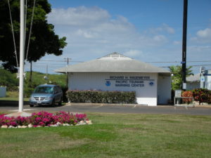
Continue to the past New Orleans Interview Records, I would like to open the memo about the interview to PTWC. It was a great time and I learned a lot from the interviews.  So I would like to share the fact to let you know their works to tackle the tsunami disasters in the world.

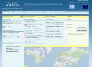
PTWC is the core center for the tsunami warning well known to the world.

2008.2.26 (Tue.) at 1000 am
15 staff, director, deputy director
Information Technician, including nine scientists
16-hour shift on 8-4-4, homes are next to the center

The records from the interview survey are shown below.

■ Evacuation
There is no international standard in terminology. Terminology varies by country/region. The words sometimes make me confused. Also, in the past, it was two either evacuation nor no evacuation.

■ Warning Error
It is challenging to give a warning. There are errors in the original earthquake and the tide data. There is an error in the gauge also.
To judge them collect is too hard. So, it can be said that 99.99% is an error.

In Hawaii, only a quarter of evacuation was actually damaged in the past. It is not unusual that although there were evacuations, there were no damages at all.

■ Past data and warning judgment
Only use a few. Because how to put out the past data, equipment, etc.are hard to do. Which way is the numerical model used to determine if the earthquake becomes a tsunami is complicated. There are more things to do.

■ Relationship with other countries
The countries that are most focused on warning about tsunami in the Pacific are Japan, America, Australia, Chile, Canada, and Russia. Also, it is not possible to evaluate the inspection records of other countries. This should be noted.

■ At the time of the 2004 tsunami
Most of the records before the Indian Ocean Tsunami were reported hourly, so judge the event was tough. Every 15 minutes, now every 6 minutes is normal and very good.

■ Conditions for cancellation
Make a comprehensive decision. The problem of reflections adds to the complexity. Not only direct waves but also an indirect wave should be considered.

Day_165: Capacity, Coping Capacity, and Capacity Assessment

Based on the UNDRR, capacity, coping capacity, and capacity assessment are defined as follows:

Capacity is “the combination of all the strengths, attributes and resources available within an organization, community or society to manage and reduce disaster risks and strengthen resilience.” and also annotated, “capacity may include infrastructure, institutions, human knowledge and skills, and collective attributes such as social relationships, leadership and management”

Coping capacity is “the ability of people, organizations and systems, using available skills and resources, to manage adverse conditions, risk or disasters. The capacity to cope requires continuing awareness, resources and good management, both in normal times as well as during disasters or adverse conditions. Coping capacities contribute to the reduction of disaster risks.”

Capacity assessment is “the process by which the capacity of a group, organization or society is reviewed against desired goals, where existing capacities are identified for maintenance or strengthening and capacity gaps are identified for further action.”

We consider the capacity as a part of the vulnerability mentioned in the Press and Release (PAR) model. The capacity is examined as a coping capacity in the context of the disaster.

This means capacity is more changing, human-centered, government-related, and has timely measurement aspects compared to the other vulnerability factors.

As mentioned above, capacity is considered one of the vulnerability factors, and the vulnerability index can be analyzed based on the statistical data. However, the applicable capacity statistical data is difficult to determine and also difficult to obtain in Thailand. In addition, capacity cannot be measured well by the statistical data. They could be greatly influenced by social networks, past experience, and other factors. With this situation, the capacity assessment can be utilized not only to measure social vulnerability but also to visualize the risk by overlapping with hazard risk on the GIS. Also, capacity can be considered to be the key to examining resilience.

Day_162: Disaster Links Library

As mentioned below, the Disaster Links Library has been created. The first draft is attached to this menu as “Disaster Links Library”. There are still many challenges ahead, however, the page will be completed step by step with adding more info.

If you have some excellent links, please let me know.

https://disasterresearchnotes.site/archives/3793

sponsored link

Day_160: Interview Report: Hurricane Katrina Response (1)

Now I am digging up my past experience. The report is a part of the project.

The below past article can be checked for your reference.

https://disasterresearchnotes.site/archives/2975

>>>>>>>>>>>>>>>>>>>>>>>>>>>>>>>>>>>>>>>>>>>>>>>>>>>

Date and time
7 May 2006

Visit
New Orleans Homeland Security and Public Safety Office
(New Orleans City Office of Homeland Security and Public Safety )

Interviewee
Colonel and Director

Subject
Hurricane Katrina Disaster Response

>>>>>>>>>>>>>>>>>>>>>>>>>>>>>>>>>>>>>>>>>>>>>>>>>>

<Contents>
< Work >
The interviewee: Responsible for the Police, fire, EMS (emergency medical services),
and crisis management of cooperation with state, federal and city

< The lessons of Katrina >
The lesson learned is, “We can not rely on external resources. Without relying on the federal (country) government, each person should think they need to protect themselves.” (This is the interview record.)

<Hurricane Katrina-What Happened>
Before Friday (8/26), all the state government was setting evacuation preparation. FEMA staff deployed throughout the city. Eighty percent of citizens evacuated on their own, but many of the rest were unable to evacuate with no means.

The city, about 15,000 civilians, were provided transportation means to be saved in the shelter. Besides, before hurricane landfall on Sunday(8/28), the people in the city who can not evacuate evacuated to Super Dome.

Since the federal government does not permit having a shelter in New Orleans, New Orleans is the only city ​​in the U.S. that does not have a shelter. The Federation and the Red Cross had considered the situation as a dangerous task because of this.

When the hurricane comes, Super Dome became a temporary shelter.

Picture: New Orleans City Hall (on 7 May 2006)

After the hurricane, we had a tough week. After all, approximately 700 people of citizens lost their lives.

Day_158: Disaster Warning (2)

I will update a column of the NIED e-mail magazine which I wrote a long time ago because the content is not faded with time. (I will do this step by step in Japanese and English) I will also add comments to update the situation.

Sorry, now I am revising this post because of the difficulties of the translation. This post will be revised again. Thank you.

Published June 4, 2010
NIED-DIL e-mail magazine: Disaster Warning (2)

■ Disaster Warning (2) ■

Following the tornado that hit Saroma in Hokkaido in November 2006, I was given the opportunity to visit Oklahoma in the United States in February 2007 for a survey on tornado disaster response, especially tornado disaster alerts. In particular, I visited mainly the NWC (National Weather Center) built inside the University of Oklahoma. At there, Professor Emeritus Yoshikazu Sasaki helped us. He is very famous for being a model of the Hollywood movie “Twister.” I learned that U of Oklahoma, especially a climatological course rapidly became competitive in the U.S. after the movie was released. In the movie “Twister,” there was a scene where cows were flying in the air, at NWC, there was a coffee shop called Flying Cow.

The most impressive thing about the visit was the recognition that the NWC needed a wide range of cooperation on tornado response and put emphasis on community awareness. Regarding multi-disciplinary collaboration, the reason behind this is that even if we increase the accuracy and speed from tornado prediction to warning by science and technology, it will be human beings that will respond to it. Also, there is an organization called the Warning Decision Training Branch (WDTB) <Warning Judgment Training Center> inside the university. The existence is based on the fact that the decision of warning (Warning Decision) is not only radar data, but also specialized in model guidance and mesoscale analysis in combination with the human mind. People, the Emergency Manager, make decisions based on a variety of factors, including technical knowledge and reports from spotters (registered volunteers who inform the situation on the spot). The local factors and political conditions are also overlapped. The knowledge of meteorology expertise alone could not attain the purpose.

As for local enlightenment activities, as a contribution to the community, create and publicize many brochures, open a center, for example, tie-up with McDonald’s in a program called McLeady and give educational advertisements was doing. In this way, the NWC recognizes that disaster alerts are based on various factors such as understanding of human behavior, bonding with society, and political situations, and it is common sense that meteorology alone cannot respond. It was impressive that it was done.

Issued June 4, 2010-Issue 5

https://disasterresearchnotes.site/archives/2553

Day_157: Disaster Warning (1)

I will update a column of the NIED e-mail magazine which I wrote a long time ago because the content is not faded with time. (I will do this step by step in Japanese and English) I will also add comments to update the situation.

Sorry, now I am revising this post because of the difficulties of the translation. This post will be revised again. Thank you.

Published May 6, 2010
NIED-DIL e-mail magazine: Disaster Warning (1)

■ Disaster Warning (1) ■

In February 2008, a survey provided an opportunity to visit the Pacific Tsunami Warning Center (PTWC) in Hawaii. In a study, I interviewed the director of the PTWC, and the first thing that caught my attention was the role of the media. The director told me that a public tsunami evacuation alert required three hours before the event, which was too time-sensitive, but the media was an advantage to do this. However, for the government organization, there were various restrictions, such as warnings in an international framework. I remembered the Chilean Navy’s disaster response to the damage caused by the earthquake and tsunami in Chile in February this year.

Next, I was interested in science, technology, and data that are the basis of the alarm decision. I think that normal (flood etc.) warnings will be judged based on current and past data, but especially for tsunami warnings, there were errors in the data of the original earthquake and the tide gauge. To do judge, we should know the 99.99 percent could be the error. The fact that the past data is not very useful because the devices to figure out the data are changing day by day, making it difficult to rely on it.

From these facts, it was generally noticed that the disaster warning was based on the combination of the progress of science, technology and the competence of the person in charge. The actual warning also relies on the institution belonging to it. For example, it was also needed to add variables such as the recipient of the alert, the psychology of the local people, social situation, and various systems.

Issued May 6, 2010 No. 4

Ref.

https://disasterresearchnotes.site/archives/2592

Day_156: Matsushiro Earthquake Center

I will update a column of the NIED e-mail magazine which I wrote a long time ago because the content is not faded with time. (I will do this step by step in Japanese and English.) I will also add comments to update the situation.

Published April 5, 2010
NIED-DIL e-mail magazine: Matsushiro Earthquake Center

■ Matsushiro Earthquake Center ■

There is an organization called Matsushiro Earthquake Center in Matsushiro, Nagano Prefecture, Japan. The Center was established in February 1967 at the Japan Meteorological Agency in Matsushiro Town, Nagano Prefecture (now Nagano City), based on the Matsushiro Seismological Observatory, which was established in 1947. The background of this establishment is that between August 3, 1965, and April 17, 1966, insensitive earthquakes with seismic intensities 5 and 4 were observed three times each and a total of 6,780 earthquakes were detected in the Matsushiro town area. This severe earthquake activity has become a major social problem.

It is famous that Mayor Nakamura at that time said that he wanted to learn and research more than things and money, and that was the starting point of the center. The center is also well known as the location where was planned to build the imperial general headquarters at the end of the second world war. Besides, It is known that the experience gained from the observation of the earthquake has dramatically influenced the progress of earthquake prediction and disaster countermeasures today.

The author is organizing the records of the discourse at the time with the cooperation of the Japan Meteorological Agency’s Earthquake Observatory (Matsushiro Seismological Observatory) as the Disaster Information Office. I am surprised at the fascinating records. The fact that Matsushiro city was working to build a disaster-resilient town in the wake of an earthquake throughout the city is well communicated. For example, there was not only research on the earthquake itself but also research on the health status of students, including psychological aspects from nearby schools caused by a swarm. This was due to the cooperation of Matsushiro health centers and hospitals. It does not stop there. Members were active in the front lines of various fields at the time, such as landslide surveys caused by earthquakes and the impact on water supply facilities during earthquakes, reports from various perspectives.

I am sorry that the format, etc. is still insufficient, but I am starting to release these records on the HP in hopes that you can see it in a provisional form. Please see if you have time.

URL: http://dil.bosai.go.jp/library/matsushiro/MRecord.html

Now you can not access it, but you can ask NIED DIL for information.

Published on April 5, 2010

Matsushiro Seismological Observatory
https://www.data.jma.go.jp/svd/eqev/data/matsushiro/en/index.html

Day_152 : (In Japanese) 災害による報告死者数

かなり前に書いたメールマガジンのコラムですが、内容は、色あせていないので、復習を兼ねて、これから数回にわたり掲載致します。(同様に英語版も順番に掲載していきます。)

2010年2月4日発行
再掲NIED-DILメールマガジン:1回】災害による報告死者数
■災害による報告死者数■

1月12日ハイチで大きな地震がありました。その影響は、現在でも大きな社会問題ともなっていますが、初期の段階で大統領が20万人の犠牲者が出ていると宣言しました。

2005年8月末のハリケーン・カトリーナ災害のときは、最初1万人との報道がなされましたが、最終的に1千3百人ぐらいになりました。死者が少ないのに越したことはありませんが、日本と比べてお国柄がこのようなところにもでるのかと感じます。

日本の場合で典型的な事例は、阪神・淡路大震災の時です。当時筆者は京都に住んでおり、京都市内で働いておりましたが、大きなゆれのあと、朝7時ごろは、死者の数がまだ数人だったとTVなどで報道されていたのを覚えています。それが時間が経つにつれて、数百人、数千人と時間が経つごとに増えていきました。

アメリカは、トップダウンで戦略的、日本は、ボトムアップで正確さ重視、そんな感じがします。2004年のインド洋津波では、周辺諸国の報告死者数が上下していましたが、この点をとっただけでも、災害がその国の経済や社会状況を浮き彫りにする一端が見えてきます。

ハイチに関しては時を追うごとに報告死者数が増えておりその状況が心配されます。初期の段階の大統領の宣言どおりの数字にならないことを祈ります。

2010年2月4日発行

P.S.

例えば下記のワールドビジョンのHPでは、現在の推定死者を、250,000人としています。つまり、最初の報告は最終的には、ある意味的を得ていたことになってしまいました。

https://www.worldvision.org/disaster-relief-news-stories/2010-haiti-earthquake-facts

Day_151 : Disaster Information 5

I had a query on historical earthquake information in Japan. Therefore, I update the new useful disaster information especially historical data in Japan.

The following is the archive of disasters (can select disaster type, year, and area) all over Japan but only in Japanese.
The archive was created to collect all local government data in Japan.
The best book to know the historical earthquake disaster record is the following book. This is also only in Japanese.


The followings are the same as the disaster information 4.

Flood list: an excellent source of flood disasters
floodlist.com/tag/thailand
AHA center- adinet: disasters in ASEAN countries can be browsed and also checked in detail.

DRH-Asia: cases on local knowledge and their applications related to the technologies in Asian countries can be found.
http://drh.bosai.go.jp/
The post of the disaster information 3 is the followings:
https://disasterresearchnotes.site/archives/3171
——

Introduced you to the following disaster information.
1) General info. 2) Database 3) Update info

1) General info is the first website to check.
1. UNISDR

unisdr

2) Database is the base to analyze the target disasters.
1. EM-DAT

emdat

2. Desinventar

disinventar

The disinventar is very accurate and detailed, however, the listed
countries are limited.

3) Update info. Is the website, we can check on a daily basis.
These are also useful to overview of the recent disasters.
1. ReliefWeb

reliefweb

2. ADRC

adrc

3. ROSE

ROSE

4. GDACS

GDACS

Concerning, data on demographic, socioeconomic, and others, we should
clarify the levels from national to local.

County Level
1. UN data

undata

2. World Bank open data

world bank data

3. CIA world factbook

world fact book

Provincial (States) Level
1. Government Office (National Statistics Office,etc.)

Community Level
1. Local Government Office
When we investigate the disasters, we first go to the ADRC (if the country is Asia) and Relief Web to see some significant numbers such as the death toll and affected numbers. Then, check the disaster history of the target areas by EM-DAT and Desinventar (if the country is listed). We also overview the county’s background by CIA world fact book and check some socio-economic data by UN or World bank open data. In addition, the local government or community data of the target area are significant to be accessed. These are the primary action to grasp the whole picture of the disaster.

Day_149: Flood Disaster Preparedness Indices (FDPI)

ICHARM (International Centre for Water Hazard and Risk Management) allowed me to engage in the project on the development of Flood Disaster Preparedness Indices (FDPI). This project is also linked to one of the projects of the Typhoon Committee (World Meteorological Organization/United Nations ESCAP).

You can see the outline of the project on the following website:.

http://www.apan-gan.net/adaptation-technologies/database/flood-disaster-preparedness-indices-fdpi

The established site is the self-evaluation system for local disaster managers around the world, especially in developing countries. Therefore, we have prepared the multi-language (16 languages) versions. You can evaluate your community’s preparedness ability by yourself, and experience can also be shared depending on your situation.  You can easily see your results on the website. The results are automatically sent to the administrator to check on the situation. If the administrator understands the severity, he or she can communicate with the international aid agencies.

http://www.fdpi.jp/fdpi/

To be continued…