Balancing Continuity and Survival: Lessons for Overseas Manufacturers from Thailand’s 2001 Flood

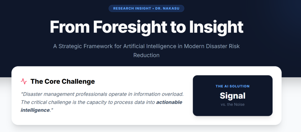
The infographic of the AI-Integrated Disaster Preparedness Platforms is shown as an infographic: AI-Integrated Disaster Preparedness Platforms
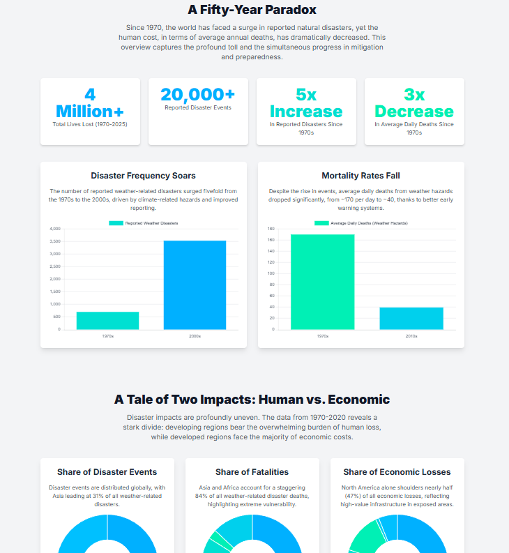
The infographic of the global trends of disasters (1970-2025) is shown as an infographic: https://disasters.weblike.jp/global%20trends.html
From Tragedy to Leadership: The Birth of ADRC
The Asian Disaster Reduction Center (ADRC) was established in 1998 following the devastating Great Hanshin-Awaji Earthquake (commonly known as the Kobe Earthquake) that struck Japan in 1995. This catastrophic event became a catalyst for change, transforming how Japan—and later Asia—approached disaster management and resilience.
Kobe’s Remarkable Recovery Journey
Kobe’s recovery story stands as a powerful testament to resilience and strategic rebuilding. Within just 9 years after the earthquake, Kobe’s population returned to pre-disaster levels—an extraordinary achievement considering the scale of destruction. This recovery wasn’t merely about rebuilding structures but reimagining the city’s future role.
HAT Kobe: A Hub for Disaster Reduction Excellence
Today, Kobe has reinvented itself as a global center for disaster reduction policies and activities. The area known as HAT Kobe hosts numerous disaster-related organizations, including ADRC. The name “HAT” carries dual significance:
This wordplay perfectly captures Kobe’s transformation from a disaster-struck city to a knowledge hub that helps others prepare for and respond to unexpected disasters.
Learning From Kobe: A Model for Disaster Recovery
Kobe’s recovery process offers valuable lessons for communities worldwide facing similar challenges. The city demonstrates how effective post-disaster planning can transform tragedy into opportunity, creating not just infrastructure but institutional knowledge that benefits others.
ADRC’s Mission Across Asia
ADRC plays a vital role in sharing disaster reduction expertise with its member countries throughout Asia. The organization:
Resources for Disaster Management Professionals
ADRC maintains comprehensive resources that disaster management professionals can access:
These resources provide valuable insights into regional disaster management systems, country-specific approaches, and up-to-date information on current disaster situations across Asia.
Building Regional Resilience Together
Through organizations like ADRC and the example set by Kobe, Asian countries are developing stronger collaborative approaches to disaster risk reduction. By learning from past experiences and sharing knowledge, communities across the region are better prepared to face future challenges with resilience and determination.
As highlighted in the Bangkok Post article, “More must be done to fight climate change“, Thailand faces significant challenges from various natural disasters. This analysis presents a national risk assessment mapping to help identify priority areas for disaster management.
Table 1 Disaster data in Thailand
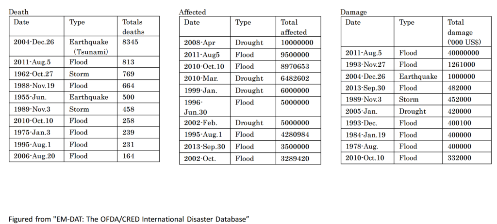
The EM-DAT database analysis covers disasters from 1900 to 2014. Notably, the most severe impacts—measuring deaths, affected populations, and economic damage—have occurred primarily since the 1970s. Two catastrophic events stand out in Thailand’s disaster history:
These events have dramatically shaped Thailand’s approach to disaster risk management.
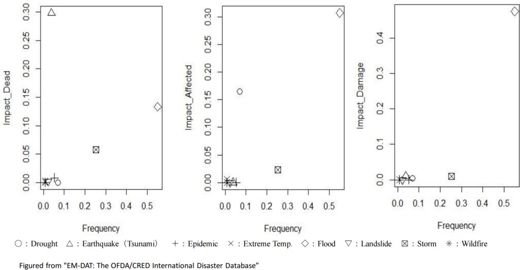
Figure 1 National Risk Assessment Mapping in Thailand
The above visualization presents Thailand’s risk assessment map created using EM-DAT data spanning 1900-2014. This frequency-impact analysis by damage type offers a straightforward yet comprehensive overview of Thailand’s disaster risk landscape.
To properly contextualize these risks, we employ two complementary evaluation matrices:
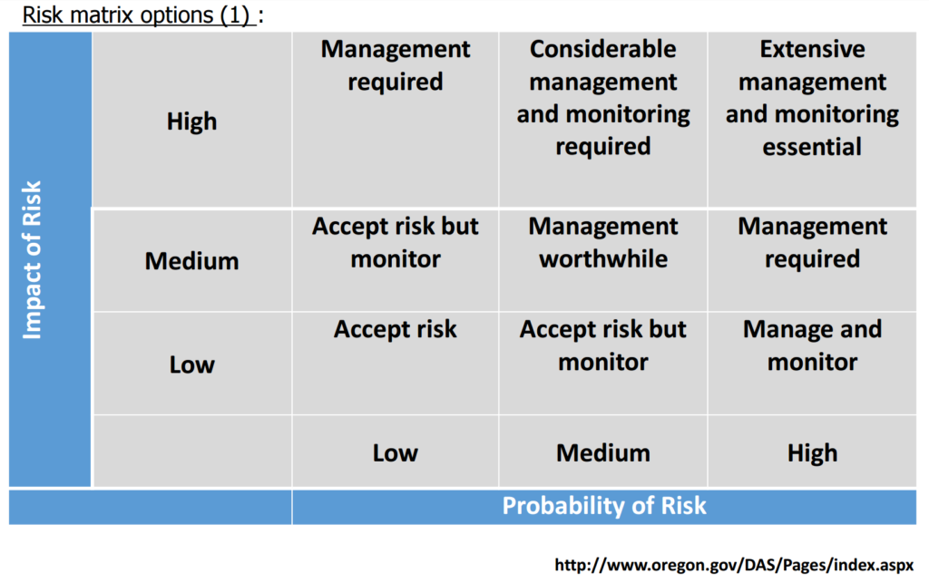
Figure 2 Risk matrix options (1)
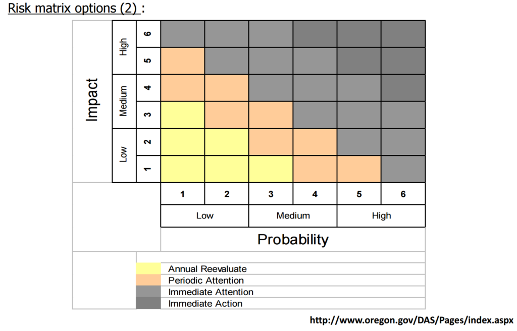
Figure 3 Risk matrix options (2)
The risk assessment mapping (Figure 1) clearly identifies flooding as Thailand’s most critical disaster risk requiring immediate attention and resources. According to the evaluation matrices shown in Figures 2 and 3, flood events necessitate:
This preliminary analysis serves as a foundation for more detailed research. A report for the conference (Conference: 13th International Conference on Thai Studies) has published a more comprehensive examination of these findings.
Additional Resources
For more information on disaster risk reduction in Southeast Asia, visit the natural hazards research journal (open access) .
Japan was vulnerable after the Second World War, so we had many natural disasters, especially Typhoon disasters, from 1945 to 1959. Some call this 15 years a great flood and storm era. The first hit was Typhoon Makurazaki on September 15, 1945*. The typhoon hit Hiroshima city. There were 1229 casualties in the city. This fact reminds us of what happened in Hiroshima in the same year. The atomic bomb hit Hiroshima city this August. We had no weather forecast system during the war because of military reasons. The people in Hiroshima were living in vulnerable houses because the bomb hardly hit them. They did not have enough information about the typhoon’s coming, either. Therefore, this typhoon disaster is a complex disaster consisting of natural, technological, and human-made disasters.
*Hiroshima Pref. Website:
http://www.bousai.pref.hiroshima.jp.e.bq.hp.transer.com/www/contents/1318849427179/index.html
http://www.pref.hiroshima.lg.jp.e.bq.hp.transer.com/soshiki/100/makurazaki.html
**A Blank in the Weather Map by Kunio Yanagida
https://en.wikipedia.org/wiki/A_Blank_in_the_Weather_Map

Large tsunamis are caused by significant earthquakes of magnitude eight or greater. In particular, such earthquakes frequently occur along the Pacific coast of Hokkaido and Tohoku in Japan. The Sanriku coast in this region has a unique shape called a “rias coast,” which is prone to tsunamis. In the 1896 Meiji Sanriku tsunami, the tsunami reached a height of 38 meters and killed about 22,000 people. Thirty-seven years later, in 1933, another major tsunami, the Showa Sanriku tsunami, struck the region, killing approximately 3,000 people. 2011’s Great East Japan Earthquake and Tsunami did not fully apply the lessons of the past, leaving approximately 18,000 people dead or missing.
The time between an earthquake and a tsunami reaching the coast is very short, from 5 to 10 minutes. Running to higher ground quickly is almost the only way to protect yourself from a tsunami. The tsunami will reach the coast where it is the highest and also get to the coast the fastest. Therefore, instead of waiting for information from the outside, it is essential to have knowledge about tsunamis, understand your surroundings, and act on your judgment.
Contents (in Japanese)
Source: URL:https://dil.bosai.go.jp/workshop/2006workshop/gakusyukai21.html

The Matsushiro Earthquake Research Center is located in Nagano Prefecture. It was established in 1967 by the Matsushiro Earthquake Observatory, Japan Meteorological Agency. The center’s background was based on the world’s rare earthquake swarm in the area. From 1965 to 1969, 6,780 earthquakes were observed, and they became social issues.
There are two famous stories about the establishment. The first story is that the mayor, Mr. Nakamura, declared, “We want to have science and research rather than equipment and money” after the earthquake swarm. This attracted the center. The second is that the location was the place where the planned underground imperial headquarters was just before the end of the Second World War. This explains the location, which is deep underground and has a strong structure. So this means the best location to place a seismometer.
You cannot copy content of this page