Day_159: PAR model : Hazard and Vulnerability (2)

http://disasterresearchnotes.site/archives/3746

As discussed on Day 147, now we are investing the social vulnerability index of the district, sub-district, and village levels in Ayutthaya. To calculate the social vulnerability index, exposure, susceptibility, and capacity data are examined. Especially, the district level of the index is figured out as shown in Figure 1 using principal component analysis.

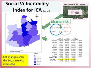
Figure 1: Social Vulnerability Index Industrial Complex Area(SVI-ICA) Ref. 1)

The district level of the social vulnerability index can be figured out by statistical data. However, sub-district and village level data should be difficult to collect such data. Based on the fact, the capacity assessment is firstly conducted to the target four sub-districts as indicated in Figure 2. The capacity assessment method was based on the FDPI project experience.

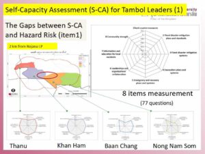
Figure 2: Four Sub-District Capacity Assessment 

The findings say the western side and eastern side have a big gap as you can see in Figure 2.

Figure 3 indicates the education and training part is much different among the four target sub-district. This means we can monitor and evaluate their progress after we provide education, training, system, or so on there.

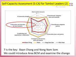
Figure 3: Capacity Assessment Analyses

The detailed examination will be explained later.

*Exposure, Susceptibility, and Capacity data list will be shown later. The theoretical frame is base on the PAR model. The below book can be referred.


At Risk: Natural Hazards, People’s Vulnerability and Disasters

**This is the baseline research for the SATREPS project.

Ref. 1) Tadashi Nakasu, Ruttiya Bula-or, Sutee Anatsuksomsti, Korrakot Positlimpakul (2019)Social Vulnerability Changes and Sustainable Development in the Flooded Industrial Complex Area The 2nd multidisciplinary International Conference on Humanities (ICH 2019) “Innovation and Transformation in Humanities for a Sustainable Tomorrow.” 30-31 October 2019, School of Humanities, Universiti Sains Malaysia, Penang, Malaysia

Day_158: Disaster Warning (2)

I will update a column of the NIED e-mail magazine which I wrote a long time ago because the content is not faded with time. (I will do this step by step in Japanese and English) I will also add comments to update the situation.

Sorry, now I am revising this post because of the difficulties of the translation. This post will be revised again. Thank you.

Published June 4, 2010
NIED-DIL e-mail magazine: Disaster Warning (2)

■ Disaster Warning (2) ■

Following the tornado that hit Saroma in Hokkaido in November 2006, I was given the opportunity to visit Oklahoma in the United States in February 2007 for a survey on tornado disaster response, especially tornado disaster alerts. In particular, I visited mainly the NWC (National Weather Center) built inside the University of Oklahoma. At there, Professor Emeritus Yoshikazu Sasaki helped us. He is very famous for being a model of the Hollywood movie “Twister.” I learned that U of Oklahoma, especially a climatological course rapidly became competitive in the U.S. after the movie was released. In the movie “Twister,” there was a scene where cows were flying in the air, at NWC, there was a coffee shop called Flying Cow.

The most impressive thing about the visit was the recognition that the NWC needed a wide range of cooperation on tornado response and put emphasis on community awareness. Regarding multi-disciplinary collaboration, the reason behind this is that even if we increase the accuracy and speed from tornado prediction to warning by science and technology, it will be human beings that will respond to it. Also, there is an organization called the Warning Decision Training Branch (WDTB) <Warning Judgment Training Center> inside the university. The existence is based on the fact that the decision of warning (Warning Decision) is not only radar data, but also specialized in model guidance and mesoscale analysis in combination with the human mind. People, the Emergency Manager, make decisions based on a variety of factors, including technical knowledge and reports from spotters (registered volunteers who inform the situation on the spot). The local factors and political conditions are also overlapped. The knowledge of meteorology expertise alone could not attain the purpose.

As for local enlightenment activities, as a contribution to the community, create and publicize many brochures, open a center, for example, tie-up with McDonald’s in a program called McLeady and give educational advertisements was doing. In this way, the NWC recognizes that disaster alerts are based on various factors such as understanding of human behavior, bonding with society, and political situations, and it is common sense that meteorology alone cannot respond. It was impressive that it was done.

Issued June 4, 2010-Issue 5

https://disasterresearchnotes.site/archives/2553

Day_156: Matsushiro Earthquake Center_NIED-DIL e-mail magazine

I will update a column of the NIED e-mail magazine that I wrote long ago because its content has not faded with time. (I will do this step by step in Japanese and English.) I will also add comments to update the situation.

Published April 5, 2010
NIED-DIL e-mail magazine: Matsushiro Earthquake Center

■ Matsushiro Earthquake Center ■

There is an organization called Matsushiro Earthquake Center in Matsushiro, Nagano Prefecture, Japan. The Center was established in February 1967 at the Japan Meteorological Agency in Matsushiro Town, Nagano Prefecture (now Nagano City), based on the Matsushiro Seismological Observatory, which was established in 1947. The background of this establishment is that between August 3, 1965, and April 17, 1966, insensitive earthquakes with seismic intensities 5 and 4 were observed three times each and a total of 6,780 earthquakes were detected in the Matsushiro town area. This severe earthquake activity has become a major social problem.

It is famous that Mayor Nakamura at that time said that he wanted to learn and research more than things and money, and that was the starting point of the Center. The Center is also well known as the location where the imperial general headquarters was planned to be built at the end of the Second World War. Besides, the experience gained from the observation of the earthquake has dramatically influenced the progress of earthquake prediction and disaster countermeasures today.

The author is organizing the records of the discourse at the time with the cooperation of the Japan Meteorological Agency’s Earthquake Observatory (Matsushiro Seismological Observatory) as the Disaster Information Office. I am surprised at the fascinating records. The fact that Matsushiro city was working to build a disaster-resilient town in the wake of an earthquake throughout the city is well communicated. For example, there was not only research on the earthquake itself but also research on the health status of students, including psychological aspects from nearby schools caused by a swarm. This was due to the cooperation of Matsushiro health centers and hospitals. It does not stop there. Members were active in the front lines of various fields at the time, such as landslide surveys caused by earthquakes and the impact on water supply facilities during earthquakes, reports from various perspectives.

I am sorry that the format, etc. is still insufficient, but I am starting to release these records on the HP in hopes that you can see it in a provisional form. Please see if you have time.

URL: http://dil.bosai.go.jp/library/matsushiro/MRecord.html

Now you can not access it, but you can ask NIED DIL for information.

Published on April 5, 2010

Matsushiro Seismological Observatory
https://www.data.jma.go.jp/svd/eqev/data/matsushiro/en/index.html

Day_155: Recoveries from Disasters

I will update a column of the NIED e-mail magazine which I wrote a long time ago because the content is not faded with time. (I will do this step by step in Japanese and English.) I will also add comments to update the situation.

Published March 5, 2010
NIED-DIL e-mail magazine: Recoveries from Disasters

■ Disaster Recoveries ■
Global attention is being focused on how recovery will take place after the Haiti earthquake. I have studied a lot about disaster recovery. Still, as a valid theory of thinking, a researcher named Haas says, “A rapidly growing city will recover quickly after the disaster but will remain unchanged, and stagnant or downhill cities will recover very slowly after the disaster or will quickly decline “(1977). When considering what kind of area or growing city it is in this case, the population before the disaster could be examined as an indicator. I’ve researched a lot and predict that no matter how massive the distraction, an area with a growing population may be easier to recover. For example, in the city of Nagoya, due to the Typhoon Ise Bay disaster, the scale of economic and social damages was plentiful, and the amount of aid was small, but it was said that it was revived in less than a year. In comparison, the scale of economic and social disasters in New Orleans due to the Hurricane Katrina disaster was not so large, relative to statistics, but the amount of aid was enormous. Nevertheless, it may be useful to say that five years have passed and that recovery has not yet been good. New Orleans was even expressed as a surviving city, even before the disaster. Regarding the recovery of the stricken area of ​​the Indian Ocean tsunami, it is not clear here, but there were many similar trends.
Let’s return to the example of Haiti. Examination of the population growth rate in Haiti (Port-au-Prince) showed that it was overgrowing until the disaster occurred. Haiti’s revival should be relatively quick, given the population index alone. However, it is also possible that Haiti has an entirely different social situation that cannot be applied to the above example. You may have to think that Haiti’s revival will be heavily influenced by the very elusive variables of political steering and social conditions. There is an article in the magazine “ Economist ” that fears that similar problems may occur in Haiti, such as the problem of contributions and aid in the Indian Ocean cases where oversupply was unevenly distributed and the damage was widened.
What do you think of Haiti’s recovery?

P.S.
The data below indicates a lot about the theory.

Haiti Population Data
https://www.worldometers.info/world-population/haiti-population/

Port-au-Prince Population Data
https://populationstat.com/haiti/port-au-prince

Day_154 : (In Japanese) 災害からの復興

かなり前に書いたメールマガジンのコラムですが、内容は、色あせていないので、復習を兼ねて、これから数回にわたり掲載致します。(同様に英語版も順番に掲載していきます。)

2010年3月5日発行
再掲NIED-DILメールマガジン:2回】災害からの復興
□■災害からの復興■□
ハイチの大地震で復興はどのようになるのか、世界の注目は集まっています。
これまで復興についていろいろと調べましたが、考える指針の有効な理論とし
てハースという研究者らの「急速に成長しつつある都市は、被災後急速に復興
するであろうが、変化せず停滞し、あるいは下り坂にある都市は、被災後きわ
めて緩慢に復旧するか、あるいは急激に衰えていくであろう」(1977)があり
ます。この場合の成長する都市とはどういう地域かを考えた際、災害前の人口
の増加が結構指標として使えるのではないかと考えられます。実際、いろいろ
と調べたのですが、災害がどれだけ大きなものであっても、人口が増加傾向に
あった地域は、復興しやすいのではないかという予測です。例えば、伊勢湾台
風災害による名古屋市では、経済・社会的な災害の規模が大きく援助量が少な
かったのですが、一年とたたないぐらいあっという間に復興したといえる状況
になりました。比べて、ハリケーン・カトリーナ災害によるニューオリンズで
は、経済・社会的な災害規模としては、実はそれほど大きくなかったのですが、
援助量は膨大でした。にもかかわらず5年たとうとしているのに、復興はまだ
ままならないといってよい状態かもしれません。ニューオリンズは災害前から
人口の減少が著しく、サバイバルな都市とさえ言われていました。インド洋大
津波の被災地の復興についても、ここでははっきりといえませんが、同様な傾
向が多く見うけられます。
さて、ハイチの例に戻って考えてみます。ハイチ(ポルトープランス)の人
口増加率を調べてみると、災害前まで急速に増えていたことがわかりました。
人口という指標だけで考えるとハイチの復興は比較的早く成し遂げられるはず
ということになります。しかしながらハイチには上記の例では当てはめて考え
ることができない全く異なる社会状況が存在するとも考えられます。そのため
ハイチの復興は、政治の舵取りや社会状況という非常にわかり難い変数に大き
く左右されると考えなければならないのかもしれません。雑誌「エコノミス
ト」には、インド洋で起こった義援金や援助の問題、偏ったところに過剰に供
給され被害が拡大した事例など、と同様な問題がハイチでも起こるのではない
かと危惧する記事がありました。
皆さんはハイチの復興をどう考えますか。

2010年3月5日発行

Day_152 : (In Japanese) 災害による報告死者数

かなり前に書いたメールマガジンのコラムですが、内容は、色あせていないので、復習を兼ねて、これから数回にわたり掲載致します。(同様に英語版も順番に掲載していきます。)

2010年2月4日発行
再掲NIED-DILメールマガジン:1回】災害による報告死者数
■災害による報告死者数■

1月12日ハイチで大きな地震がありました。その影響は、現在でも大きな社会問題ともなっていますが、初期の段階で大統領が20万人の犠牲者が出ていると宣言しました。

2005年8月末のハリケーン・カトリーナ災害のときは、最初1万人との報道がなされましたが、最終的に1千3百人ぐらいになりました。死者が少ないのに越したことはありませんが、日本と比べてお国柄がこのようなところにもでるのかと感じます。

日本の場合で典型的な事例は、阪神・淡路大震災の時です。当時筆者は京都に住んでおり、京都市内で働いておりましたが、大きなゆれのあと、朝7時ごろは、死者の数がまだ数人だったとTVなどで報道されていたのを覚えています。それが時間が経つにつれて、数百人、数千人と時間が経つごとに増えていきました。

アメリカは、トップダウンで戦略的、日本は、ボトムアップで正確さ重視、そんな感じがします。2004年のインド洋津波では、周辺諸国の報告死者数が上下していましたが、この点をとっただけでも、災害がその国の経済や社会状況を浮き彫りにする一端が見えてきます。

ハイチに関しては時を追うごとに報告死者数が増えておりその状況が心配されます。初期の段階の大統領の宣言どおりの数字にならないことを祈ります。

2010年2月4日発行

P.S.

例えば下記のワールドビジョンのHPでは、現在の推定死者を、250,000人としています。つまり、最初の報告は最終的には、ある意味的を得ていたことになってしまいました。

https://www.worldvision.org/disaster-relief-news-stories/2010-haiti-earthquake-facts

Day_151 : Disaster Information 5

I had a query on historical earthquake information in Japan. Therefore, I update the new useful disaster information especially historical data in Japan.

The following is the archive of disasters (can select disaster type, year, and area) all over Japan but only in Japanese.
The archive was created to collect all local government data in Japan.
The best book to know the historical earthquake disaster record is the following book. This is also only in Japanese.


The followings are the same as the disaster information 4.

Flood list: an excellent source of flood disasters
floodlist.com/tag/thailand
AHA center- adinet: disasters in ASEAN countries can be browsed and also checked in detail.

DRH-Asia: cases on local knowledge and their applications related to the technologies in Asian countries can be found.
http://drh.bosai.go.jp/
The post of the disaster information 3 is the followings:
https://disasterresearchnotes.site/archives/3171
——

Introduced you to the following disaster information.
1) General info. 2) Database 3) Update info

1) General info is the first website to check.
1. UNISDR

unisdr

2) Database is the base to analyze the target disasters.
1. EM-DAT

emdat

2. Desinventar

disinventar

The disinventar is very accurate and detailed, however, the listed
countries are limited.

3) Update info. Is the website, we can check on a daily basis.
These are also useful to overview of the recent disasters.
1. ReliefWeb

reliefweb

2. ADRC

adrc

3. ROSE

ROSE

4. GDACS

GDACS

Concerning, data on demographic, socioeconomic, and others, we should
clarify the levels from national to local.

County Level
1. UN data

undata

2. World Bank open data

world bank data

3. CIA world factbook

world fact book

Provincial (States) Level
1. Government Office (National Statistics Office,etc.)

Community Level
1. Local Government Office
When we investigate the disasters, we first go to the ADRC (if the country is Asia) and Relief Web to see some significant numbers such as the death toll and affected numbers. Then, check the disaster history of the target areas by EM-DAT and Desinventar (if the country is listed). We also overview the county’s background by CIA world fact book and check some socio-economic data by UN or World bank open data. In addition, the local government or community data of the target area are significant to be accessed. These are the primary action to grasp the whole picture of the disaster.

Day_150: Sea Level, Rainfall, and Temperature Changes in Thailand

Bangkok is very hot this year.  Just share the results which I did on sea level, rainfall and temperature changes in Thailand from a long-range perspective.

The tide gauge at KO LAK in PrachuapKhri Khan indicates the annual mean sea level is rising. Especially, the sea level is rapidly rising after 2000.

Temperature

Warmer than before and the gap between warmer and colder (STD) is smaller.

Rainfall

Almost all the same average and std, but we can see the pattern (the peak) has changed.

The rainfall peak became earlier.

Will explain in detail later………..

Day_149: Flood Disaster Preparedness Indices (FDPI)

ICHARM (International Centre for Water Hazard and Risk Management) allowed me to engage in the project on the development of Flood Disaster Preparedness Indices (FDPI). This project is also linked to one of the projects of the Typhoon Committee (World Meteorological Organization/United Nations ESCAP).

You can see the outline of the project on the following website:.

http://www.apan-gan.net/adaptation-technologies/database/flood-disaster-preparedness-indices-fdpi

The established site is the self-evaluation system for local disaster managers around the world, especially in developing countries. Therefore, we have prepared the multi-language (16 languages) versions. You can evaluate your community’s preparedness ability by yourself, and experience can also be shared depending on your situation.  You can easily see your results on the website. The results are automatically sent to the administrator to check on the situation. If the administrator understands the severity, he or she can communicate with the international aid agencies.

http://www.fdpi.jp/fdpi/

To be continued…