Disaster Information」カテゴリーアーカイブ

Day_187: Disaster Definitions


Day_23 : The Definitions


Disasters are indeed categorized based on their origin and the factors that contribute to their occurrence. This categorization into natural, technological, and human-made disasters is critical for understanding the varying dynamics of disaster risk, management, and mitigation strategies. Here’s a brief overview of each category, along with references that provide in-depth insights:

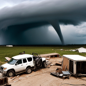
1. Natural disasters: These include earthquakes, hurricanes, floods, wildfires, and volcanic eruptions as examples of natural processes and phenomena. Even though human activity can exacerbate their effects, natural disasters are frequently beyond human control.

Reference: Cutter, S. L. (2005). The Geography of Social Vulnerability: Race, Class, and Catastrophe. Social Science Quarterly, 84(2), 242-261. This work explores the social dimensions of vulnerability to natural disasters, highlighting the intersection of social factors with natural phenomena.

2. Technological Disasters: Also known as anthropogenic or man-made disasters, these occur as a result of technological or industrial accidents, infrastructure failures, or specific human activities that lead to catastrophic events. Examples include chemical spills, nuclear accidents, and industrial explosions.

Reference: Perrow, C. (1984). Normal Accidents: Living with High-Risk Technologies. Princeton University Press. Perrow analyzes the inherent risks of complex technological systems and the inevitability of failures that lead to disasters.

3. Human-Made Disasters: This category includes events that are a direct result of human actions but are not necessarily related to technological failures. These can include acts of terrorism, armed conflicts, and widespread violence. Human-made disasters are characterized by their intentional nature and the purposeful infliction of harm on communities or the environment.

Reference: Wisner, B., Blaikie, P., Cannon, T., & Davis, I. (2004). *At Risk: Natural Hazards, People’s Vulnerability, and Disasters*. Routledge. Although primarily focused on natural hazards, this book provides a comprehensive framework for understanding vulnerability and resilience in the context of various disaster types, including human-made events.

Each of these categories underscores the need for tailored approaches to disaster risk reduction, preparedness, response, and recovery. Understanding the specific characteristics, causes, and impacts of each type of disaster is crucial for developing effective management and mitigation strategies.

Day_174: (Revised) Unraveling the Twister Mysteries: A Captivating Dive into the Science of Tornadoes


Tornadoes rank among nature’s most formidable forces, with potential wind speeds exceeding 300 miles per hour and wreaking havoc on homes, businesses, and communities. This piece delves into the atmospheric dynamics leading to tornado formation and the ongoing research enhancing our comprehension of these violent weather phenomena.

Formation and Conditions

Tornado genesis stems from specific atmospheric conditions—namely, the collision of warm, moist air from the Gulf of Mexico with cold, dry air from Canada, fostering unstable conditions ripe for severe thunderstorms. Within these storms, varying wind speeds and directions at different altitudes (wind shear) play a pivotal role, promoting the air column’s rotation and eventual condensation into a tornado.

Structure and Measurement

A tornado’s anatomy features a rotating air column, or vortex, visible as a funnel-shaped cloud laden with debris. Their intensity is gauged using the Enhanced Fujita Scale, ranging from EF0 (weakest) to EF5 (strongest), based on inflicted damage and wind speed within the vortex.

Tornado Watches vs. Warnings

Understanding the distinction is crucial for safety: a *tornado watch* signals potential tornado conditions, whereas a *tornado warning* indicates an imminent or occurring tornado, urging immediate shelter.

Safety Protocols

Preparedness involves staying informed, having a shelter plan, and knowing protective actions if caught outdoors or driving during a tornado.

Historical Impact

Historic tornadoes, such as the 1925 Tri-State Tornado and the 2011 Joplin Tornado, underscore the critical need for preparedness and awareness due to their devastating impact.

Research and Climate Change

Tornado chasing and research have enriched our understanding of tornado dynamics. Meanwhile, the potential influence of climate change on tornado patterns—including frequency, intensity, and geographic shifts—warrants ongoing study to adapt preparedness and response strategies effectively.

The intricate science behind tornadoes reveals the significance of continued research and preparedness in mitigating the impact of these awe-inspiring yet destructive storms. As our knowledge evolves, so too does our capacity to predict, prepare for, and protect against the formidable power of tornadoes.


Day_168 : Past Interview Records – PTWC (Pacific Tsunami Warning Center) in Hawaii (1)

Continue to the past New Orleans Interview Records, I would like to open the memo about the interview to PTWC. It was a great time and I learned a lot from the interviews.  So I would like to share the fact to let you know their works to tackle the tsunami disasters in the world.

PTWC is the core center for the tsunami warning well known to the world.

2008.2.26 (Tue.) at 1000 am
15 staff, director, deputy director
Information Technician, including nine scientists
16-hour shift on 8-4-4, homes are next to the center

The records from the interview survey are shown below.

■ Evacuation
There is no international standard in terminology. Terminology varies by country/region. The words sometimes make me confused. Also, in the past, it was two either evacuation nor no evacuation.

■ Warning Error
It is challenging to give a warning. There are errors in the original earthquake and the tide data. There is an error in the gauge also.
To judge them collect is too hard. So, it can be said that 99.99% is an error.

In Hawaii, only a quarter of evacuation was actually damaged in the past. It is not unusual that although there were evacuations, there were no damages at all.

■ Past data and warning judgment
Only use a few. Because how to put out the past data, equipment, etc.are hard to do. Which way is the numerical model used to determine if the earthquake becomes a tsunami is complicated. There are more things to do.

■ Relationship with other countries
The countries that are most focused on warning about tsunami in the Pacific are Japan, America, Australia, Chile, Canada, and Russia. Also, it is not possible to evaluate the inspection records of other countries. This should be noted.

■ At the time of the 2004 tsunami
Most of the records before the Indian Ocean Tsunami were reported hourly, so judge the event was tough. Every 15 minutes, now every 6 minutes is normal and very good.

■ Conditions for cancellation
Make a comprehensive decision. The problem of reflections adds to the complexity. Not only direct waves but also an indirect wave should be considered.

Day_162: Disaster Links Library

As mentioned below, the Disaster Links Library has been created. The first draft is attached to this menu as “Disaster Links Library”. There are still many challenges ahead, however, the page will be completed step by step with adding more info.

If you have some excellent links, please let me know.

https://disasterresearchnotes.site/archives/3793

sponsored link

Day_158: Disaster Warning (2)

I will update a column of the NIED e-mail magazine which I wrote a long time ago because the content is not faded with time. (I will do this step by step in Japanese and English) I will also add comments to update the situation.

Sorry, now I am revising this post because of the difficulties of the translation. This post will be revised again. Thank you.

Published June 4, 2010
NIED-DIL e-mail magazine: Disaster Warning (2)

■ Disaster Warning (2) ■

Following the tornado that hit Saroma in Hokkaido in November 2006, I was given the opportunity to visit Oklahoma in the United States in February 2007 for a survey on tornado disaster response, especially tornado disaster alerts. In particular, I visited mainly the NWC (National Weather Center) built inside the University of Oklahoma. At there, Professor Emeritus Yoshikazu Sasaki helped us. He is very famous for being a model of the Hollywood movie “Twister.” I learned that U of Oklahoma, especially a climatological course rapidly became competitive in the U.S. after the movie was released. In the movie “Twister,” there was a scene where cows were flying in the air, at NWC, there was a coffee shop called Flying Cow.

The most impressive thing about the visit was the recognition that the NWC needed a wide range of cooperation on tornado response and put emphasis on community awareness. Regarding multi-disciplinary collaboration, the reason behind this is that even if we increase the accuracy and speed from tornado prediction to warning by science and technology, it will be human beings that will respond to it. Also, there is an organization called the Warning Decision Training Branch (WDTB) <Warning Judgment Training Center> inside the university. The existence is based on the fact that the decision of warning (Warning Decision) is not only radar data, but also specialized in model guidance and mesoscale analysis in combination with the human mind. People, the Emergency Manager, make decisions based on a variety of factors, including technical knowledge and reports from spotters (registered volunteers who inform the situation on the spot). The local factors and political conditions are also overlapped. The knowledge of meteorology expertise alone could not attain the purpose.

As for local enlightenment activities, as a contribution to the community, create and publicize many brochures, open a center, for example, tie-up with McDonald’s in a program called McLeady and give educational advertisements was doing. In this way, the NWC recognizes that disaster alerts are based on various factors such as understanding of human behavior, bonding with society, and political situations, and it is common sense that meteorology alone cannot respond. It was impressive that it was done.

Issued June 4, 2010-Issue 5

https://disasterresearchnotes.site/archives/2553

Day_157: Disaster Warning (1)

I will update a column of the NIED e-mail magazine which I wrote a long time ago because the content is not faded with time. (I will do this step by step in Japanese and English) I will also add comments to update the situation.

Sorry, now I am revising this post because of the difficulties of the translation. This post will be revised again. Thank you.

Published May 6, 2010
NIED-DIL e-mail magazine: Disaster Warning (1)

■ Disaster Warning (1) ■

In February 2008, a survey provided an opportunity to visit the Pacific Tsunami Warning Center (PTWC) in Hawaii. In a study, I interviewed the director of the PTWC, and the first thing that caught my attention was the role of the media. The director told me that a public tsunami evacuation alert required three hours before the event, which was too time-sensitive, but the media was an advantage to do this. However, for the government organization, there were various restrictions, such as warnings in an international framework. I remembered the Chilean Navy’s disaster response to the damage caused by the earthquake and tsunami in Chile in February this year.

Next, I was interested in science, technology, and data that are the basis of the alarm decision. I think that normal (flood etc.) warnings will be judged based on current and past data, but especially for tsunami warnings, there were errors in the data of the original earthquake and the tide gauge. To do judge, we should know the 99.99 percent could be the error. The fact that the past data is not very useful because the devices to figure out the data are changing day by day, making it difficult to rely on it.

From these facts, it was generally noticed that the disaster warning was based on the combination of the progress of science, technology and the competence of the person in charge. The actual warning also relies on the institution belonging to it. For example, it was also needed to add variables such as the recipient of the alert, the psychology of the local people, social situation, and various systems.

Issued May 6, 2010 No. 4

Ref.

https://disasterresearchnotes.site/archives/2592

Day_152 : (In Japanese) 災害による報告死者数

かなり前に書いたメールマガジンのコラムですが、内容は、色あせていないので、復習を兼ねて、これから数回にわたり掲載致します。(同様に英語版も順番に掲載していきます。)

2010年2月4日発行
再掲NIED-DILメールマガジン:1回】災害による報告死者数
■災害による報告死者数■

1月12日ハイチで大きな地震がありました。その影響は、現在でも大きな社会問題ともなっていますが、初期の段階で大統領が20万人の犠牲者が出ていると宣言しました。

2005年8月末のハリケーン・カトリーナ災害のときは、最初1万人との報道がなされましたが、最終的に1千3百人ぐらいになりました。死者が少ないのに越したことはありませんが、日本と比べてお国柄がこのようなところにもでるのかと感じます。

日本の場合で典型的な事例は、阪神・淡路大震災の時です。当時筆者は京都に住んでおり、京都市内で働いておりましたが、大きなゆれのあと、朝7時ごろは、死者の数がまだ数人だったとTVなどで報道されていたのを覚えています。それが時間が経つにつれて、数百人、数千人と時間が経つごとに増えていきました。

アメリカは、トップダウンで戦略的、日本は、ボトムアップで正確さ重視、そんな感じがします。2004年のインド洋津波では、周辺諸国の報告死者数が上下していましたが、この点をとっただけでも、災害がその国の経済や社会状況を浮き彫りにする一端が見えてきます。

ハイチに関しては時を追うごとに報告死者数が増えておりその状況が心配されます。初期の段階の大統領の宣言どおりの数字にならないことを祈ります。

2010年2月4日発行

P.S.

例えば下記のワールドビジョンのHPでは、現在の推定死者を、250,000人としています。つまり、最初の報告は最終的には、ある意味的を得ていたことになってしまいました。

https://www.worldvision.org/disaster-relief-news-stories/2010-haiti-earthquake-facts

Day_151 : Disaster Information 5

I had a query on historical earthquake information in Japan. Therefore, I update the new useful disaster information especially historical data in Japan.

The following is the archive of disasters (can select disaster type, year, and area) all over Japan but only in Japanese.
The archive was created to collect all local government data in Japan.
The best book to know the historical earthquake disaster record is the following book. This is also only in Japanese.


The followings are the same as the disaster information 4.

Flood list: an excellent source of flood disasters
floodlist.com/tag/thailand
AHA center- adinet: disasters in ASEAN countries can be browsed and also checked in detail.

DRH-Asia: cases on local knowledge and their applications related to the technologies in Asian countries can be found.
http://drh.bosai.go.jp/
The post of the disaster information 3 is the followings:
https://disasterresearchnotes.site/archives/3171
——

Introduced you to the following disaster information.
1) General info. 2) Database 3) Update info

1) General info is the first website to check.
1. UNISDR

unisdr

2) Database is the base to analyze the target disasters.
1. EM-DAT

emdat

2. Desinventar

disinventar

The disinventar is very accurate and detailed, however, the listed
countries are limited.

3) Update info. Is the website, we can check on a daily basis.
These are also useful to overview of the recent disasters.
1. ReliefWeb

reliefweb

2. ADRC

adrc

3. ROSE

ROSE

4. GDACS

GDACS

Concerning, data on demographic, socioeconomic, and others, we should
clarify the levels from national to local.

County Level
1. UN data

undata

2. World Bank open data

world bank data

3. CIA world factbook

world fact book

Provincial (States) Level
1. Government Office (National Statistics Office,etc.)

Community Level
1. Local Government Office
When we investigate the disasters, we first go to the ADRC (if the country is Asia) and Relief Web to see some significant numbers such as the death toll and affected numbers. Then, check the disaster history of the target areas by EM-DAT and Desinventar (if the country is listed). We also overview the county’s background by CIA world fact book and check some socio-economic data by UN or World bank open data. In addition, the local government or community data of the target area are significant to be accessed. These are the primary action to grasp the whole picture of the disaster.

Day_149: Flood Disaster Preparedness Indices (FDPI)

ICHARM (International Centre for Water Hazard and Risk Management) allowed me to engage in the project on the development of Flood Disaster Preparedness Indices (FDPI). This project is also linked to one of the projects of the Typhoon Committee (World Meteorological Organization/United Nations ESCAP).

You can see the outline of the project on the following website:.

http://www.apan-gan.net/adaptation-technologies/database/flood-disaster-preparedness-indices-fdpi

The established site is the self-evaluation system for local disaster managers around the world, especially in developing countries. Therefore, we have prepared the multi-language (16 languages) versions. You can evaluate your community’s preparedness ability by yourself, and experience can also be shared depending on your situation.  You can easily see your results on the website. The results are automatically sent to the administrator to check on the situation. If the administrator understands the severity, he or she can communicate with the international aid agencies.

http://www.fdpi.jp/fdpi/

To be continued…

Day_148: The World Largest Disaster Links

Below is the disaster links site, which was created a long time ago. I will renew this site step-by-step. In addition, some are still only in Japanese, and original disaster-related pictures are omitted, so I will also consider these.

http://disasters.weblike.jp/linklibrary.html

The below disaster-related world organization’s link site is the one that was built when I was working at NIED DIL and is still working as one of the products there. I am very happy to know that, but I would also like to renew this to contribute to the institute with my gratitude in the near future, I hope.

https://dil.bosai.go.jp/link/world/english/index.html