
Various categories of natural disasters exist, each possessing distinct attributes and consequences. Earthquakes, tsunamis, volcanic eruptions, floods, hurricanes, and tornadoes are often occurring natural disasters. These calamities can occur in any part of the globe, although specific areas are more susceptible to particular types of disasters owing to their geographical positioning and environmental circumstances.
As an illustration, the Pacific Ring of Fire is widely known for its elevated seismic activity, rendering it susceptible to earthquakes and volcanic eruptions. Conversely, the Atlantic and Gulf coasts of the United States frequently experience hurricanes as a result of their positioning in the temperate seas of the Atlantic Ocean.

Day_189: Understanding Heat Waves and Their Big Impact
When it gets boiling for several days, it’s often because of heat waves. These are a big deal and not just a minor inconvenience because they result from numerous intricate factors. Let’s explore what causes heat waves, how they affect us and the environment, and what we can do about them. As climate change makes heat waves more intense, it’s essential to learn about them and consider how to adapt.
What Causes Heat Waves?
Heat waves happen when the weather stays scorching for a long time. This is usually because high-pressure systems trap warm air in one place. No clouds mean lots of sunshine, making it even hotter. Other things like jet streams, hotter cities than surrounding areas, dry soil, and lack of plants can worsen heat waves. Significant weather patterns over the ocean, like El Niño, can also change how often and how severe heat waves are. Understanding all this helps us prepare for and try to lessen the harmful effects of heat waves.
How Do Heat Waves Affect Us and Nature?
Heat waves can cause many problems. They can lead to more wildfires, harm wildlife, and reduce the amount of food farmers can grow. They also use up a lot of water. People’s health can suffer, too, especially from heat-related illnesses. Heat waves can make some health conditions worse, lower air quality, and increase diseases spread by mosquitoes and ticks.
Dealing with Heat Waves
To deal with heat waves, we can plant more trees in cities, build buildings that don’t get as hot, and ensure everyone knows how to stay cool. With more heat waves expected because of climate change, building stronger buildings and improving weather warning systems is essential to keep everyone safe.
Getting Ready for More Heat Waves
As heat waves become more common, we all need to prepare. This means knowing how to keep cool, strengthening our communities against heat, and supporting laws that help deal with heat waves. By working together, we can be better prepared for hot weather and ensure everyone stays safe.
Day_177: Earthquake Preparedness and Response: Lessons from Turkey’s Seismic History

Image Source: FreeImages
The recent severe earthquake in Turkey has caused significant suffering throughout the country. This catastrophe serves as a stark reminder that natural disasters are far from ordinary occurrences. It is essential for us to learn and grow from each experience, not only within the affected country but also on a global scale. The article discusses Turkey’s earthquake history and how the nation has implemented lessons learned from past events. This analysis highlights the importance of continuous learning in order to better prepare for and respond to such disasters.
Introduction to Turkey’s seismic history
Turkey, a country bordering Europe and Asia, has suffered earthquakes before. It is incredibly vulnerable to these disasters because of its location on the seismically active Anatolian Plate. Turkey has historically seen some of the most damaging earthquakes in the world. Understanding the nation’s seismic history and drawing from its experiences can teach other countries valuable lessons on preparing for and responding to earthquakes.
A better understanding of how to predict, prepare for, and respond to these catastrophes has been made possible by the terrible impacts of earthquakes on Turkey. The country’s response plans have improved, using new engineering innovations and construction techniques to reduce casualties and property damage. In this post, we will examine Turkey’s seismic past, the significance of Adobe architecture there, and the lessons we can draw from Turkey to improve our readiness for and response to earthquakes.
Understanding earthquakes: Causes and types
Energy is released during the shifting and grinding of tectonic plates, which results in earthquakes. Large plates that make up the Earth’s crust are constantly moving and can collide, divide, or slide past one another, which can cause the ground to shake. Tectonic, volcanic, and induced earthquakes are the three main categories of earthquakes. The movement of the Earth’s plates causes the most frequent earthquakes, known as tectonic earthquakes. While induced earthquakes are brought on by human activity, like the mining of natural resources or the construction of huge reservoirs, volcanic earthquakes are brought on by the flow of magma beneath the Earth’s surface.
The Anatolian Plate, which is being compressed between the Eurasian and Arabian Plates, is Turkey’s leading cause of seismic activity. This tectonic activity has created numerous fault lines nationwide, making it vulnerable to earthquakes. For instance, the North Anatolian Fault, a strike-slip fault with a length of more than 1,000 kilometers, has caused multiple disastrous earthquakes in Turkey’s history.
The Significance of Adobe Structures in Turkey
Turkish architecture has long used adobe constructions built of soil mixed with straw or other organic materials. These constructions, frequently seen in rural locations, have served as fortifications, houses, and public facilities. The key benefits of Adobe structures are their affordability, simplicity, and great thermal qualities, which assist in maintaining a comfortable interior temperature all year round.
However, regarding seismic activity, Adobe constructions also suffer from serious drawbacks. These structures are particularly prone to collapsing during earthquakes because of their weight and low tensile strength. Throughout Turkey’s history, many large earthquakes have painfully illustrated this susceptibility, resulting in the death of countless people and extensive destruction.
Due to this, Turkey’s rising focus is on enhancing the seismic performance of Adobe structures. Researchers and engineers have been working on developing innovative techniques and materials to increase the earthquake resistance of these traditional structures and preserve their cultural relevance while ensuring the safety of their occupants’ safety.
Major earthquakes in Turkey’s history and their impact
Throughout its history, Turkey has been the site of many large earthquakes, some of which have had devastating effects. The Erzincan earthquake in 1939, the Izmit earthquake in 1999, and the Van earthquake in 2011 are three of the most famous. These seismic occurrences resulted in extensive property damage and fatalities and changed the nation’s strategy for earthquake preparedness and response.
Approximately 33,000 people perished in the 7.9-magnitude earthquake that struck Erzincan in 1939, and many more were injured or left homeless. This catastrophe made it clear that better seismic monitoring, prediction, and earthquake-resistant building techniques are required.
With nearly 17,000 fatalities and more than 50,000 injuries, the 1999 Izmit earthquake, which registered a 7.6 on the Richter scale, was among the deadliest and most catastrophic in modern Turkish history. The significant destruction brought on by this incident highlights the significance of strengthening earthquake preparedness and response strategies.
The most recent earthquake, the 7.1 magnitude Van earthquake in 2011, significantly damaged the Adobe structures in the area, killing over 600 people and displacing thousands more. This catastrophe also emphasized the necessity for improvements in construction methods and supplies for Adobe to improve its seismic performance.
Earthquake preparedness: What we can learn from Turkey
Turkey’s earthquake experiences have taught the country important lessons about preparedness. Adopting strict building regulations that account for seismic risks is crucial to earthquake preparedness. Turkey has made tremendous progress in this area; as of present, the country’s building codes demand that buildings be built resistant to earthquakes.
The creation and upkeep of early warning systems is vital to earthquake preparedness. Turkey has made significant investments in seismic monitoring and early warning systems, which can give locals crucial information in the minutes before an earthquake. By giving people enough time to take refuge or flee dangerous structures, this early warning can help save lives and reduce damage.
Finally, vital elements of earthquake preparedness are public awareness and education. Turkey has put a lot of effort into informing its inhabitants about the dangers of earthquakes and the essential safety measures to follow in the case of one. These are examples of regular earthquake exercises in schools, public awareness campaigns, and the distribution of earthquake safety informational materials.
Building earthquake-resistant Adobe structures
Several important regions have been the focus of efforts to increase the seismic performance of Adobe structures in Turkey. To strengthen their tensile strength and earthquake resistance, old Adobe buildings have been reinforced with contemporary materials like steel or concrete. Concrete columns, reinforced Adobe bricks, or the installation of steel reinforcement bars can all be used to achieve this.
Another strategy is the creation of fresh construction methods that more evenly disperse seismic pressures across the building. Using adaptable hardwood frameworks, using seismic-resistant design concepts, or using cutting-edge materials like fiber-reinforced Adobe are a few examples of how to do this.
Turkish scientists and engineers are also looking into the possibility of enhancing the earthquake resistance of Adobe constructions by employing locally derived ecological materials. This includes using natural fibers to increase the tensile strength of Adobe bricks, such as hemp or straw.
Effective earthquake response strategies in Turkey
The tactics used in Turkey to respond to earthquakes have also been informed. The quick deployment of rescue teams to find and aid stranded or injured people is crucial to an effective earthquake response. Specialized search and rescue squads in Turkey have received funding for training and equipment, and they are frequently among the first to arrive in earthquake-affected areas.
The provision of temporary housing and other services to displaced populations is a vital component of the earthquake response. Turkey has established an effective system for disaster response, including pre-stocked emergency supplies and temporary housing that can be quickly distributed to impacted communities after an earthquake.
Finally, effective earthquake response requires coordinated efforts from national and local governments, non-governmental organizations, and international partners. In the wake of significant earthquakes, Turkey has shown the usefulness of such cooperation, with international aid frequently playing an essential part in the nation’s rebuilding efforts.
Public awareness and education on earthquake preparedness
As informed populations are more prepared to respond to devastating disasters, public awareness, and education are essential to earthquake preparedness. The dissemination of educational materials, public awareness campaigns, and integration of earthquake safety education into school curricula are just a few of Turkey’s steps to increase general understanding regarding earthquake preparedness and response.
The “Safe School Program” is one significant part of Turkey’s public awareness campaigns. Schools are assessed for their capacity to withstand earthquakes as part of this program, and any necessary adjustments are made to protect the safety of students and staff in the event of an earthquake. Regular earthquake exercises are another curriculum feature that aids in preparing children and teachers for seismic occurrences.
International Collaboration for earthquake preparedness and Response
Because earthquakes are worldwide in scope, successful earthquake preparedness and response depend on international cooperation. The establishment of uniform building norms, the exchange of seismic monitoring data, and the provision of aid for disaster response are just a few of the ways that Turkey has actively participated in worldwide initiatives to increase earthquake resilience.
The World Housing Encyclopedia, which attempts to offer details on the seismic performance of structures worldwide, is a key endeavor in this area. Turkey has contributed to this effort by offering important information on the seismic performance of its conventional Adobe structures.
Building a resilient future for Turkey and Beyond
Turkey’s earthquake experiences taught us essential lessons about preparedness and response. Turkey has made tremendous progress in lessening the effects of earthquakes on its population by enacting strict construction rules, creating early warning systems, and improving public awareness about earthquake safety.
Researchers and engineers are looking for new methods and materials to increase the seismic performance of conventional Adobe structures in Turkey, which is a continuous effort. These initiatives could significantly impact earthquake-prone areas worldwide where traditional building materials and techniques are still widely used.
Finally, increasing earthquake resilience globally requires global cooperation and knowledge sharing. By cooperating, nations can benefit from one another’s experiences and create plans to lessen the effects of earthquakes on their populations.
To sum up, Turkey’s seismic past warns about the significance of earthquake preparedness and reaction. We can create a more resilient future for ourselves and future generations by implementing the lessons discovered from Turkey’s experiences in our communities.
Day_176: Empowering Pacific Island Countries: Innovative Strategies for a Disaster-Resilient Future

Let’s learn about disaster risk reduction in Pacific Island countries.
For Pacific Island countries (PICs), which are vulnerable to climate change and natural disasters, including tropical cyclones, earthquakes, tsunamis, and volcanic eruptions, disaster risk reduction (DRR) is a crucial part of sustainable development. These occurrences could severely impact the environment, the local economy, and the local communities. It is now more crucial than ever for PICs to concentrate on improving their capacity for disaster risk reduction and resilience.
The concept and practice of disaster risk reduction (DRR) are described by the United Nations Office for Disaster Risk Reduction (UNDRR) as “the concept and practice of reducing disaster risks through systematic efforts to analyze and manage the causal factors of disasters, including through reduced exposure to hazards, lessened vulnerability of people and property, wise management of land and the environment, and improved preparedness for adverse events.” This entails comprehending the particular difficulties that PICs confront in the Pacific region, figuring out the best ways to deal with these difficulties, and cooperating to secure a more resilient future for everyone.
This article discusses how crucial disaster risk reduction is for the Pacific region, looks at essential tactics for improving DRR, looks at examples of effective programs, and thinks about how local knowledge and global cooperation may help create a resilient culture. Pacific Island countries may lessen their susceptibility, promote sustainable development, and be better prepared for future calamities by implementing these measures.
Pacific Island countries face distinct challenges that are unique to their region.
Pacific Island countries have many specific difficulties when it comes to reducing the risk of disasters. First and foremost, they are particularly vulnerable to disasters because of their location. PICs are vulnerable to volcanic eruptions, earthquakes, and tsunamis because of their location along the Pacific Ring of Fire. The area is also frequently affected by tropical cyclones, which can result in extensive harm and destruction.
PICs’ low resources, disaster preparedness, and response capacity present another critical obstacle. Many of these nations’ inhabitants, infrastructure, and financial resources are modest. As a result, they frequently struggle to create and keep up with the required structures and methods for efficient disaster risk reduction.
Additionally, the effects of climate change are increasing already-existing threats and developing new ones for Pacific Island nations. Natural disasters are becoming more frequent and severe in the area due to rising sea levels, rising temperatures, and altering weather patterns. This makes improving disaster risk reduction in the Pacific much more complex and urgent.
Reducing the risk of disasters in the Pacific region is paramount.
It is impossible to exaggerate the significance of disaster risk reduction in the region of the Pacific. Natural disasters can wreak havoc and create great destruction, affecting the environment, the economy, and communities that persist for years. The Pacific island countries can lessen these effects, save lives, and safeguard their development achievements by investing in disaster risk reduction.
The Pacific region’s Sustainable Development Goals (SDGs) are also strongly related to disaster risk reduction. Natural disasters can directly influence many SDGs, including eradicating poverty, ensuring health and well-being, and fostering sustainable cities and communities. Pacific Island countries may advance toward these objectives and guarantee a more sustainable future for all by improving their capacity for disaster risk reduction.
Finally, reducing the risk of disasters is essential to helping Pacific Island communities become resilient. Communities’ capacity to resist shocks and pressures like disasters, recover from them, and adapt to them is called resilience. By implementing efficient disaster risk reduction initiatives, PICs may empower their communities to increase their resilience and preparedness for future catastrophes.
Discover some highly effective techniques to enhance disaster risk reduction with the following suggestions:.
Climate change adaptation
The effects of climate change are one of the biggest obstacles to disaster risk reduction that Pacific Island countries must overcome. As a result, any DRR strategy in the area must include adaptation to climate change as a critical element. Some examples of adaptation methods are enhancing coastal defenses, implementing sustainable land- and water-management practices, and creating climate-resilient agriculture and fisheries.
Climate factors must be incorporated into development planning and decision-making processes as part of climate change adaptation. This can help ensure that investments and development initiatives are created to resist climate change’s effects and not unintentionally raise the risk of disaster.
Infrastructure resilience
Improving infrastructure resilience is crucial for boosting disaster risk reduction in the Pacific. This entails ensuring that critical infrastructure, such as transportation networks, energy production facilities, and water and sanitation systems, is planned, constructed, and maintained to withstand the effects of natural disasters and climate change.
Developing and enforcing construction rules and standards, using cutting-edge technologies and materials, and integrating risk assessments and management strategies into the planning and design processes for infrastructure are all ways to increase its resilience. Pacific Island countries can lessen the potential harm brought on by disasters and assure the ongoing provision of critical services both during and after disasters by investing in resilient infrastructure.
Early warning systems
Implementing efficient early warning systems is paramount in enhancing disaster risk reduction efforts in the Pacific region. The aforementioned systems can provide precise and prompt data regarding imminent perils, enabling communities and governing bodies to undertake suitable measures to mitigate the consequences of disasters.
Early warning systems encompass a variety of technologies and methodologies, including but not limited to satellite-based monitoring, seismometers, and community-based observation networks. Apart from the development and execution of stated systems, it is crucial to guarantee that communities possess the ability and knowledge to understand and respond to early warning information.
Community engagement and Preparedness
Any practical disaster risk reduction approach must include community involvement and preparedness. Pacific Island countries may ensure that local needs and views are considered and that communities have a greater capacity to respond to and recover from disasters by involving communities in designing, implementing, and monitoring DRR programs.
Creating community early warning systems and carrying out of regular disaster exercises are examples of community-based disaster preparedness initiatives. Additionally, community participation can increase the efficacy and support for DRR activities by fostering trust between citizens and authorities.
Case studies of successful disaster risk reduction initiatives
The successful implementation of various disaster risk reduction efforts in Pacific Island countries has shed light on practical methods for strengthening DRR in the area. The Pacific Catastrophe Risk Assessment and finance project (PCRAFI), which emerged in response to the expanding demand for disaster risk finance in the Pacific, is one such project.
Participating countries have access to catastrophe risk models, financial safety nets, and technical assistance for disaster risk management through PCRAFI. With the tools and resources it offers, the project has proven to be a highly successful means of assisting Pacific Island countries to identify and manage their disaster risk.
The Pacific Climate Change and Migration (PCCM) project, which intends to raise the resilience of vulnerable populations in Fiji and Tuvalu to the effects of climate change, including displacement and migration, is another effective program. The project has concentrated on a variety of interventions, such as the building of climate-resilient infrastructure, the promotion of community-based disaster risk reduction, and the development of sustainable methods for livelihood.
The PCCM project highlights the value of tackling the underlying factors that increase disaster risk, such as climate change and incorporating disaster risk reduction (DRR) into larger development projects. Pacific Island countries may create more resilient and sustainable populations by approaching disaster risk reduction strategically.
The Role of international cooperation in disaster risk reduction
Effective disaster risk reduction in the Pacific region requires global cooperation. International cooperation and support are crucial because many Pacific Island countries lack the resources and capacity to manage their disaster risk independently.
International cooperation can take many forms, including knowledge sharing, capacity building, and financial and technical support. For instance, the United Nations Development Programme (UNDP) has generously supported initiatives in the Pacific to reduce disaster risk, such as creating early warning systems, establishing community-based disaster preparedness programs, and promoting climate change adaptation.
Incorporating regional expertise and customs into DRR activities can be significantly aided by international cooperation. International partners can contribute to ensuring that DRR strategies are practical and culturally appropriate by collaborating closely with local communities and traditional leaders.
Incorporating local knowledge and traditional practices
Initiatives for reducing the risk of disaster must incorporate local expertise and customs to be effective and long-lasting. The inhabitants of the Pacific Islands have abundant knowledge and experience in dealing with natural disasters, and their customs and traditions can offer essential insights into efficient DRR techniques.
Many Pacific Island societies, for instance, have created complex early warning systems using their understanding of the environment and natural occurrences. Countries in the Pacific Islands can improve their capacity for disaster preparedness and response by integrating these systems into more comprehensive DRR policies.
Culturing climate-resilient crops and constructing cyclone-resistant homes are examples of traditional practices that can offer important insights into effective adaptation strategies. Pacific Islander countries may create more resilient and sustainable communities by recognizing and adopting these practices into DRR projects.
Building a Culture of Resilience in Pacific Island Communities
Effective disaster risk reduction in Pacific Island communities depends on fostering a culture of resilience. This entails implementing efficient DRR measures and giving communities the tools they need to manage their risk of disasters and increase their resilience.
Communities can be empowered to actively participate in disaster preparedness and response through community-based approaches to disaster risk reduction, such as those used in the PCCM project. These techniques can also assist in fostering trust and collaboration between communities and authorities.
Furthermore, building a culture of resilience in Pacific Island communities can be facilitated by raising awareness and educating people about disaster risk reduction. Pacific Island countries may create more resilient communities and lessen the potential effect of natural disasters by giving populations the expertise and skills they need to understand and handle their disaster risk.
Monitoring and evaluating disaster risk reduction progress
Monitoring and assessing their progress is crucial for disaster risk reduction strategies to be effective and persistent. Pacific Island countries can continuously hone and enhance their DRR strategies, enhancing their capacity for resilience over time by monitoring progress and identifying areas for improvement.
The development of data management systems, setting up surveys and evaluations, and establishing performance indicators are just a few examples of the various ways that monitoring and evaluation can be carried out. Pacific Island governments may ensure that their DRR projects are based on evidence and successful by investing in these tools and procedures.
Envisioning a Robust and Sustainable Future for Pacific Island Nations through Collaborative Endeavors and Holistic Strategies
It takes a variety of tactics and approaches to effectively increase disaster risk reduction in Pacific Island countries. Pacific Island countries may build a more robust future for all people by emphasizing infrastructure resilience, early warning systems, community participation and preparedness, and incorporating indigenous knowledge and traditional practices.
Effective disaster risk reduction in the Pacific requires global cooperation and encouraging a resilient culture. Pacific Island nations can lessen their susceptibility to natural disasters and promote sustainable development by cooperating and strengthening local populations.
Monitoring and evaluation will be crucial to ensuring that DRR projects in the area are successful and long-lasting. By continuously enhancing and upgrading our methods, we can create a more resilient and prosperous future for Pacific Island nations and their populations.
Day_175: Exploring Italy’s Struggle with Flooding and Innovative Solutions for a Safe Future Amidst Rising Waters.

Image Source: Unsplash
This article is prepared based on the recent flood to understand the flood management status in Italy.
https://www.youtube.com/watch?v=nHgTocw3Ogs
Italy, a country renowned for its captivating aesthetics and profound cultural legacy, confronts a mounting predicament as the water levels surge, jeopardizing its architectural wonders and the routine existence of its populace. The acceleration of climate change has resulted in the nation grappling with the adverse impacts of devastating floods that cause significant damage to its scenic cities and towns. This article delves into the multifaceted challenges posed by floods in Italy, exploring the underlying complexities of the issue and highlighting creative approaches that are transforming the nation’s trajectory. Italy is making strides toward preserving its legacy for future generations by utilizing advanced technology, implementing community-based strategies, and demonstrating an unwavering commitment to environmental sustainability. Embark with us on an enlightening expedition as we delve into the unyielding struggle against the advancing waters and commemorate the achievements of human innovation and resilience in the midst of hardship.
The Impact of Climate Change on Italy’s Flood Risks
The phenomenon of climate change has had a significant impact on the global environment, including Italy. The escalation of global temperatures has resulted in an augmented peril of floods within the nation, which could potentially culminate in disastrous results. The increase in temperature has been found to have a significant impact on the melting of glaciers in the Alps. This phenomenon has been observed to result in a rise in sea levels and an increase in the volume of water in rivers and lakes. The excess of water increases the susceptibility to floods, especially in the coastal regions of Italy that are situated at lower elevations.
Furthermore, the phenomenon of climate change has led to an increase in the frequency and intensity of extreme weather occurrences, including but not limited to heavy precipitation and storms. The occurrence of heavy rainfall can result in the inundation of drainage systems and the emergence of flash floods, which pose a significant threat to urban regions. The impact of climate change on flood risks in Italy is a critical issue that requires comprehensive understanding and innovative solutions to be tackled.
Italy has exhibited a resolute dedication to mitigating its flood hazards, despite the adversities presented by climate change. In recent decades, the nation has made noteworthy progress in comprehending the origins and consequences of floods, while also executing effective measures for prevention and reduction. The forthcoming sections will examine the historical occurrences of floods in Italy, the underlying factors that contribute to its susceptibility to flooding, and the pioneering measures that are shaping a more secure and robust future.
Historical Floods in Italy: Lessons Learned and Progress Made
Italy boasts a rich historical record of disastrous floods that have inflicted enduring damage upon its terrain and populace. In 1966, the Arno River in Florence experienced a catastrophic flood that resulted in the loss of over 100 lives and extensive damage to numerous works of art and cultural artifacts. This event has become widely recognized as one of the most infamous floods in history. The aforementioned calamitous incident acted as a stimulus for the country and instigated a revitalized emphasis on flood prevention and readiness.
Subsequent to the Florence flood, Italy encountered a multitude of consequential flood occurrences. The Piedmont region experienced a catastrophic flood in 1994, resulting in extensive devastation and loss of human lives. In 2011, Genoa experienced a flash flood that resulted in the loss of six lives and significant harm to infrastructure. The aforementioned calamitous incidents have underscored the necessity for effective flood management strategies, prompting the Italian authorities to allocate resources towards scholarly inquiry, enhancements in infrastructure, and pioneering approaches aimed at mitigating the hazards associated with flooding.
Italy has achieved significant advancements in comprehending its flood hazards and executing strategies to avert and reduce their consequences, owing to these endeavors. The nation has implemented advanced flood forecasting and early warning mechanisms to furnish prior intimation of potential flood incidents, thereby empowering communities to make adequate preparations and respond with greater efficacy. Moreover, Italy has made significant investments in enhancing its infrastructure, including the development of dams, levees, and drainage systems, with the aim of providing greater protection to regions that are susceptible to flooding. Despite notable advancements, there remains a substantial amount of work to be undertaken in order to guarantee the safety and fortitude of Italy’s populace in light of the escalating threat of flooding.
Factors Contributing to Italy’s Flood Vulnerability
Italy’s susceptibility to floods can be attributed to a combination of factors, such as its distinctive geography, urbanization, and land-use practices. The nation’s vast expanse of coastal areas and multiple waterways provide it especially vulnerable to inundation caused by both coastal storms and riverine deluges. Furthermore, the topography of Italy is distinguished by steep mountainous regions and narrow valleys, which can intensify the probability of flooding by directing water towards densely inhabited regions and enhancing the possibility of landslides.
The surge in urbanization and alterations in land use has been instrumental in enhancing Italy’s susceptibility to flooding. The expansion of urban areas results in the replacement of natural landscapes with impervious surfaces, such as buildings, roads, and parking lots, that hinder the infiltration of water into the ground. Consequently, there is a rise in surface runoff and an enhanced susceptibility to flooding in the occurrence of intense precipitation episodes. Moreover, the development of infrastructure in regions susceptible to flooding has increased the vulnerability of both individuals and resources, thereby exacerbating the potential consequences of a flood occurrence.
Italy’s susceptibility to floods can also be attributed to insufficient maintenance of flood defense infrastructure, including levees, dams, and drainage systems. Insufficient investment in maintenance and aging infrastructure can result in the failure of crucial systems during critical times, thereby endangering lives and property. It is imperative to consider these factors in order to mitigate flood hazards in Italy and establish a future that is more resilient.
Innovative Flood Management Solutions in Italy
Italy has adopted a multifaceted approach to address the intricate issues posed by flooding, which integrates conventional flood protection strategies with state-of-the-art technology and environmentally conscious methodologies. The proposed solutions endeavor to mitigate the underlying factors that contribute to susceptibility to flooding, while simultaneously advocating for ecological sustainability and adaptability.
The implementation of green infrastructure within urban environments represents a viable strategy. Green infrastructure applies to the utilization of natural or semi-natural mechanisms, such as green roofs, parks, and permeable pavements, for the purpose of effectively handling stormwater and mitigating the likelihood of flooding. The aforementioned characteristics not only facilitate the assimilation and absorption of surplus water but also result in dramatic ecological and communal advantages, including reduced atmospheric conditions, diminished urban heat island consequences, and enhanced biodiversity.
An additional inventive approach involves the adoption of flexible and adaptable flood control tactics that can adapt to fluctuating circumstances and ambiguities. The MOSE project, a system of mobile barriers, has been developed by the city of Venice to safeguard the city from the negative impacts of rising sea levels and storm surges. The barriers possess the capacity to be adjusted in accordance with the varying flood risks, thereby facilitating a flexible approach while mitigating the adverse effects on the city’s fragile ecosystem and heritage edifices.
Urban Planning and Design for Flood Resilience
Apart from pioneering flood management strategies, Italy has acknowledged the significance of urban planning and design in advancing flood resilience. The incorporation of flood risk assessments into the planning and development process can enhance the resilience of urban and rural areas to floods and facilitate their adaptation to the dynamic climate.
The identification and preservation of natural floodplains is a crucial element in urban planning strategies aimed at enhancing flood resilience. The aforementioned regions, which exhibit susceptibility to inundation in the event of heavy precipitation, play a pivotal role in affording storage and absorption capacity for surplus water. Through the preservation of these regions and the imposition of development restrictions within them, communities can mitigate their exposure to flood hazards while simultaneously safeguarding crucial ecosystem services and habitats for wildlife.
Another important consideration is the integration of flood risk management into the design of buildings and infrastructure. Potential strategies for mitigating flood risks may involve implementing techniques such as raising structures to exceed projected flood levels, utilizing materials and construction methods that are resistant to flooding, and creating adaptable spaces that can serve a variety of purposes, such as temporary flood storage or evacuation facilities. Through the integration of these design principles, communities have the ability to mitigate the potential adverse impacts and disturbances resulting from flooding while simultaneously strengthening their overall capacity for resilience.
The Role of Nature-Based Solutions in Flood Mitigation
In contemporary times, there has been a growing interest in nature-based solutions (NBS) as a practical and economical strategy for mitigating floods. The aforementioned solutions utilize natural processes and ecosystems to mitigate flood hazards through restoration, preservation, or enhancement. Instances of Nature-Based Solutions (NBS) encompass the rehabilitation of wetlands and floodplains, afforestation of slopes, and establishment of green areas in urban settings.
Several NBS (Nature-Based Solutions) initiatives have been successfully executed in Italy, exhibiting encouraging outcomes. The “Life-Envi-Med” initiative, located in the Sardinia region, aims to mitigate flood hazards and foster biodiversity by rehabilitating and safeguarding coastal dunes and wetlands. An additional instance is the “Vallevecchia” initiative located in the Veneto region, with the objective of rehabilitating prior farmland to establish a natural barrier area that can assimilate floodwaters and offer significant habitat for fauna.
Through the implementation of Nature-Based Solutions (NBS), Italy is able to mitigate the potential hazards of flooding while simultaneously demonstrating its dedication to the principles of ecological sustainability and the preservation of biodiversity. Moreover, Natural Based Solutions (NBS) frequently offer supplementary advantages, such as improved water quality, heightened recreational possibilities, and enhanced climate change adaptability, rendering them a valuable constituent of Italy’s comprehensive flood management approach.
Technological Advancements in Flood Forecasting and Early Warning Systems
The utilization of technology is of utmost importance in Italy’s endeavors to effectively mitigate flood hazards and strengthen its capacity to adapt to adverse circumstances. The implementation of flood forecasting and early warning systems has played a crucial role in mitigating the adverse effects of floods on both human settlements and physical infrastructure.
The National Early Warning System for Hydrogeological and Hydraulic Risks (SINIFF) is a noteworthy instance of technological advancement, which was established through a joint venture between the National Civil Protection Department of Italy and the regional environmental protection agencies. SINIFF integrates contemporaneous data from monitoring stations with sophisticated hydrological and meteorological models to furnish prompt and precise flood prognostications and notifications. The aforementioned data empowers regional governing bodies and first responders to adopt preemptive measures aimed at safeguarding human lives and assets, including but not limited to the evacuation of inhabitants, road closures, and fortification of flood barriers.
Apart from SINIFF, various early warning systems at regional and local levels have been formulated to cater to distinct flood hazards and susceptibilities. The Piedmont region has incorporated a sophisticated flood prediction system that integrates current information from river monitoring stations, weather radar data, and hydrological models to predict potential flood occurrences. Through the utilization of technological advancements, Italy can enhance its ability to forecast and address flood hazards, leading to a reduction in the adverse impact on both human life and economic resources caused by such disasters.
Community Engagement and Collaboration in Italy’s Flood Management
Effectively addressing the complex problems related to flood management necessitates the involvement and cooperation of various entities, such as government agencies, scholars, enterprises, and nearby populations. Italy has adopted a participatory strategy for flood management, prioritizing the involvement of all pertinent stakeholders in the decision-making process and promoting a collective sense of accountability for mitigating flood risks.
An instance of community involvement in flood management is the formation of regional flood committees, which convene delegates from diverse sectors to formulate and execute strategies for managing flood risks. The aforementioned committees serve as a platform for various stakeholders to exchange information, collaborate on initiatives, and devise novel approaches to address flood-related issues at the local level.
Additionally, Italy has acknowledged the significance of public education and awareness in advancing flood resilience. The National Flood Awareness Campaign is an endeavor that seeks to disseminate knowledge and provide instruction to individuals regarding the hazards of flooding and the actions they can undertake to safeguard themselves and their localities. Italy is fostering a culture of resilience and enhancing its capacity to adapt to the evolving climate by equipping individuals and communities with knowledge and skills.
The implementation of collaborative efforts and partnerships is deemed essential in Italy’s flood management endeavors. The nation has forged collaborations with global organizations, such as the European Union, to exchange knowledge and proficiency and acquire financial resources for inundation control initiatives. Furthermore, Italy has engaged in cooperative efforts with its adjacent nations, including France and Switzerland, to tackle the issue of cross-border flood hazards and establish collective flood control strategies.
It is imperative that Italy takes measures to enhance its flood management capabilities to safeguard its future.
The current situation in Italy highlights the necessity for a holistic and cohesive strategy toward flood control and mitigation. Italy can enhance its flood risk mitigation strategies by integrating traditional flood defense measures with innovative methods such as green infrastructure, adaptive flood management, and nature-based solutions, thereby fostering ecological sustainability and resilience.
In addition, it is imperative that Italy involves all pertinent parties such as governmental entities, scholars, enterprises, and nearby communities in the process of making decisions and cultivates a mindset of fortitude and cooperation. Through collaborative efforts, Italy has the potential to construct a more secure and durable future for its populace while safeguarding its cultural legacy for future generations.
Italy’s ability to overcome challenges related to climate change and flooding is noteworthy, given its history of resilience and innovation, which serves as a source of inspiration and optimism. Italy is able to overcome these challenges and establish a more sustainable future by persisting in its investment in flood management strategies and adopting innovative ideas and technologies.
Day_174: (Revised) Unraveling the Twister Mysteries: A Captivating Dive into the Science of Tornadoes
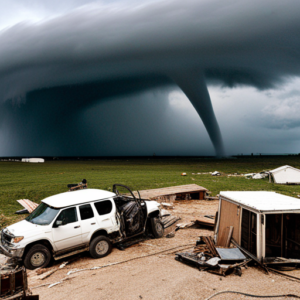
Tornadoes rank among nature’s most formidable forces, with potential wind speeds exceeding 300 miles per hour and wreaking havoc on homes, businesses, and communities. This piece delves into the atmospheric dynamics leading to tornado formation and the ongoing research enhancing our comprehension of these violent weather phenomena.
Formation and Conditions
Tornado genesis stems from specific atmospheric conditions—namely, the collision of warm, moist air from the Gulf of Mexico with cold, dry air from Canada, fostering unstable conditions ripe for severe thunderstorms. Within these storms, varying wind speeds and directions at different altitudes (wind shear) play a pivotal role, promoting the air column’s rotation and eventual condensation into a tornado.
Structure and Measurement
A tornado’s anatomy features a rotating air column, or vortex, visible as a funnel-shaped cloud laden with debris. Their intensity is gauged using the Enhanced Fujita Scale, ranging from EF0 (weakest) to EF5 (strongest), based on inflicted damage and wind speed within the vortex.
Tornado Watches vs. Warnings
Understanding the distinction is crucial for safety: a *tornado watch* signals potential tornado conditions, whereas a *tornado warning* indicates an imminent or occurring tornado, urging immediate shelter.
Safety Protocols
Preparedness involves staying informed, having a shelter plan, and knowing protective actions if caught outdoors or driving during a tornado.
Historical Impact
Historic tornadoes, such as the 1925 Tri-State Tornado and the 2011 Joplin Tornado, underscore the critical need for preparedness and awareness due to their devastating impact.
Research and Climate Change
Tornado chasing and research have enriched our understanding of tornado dynamics. Meanwhile, the potential influence of climate change on tornado patterns—including frequency, intensity, and geographic shifts—warrants ongoing study to adapt preparedness and response strategies effectively.
The intricate science behind tornadoes reveals the significance of continued research and preparedness in mitigating the impact of these awe-inspiring yet destructive storms. As our knowledge evolves, so too does our capacity to predict, prepare for, and protect against the formidable power of tornadoes.
Day_173 : Greta Thunberg at COP24 in 2018 : History again since Seven Suzuki in 1992
Just remember the Greta Tunberg speech and also remember Seven Suzuki speech. Personally, I think Seven Suzuki’s speech is more resonating.
Day_61 : Severn Suzuki, speaking at the Earth Summit in 1992
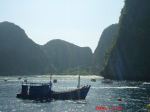
Day_172 : Hollywood Movie “The Beach” and The 2004 Indian Ocean Tsunami in Thailand
Past writings are to be disclosed little by little, with some changes.
>>>>>>>>>>>>>>>>>>>>>>>>>>>>
The Supreme Court of Thailand ordered 20th Century Fox Inc. and its local subsidiaries to restore the ecosystem of Phi Phi Island, acknowledging that the company degraded the environment around Phi Phi Lei Island for the filming of the Hollywood movie “The Beach” in 2000 on December 7, 2006. The film, starring Leonardo DiCaprio, has made great strides in the development of tourism on the island and displaced many tourists, but the island was one of the worst affected areas by the Indian Ocean Tsunami of late 2004, and many tourists lost their lives.
 Flyer: The Movie “Tha Beach”
Tourism development for economic development and environmental issues lay largely in the background of why Koh Phi Phi was one of the hardest-hit areas by the tsunami in Thailand.
It all started with the baht crisis that hit the Thai economy in 1997. In the early 1990s, the Thai government established the Ministry of Science, Technology and Environment and the Environmental Fund, enacted a number of environmental laws and enacted a national environmental boom, which began in the early 1990s. A prime example is a controversy over the alteration of the environment for Hollywood movies, known as “the beach controversy,” which began in 1998.
This was sparked by an attempt by a film crew to alter the landscape of Maya Beach on the island of Phi Phi Ley. For the filming of football game scenes, the sandy beach was widened by bulldozers, and non-indigenous coco palm trees were imported and planted on the beach to create an image of a tropical paradise. The Royal Forest Department’s decision to approve the alteration was a measure that went so far as to bend the law in order to attract international investment with the aim of reviving the Thai economy.
This has led to the neglect of nature conservation, and local NGOs and others have begun to investigate and prosecute the environmental degradation around the island.
The tsunami that struck Phi Phi Island on December 26, 2004, occurred in the midst of such tourism development.
Now, two years after the tsunami, the island of Phi Phi Lei and the surrounding areas have regained their natural beauty, having been cleared of the man-made nature created by the tsunami.
Mr. Songboon of TOT Krabi Province, a major telecommunications company in Thailand, said, “I’ve been watching Phi Phi Island for a long time, but the sea was the dirtiest just before the tsunami. He said with great emotion, “The beaches around the area after the tsunami have regained the beauty of 10 years ago. He is currently staying on Phi Phi don Island to set up an internet connection.
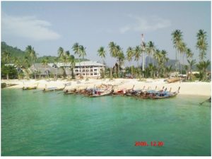
 Picture: Maya Beach
Mr. Spar, who runs a dive shop in the hard-hit Thongsai Bay, said, “For a while after the tsunami, we were in a vicious circle, with fewer customers and higher rates for the limited accommodations available to stay, and even fewer customers. However, now the sea itself is getting very clean, the city has recovered a lot, and the customers have returned. Management is getting a little better, too. and a glimpse of hope.
 Picture: Thongsai Bay
Supreme Court decision that seems too little, too late. It will be interesting to see how Phi Phi Island rebuilds and learn from the experience of the tsunami and its recovery process.
Reference:
Natural Disasters and Disaster Management in Thailand
Natural Disasters and Disaster Management in Thailand
Nikkan Berita (edited and rearranged for this post)
Nikkan Berita Writer’s Archive December 30, 2006
Day_171 : Past Interview Records – PTWC (Pacific Tsunami Warning Center) in Hawaii (2)
Interview Records at PTWC No. 2
2008.2.26 (Tue.) at 1000 am
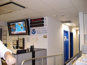
The records from the interview survey are shown below.
■ Science and technology
Many models of the tsunami have been developed. However, it is difficult to adopt because it is crucial whether it is practical or not.
■ Staff training
Only internal training is available.
■ A system where Civil Defense gives warnings to citizens.
There is a hotline to the provincial government and another one to the federal government.
■ Work shift
One person is always at the center for 24 hours.
8hr-4hr-4hr 4hr 16hrs are in shift
When there is a problem, three staff gather at the center.
■ Backup
The center’s backup is at the Alaska center and if Hawaii doesn’t work,. Alaska center can cover.
■ Relationship with media
Concerning the media, media is, in a sense, a partner.
Civil Defense needs 3 hours before the event to evacuate. for that reason, there are too many time constraints. The media is fast. However, there are various restrictions. To decide to proceed with the warning or not, the media has no such authority. Also, in the United States, the media is a business and not state-owned, so it could mislead. You must always pay attention to the points.
■ Resources
Before the tsunami damage of 2004, the conditions were very limited in terms of resources. A lot of money has been invested in this field since the beginning of the year. The function of the center has been improved because of that. The staff has increased. The 2004 event was a severe tsunami disaster, letting the world know the reality.
Related information . and Books
The following tsunami warning center provides the world situations on the map and list
U.S. Tsunami Warning Centers
Day_170 : The methodology of the Research on the communities and workers sustainability in the industrial complex area affected by the 2011 Chao Phraya Flood
Basically, we proceed with a top-down process for the research. The followings are the outlines of the procedures for the surveys: 1) Rojana Industrial Park and Japanese companies and their responsible persons 2) Communities: Community leaders, employees, and critical facilities and their responsible persons.
1) Rojana Industrial Park and Japanese companies and their responsible persons
The followings are the reasons why Japanese companies and why Rojana Industrial Park in the central region of Thailand are selected for the project. The first, 451 of 804 inundated companies in the central region of Thailand caused by the 2011 flood were Japanese related (Tokyo Marine & Nichido Fire Insurance Co., Ltd., 2011). The second, the Rojana Industrial Park, is one of the seven inundated industrial parks in the central region of Thailand. Rojana Industrial Park is also deeply related to the Japanese company because Rojana Industrial Park was established as a joint venture between Japanese (Nippon Steel & Sumikin Bussan Corporation) and Thai (Vinichbutr’s Group) companies in 1983. The Japanese target companies are mainly selected through the connections with the Japanese Chamber of Commerce Bangkok and Japan External Trade Organization (JETRO). The responsible persons are chosen totally up to the companies. The representative Japanese and Thai managers and persons in charge of BCP or risk management of the companies are chosen to meet our needs. We conduct focus group interviews and questionnaire surveys for the above persons and employees in the companies. Questionnaires are distributed and collected in the box in the canteen of the companies.
2) Communities: Community leaders, employees, and critical facilities and their responsible persons
A top-down approach in data collection is applied by gaining the necessary authorization from the senior-level officials such as Chief of DDPM Ayutthaya and Chief district office, which subsequently facilitated reaching out to Tambon and Mooban leaders through the District office. This approach proved useful in establishing the proper and assured contacts to conduct the surveys in the target area.
Firstly, we ask permission to do surveys from the Ayutthaya governor and the chief of the DDPM Ayutthaya office. Second, we are introduced to meet the target Amphoe Uthai chief and ask him to communicate with the four target Tambon leaders. Third, we asl Tambon leaders to introduce the thirty-five Muban leaders and also the persons in critical facilities in the area. After the process, we conduct the employees’ surveys. The target persons, 400, are randomly selected with the recognition of the Muban leaders based on the Yamane formula. We also proceed with the interview surveys to our prioritized twenty-five critical facilities acknowledged by the Tambon and Muban leaders. The representatives or the persons in charge of risk management in the critical facilities are required to answer the questions.