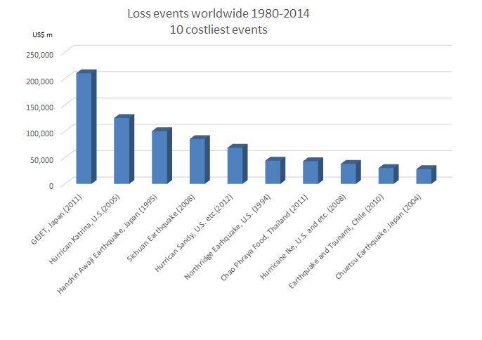
Day_137 : Aging Asia to Natural Disasters -Thailand(2)-

Day_68 indicates Thai population in 2012 was 64,460,000 and the proportion of those over 65 is 8.6 percent (11 percent in 2016) compared to 3.1 percent in 1970. This shows that Thailand is facing an aging society and the World Population Prospects* predicts this trend will accelerate. This situation is not exclusively in Thailand, but can likewise be viewed in almost all Asian nations. In addition, Asia is the most vulnerable in terms of natural disasters such as 7 of 10 of the deadliest natural disasters (1980-2014) took place in this region(Day_79). The World Bank mentions how Thailand faces the aging society from an economic development perspective, however, we also need to recognize this from a disaster reduction viewpoint. Okushiri island case can give us a significant insight(Day_75). This gives us a challenge of how disaster-resilient society can be established in the situation.

The World Bank notices**:
The Thai population is aging rapidly. The declining share of the working-age population will affect economic growth.
– As of 2016, 11% of the Thai population (about 7.5 million people) are 65 years or older, compared to 5% in 1995.
-By 2040, it is projected that 17 million Thais will be 65 years or older – more than a quarter of the population.
-Together with China, Thailand has the highest share of elderly people of any developing country in East Asia and Pacific.
-The primary driver of aging has been the steep decline in fertility rates, which fell from 6.1 in 1965 to 1.5 in 2015, as a result of rising incomes and education levels and the successful National Family Planning Program launched in 1970.
-The working-age population is expected to shrink by around 11% as a share of the total population between now and 2040 – from 49 million people to around 40.5 million people.
This decline in the working-age population is higher in Thailand than in all other developing East Asia and Pacific countries, including China.

https://disasterresearchnotes.site/archives/2785

https://disasterresearchnotes.site/archives/2753

* World Population Prospects
https://esa.un.org/unpd/wpp/

** World Bank, 2016
Thailand Economic Monitor – June 2016: Aging Society and Economy

Disaster data and statistics can be referred by the following link:
http://www.preventionweb.net/english/professional/statistics/

Day_136 : Disaster-Related Death (1)

Kobe Earthquake : 919 (22Dec.2015)
Great East Japan Earthquake and Tsunami : 3,472 (31Mar.2016)

What are the numbers?

The above numbers are the numbers of disaster-related deaths. The disaster-related death means the death which is not directly caused by hazards such as sickness, disease, and committing suicide. Especially , the disaster-related death number of GEJET is still increasing even 5 years after the disaster. This reflects aging society. The elderly people tends to have sickness and losing hope without family members. Local governments have been working hard to prevent such tragedies. They are visiting and watching the victims individually.

Day_135 : Thailand Disaster Chronology (2) 2013 – 2016

The collected information on Thailand natural disasters 2001-2011.
This is a tentative version.

Date Places(Provinces, etc) Disaster Type Situations
2013.06 Phuket, Ranong, Nan, Phang Nga, Trang, Satun, Krabi Flood Torrential rain has been constant in the south for around 3 or 4 days already, flooding streets and town centers. Outside the towns, many roads have been made impassable by mudslides and floods. The western coast of south Thailand suffered the most, especially the provinces of Phuket, Ranong, Nan, Phang Nga, Trang, Satun and Krabi. Six houses were damaged by mudslides in Nan province, with one person reported as missing.All seven districts in Satun Province have been declared a disaster zone after they had been hit by flash floods. There have been reports that as many as 9,000 homes have been affected.
2013.07.05 Phang-Nga Flood Nearly 13cm of rain has fallen in a 24 hour period on 4th July 2013 in the Phang-Nga province. Particularly badly affected was the Takua Pa district. Other areas of southern Thailand have also seen heavy rainfall. Floods and landslides killed  one person and many houses  and buildings were damaged in Phang-Nga.
2013.07.18 Trat, Ranong Flood Heavy rain has caused flooding in Trat and Ranong provinces. Over 500 residents of Trat province have been affected.
2013.08.01 Chiang Rai, Kanjanaburi, Tak, Nan, Payao, Sakon Nakorn, Prajinburi Flood The recent floods had affected nearly 20,000 homes across 7 provinces in Thailand. According to DDPM, 18,788 homes in Chiang Rai, Kanjanaburi, Tak, Nan, Payao, Sakon Nakorn and Prajinburi have been affected by flash floods as heavy rains continue raging across these provinces.
2013.09.17 30 provinces of Thailand Flood Two million people in 30 provinces of Thailand have been affected by floods since 17 September 2013.
2013.11.26 Surat Thani Flood Four districts in the Surat Thani province have also been declared disaster zones, with 4,070 households affected and 41 roads and 21 bridges left damaged or impassable.At least five people have reportedly died in the flood.
2013.12.05 Southern Thailand Flood Floods in Thailand’s South have intensified with heavy rains lashing towns and water levels rising. Water has been flowing down from nearby mountain ranges to Mueang district and affected approximately 16,500 households.
2013.12.07 Prachuap Khiri Khan, Chumphon, Ranong, Surat Thani, Satun, Yala and Pattani, Nakhon Si Thammarat, Songkhla, Phatthalung, Trang, Narathiwat Flood On Saturday 7 December, Thailand’s Disaster Prevention and Mitigation Department announced that floods had started to recede in the seven affected of Prachuap Khiri Khan, Chumphon, Ranong, Surat Thani, Satun, Yala, and Pattani,the department also stated that flooding remains in Nakhon Si Thammarat, Songkhla, Phatthalung, Trang and Narathiwat provinces, affecting around 125,000 people.
2013.12.16 Southern, Central, and Northern Flood Thailand’s Department of Disaster Prevention and Mitigation (DDPM) announced that the floods that had affected much of the country’s southern region have receded in 10 provinces, but remain in Phutthalung and Trang. The DDPM said that as many as 6,000 people are still affected by flooding in these two provinces.Northern and central areas of Thailand have been affected by flooding throughout the monsoon.Heavy rainfall around 21 November led to severe flooding across 12 provinces, resulting in 20 deaths. The worst affected area was Nakhon Si Thammarat province, where as many as 6 people died.
2013.12.16 Loei, Tak, Nan, Chiang Mai, Nakhon Phanom, Nong Bua Lamphu Cold Spell The cold spell has affected the north of the country, affecting over 1 million people in the six provinces of Loei, Tak, Nan, Chiang Mai, Nakhon Phanom, and Nong Bua Lamphu, all of which have been declared disaster zones as a result of the cold temperatures.
2014.01.13 Narathiwat Flood Floods have struck in the Su-ngai Kolok and Waeng districts of Narathiwat in Thailand following continuous rainfall throughout last week.The rainfall increased levels of the Buketa Canal until it eventually overflowed, flooding around 20 villages and leaving around 1,088 homes under 50cm to 100cm of water.
2014.05.05 Chaing Rai Earthquake An earthquake with a magnitude of 6.3 on the Richter scale struck the northern province of Chiang Rai at 6.08pm Monday, May 5.The epicenter was located at a point 9 km (6 mi) south of Mae Lao District, 27 km (17 mi) southwest of Chiang Rai, Thailand.Windows, walls, and roads as well as temples all suffered damage from the quake. It was the strongest earthquake ever recorded in Thailand according to National Disaster Warning Center. In Phan district of Chiang Rai, a road was split by serious cracks. A Buddha statue’s head at the Udomwaree Temple fell off due to the quake and a residential building of the temple suffered exterior cracks and ceiling damage.
2014.07.24 Sakon Nakhon, Prachin Buri, Si Sa Ket, Ubon Ratchathani,Yasothon Flood Thailand’s Department of Disaster Prevention and Mitigation(DDPM) stated earlier today that, after several days of steady rain, flooding is affecting the 5 provinces of Sakon Nakhon, Prachin Buri, Si Sa Ket, Ubon Ratchathani and Yasothon. Ubon Ratchathani saw over 80 mm of rain fall 24 hours between 22 and 23 July 2014. Sakon Nakhon province was one of the worst hit, where floods have affected around 4,000 families. Elsewhere, flooding has damaged homes and roads in Si Sa Ket and Ubon Ratchathani provinces. Access to several parts of Si Sa Ket has been difficult for the last few days. At one stage flood waters were so high the Provincial Electricity Authority (PEA) had to cut power supply in the Benchalak district as a safety measure.
2014.02 Buriram, Sakon Nakhon Drought Thailand’s northeastern provinces of Buriram and Sakon Nakhon are being plagued by the worst drought in decades and are in urgent need of assistance.
2014.07.10 Chiang Rai Flood, Landslide The northernmost province of Chiang Rai has been hit again by landslides and flash floods following three days of abundant raining. As many as a thousand families in 8 districts of the province have reportedly been afflicted.
2014.07.21 Northeastern Provinces Typhoon Rivers across several communities in northeastern Thailand have overflowed due to the effects of Typhoon Rammasun, which has caused heavy rains throughout the area.
2014.7.23 Sakon Nakhon, Prachin Buri, Si Sa Ket, Ubon Ratchathani, Yasothon Flood On 23 July, the 5 provinces of Sakon Nakhon, Prachin Buri, Si Sa Ket, Ubon Ratchathani and Yasothon were badly affected by flooding.
2014.07.30 Sakhon Nakhon, Ubon Ratchathani Flood Due to the heavy rainfall in the Northeast, flooding has occurred in Sakhon Nakhon and Ubon Ratchathani provinces,Thailand, affecting 19,183 households
2014.7.31 Amnat Charoen Flood The Mekong river in the north eastern Thai province of Amnat Charoen has overflowed and submerged several villages on 31 July 2014, damaging over 1,000 houses.
2014.8.21 Nan Flood Heavy rain in Nan province in northern Thailand caused local rivers to overflow earlier this week, flooding several districts in the province. Further flood warnings have been issued for 20 provinces, especially in northern and north eastern areas.Flooding has particularly affected the districts of Thung Chang, Muang and Song, where around 50 houses and areas of farmland have been damaged.
2014.09.01 17 Provinces Flood Thailand’s Department of Disaster Prevention and Mitigation (DDPM) reported on Monday 01 September 2014 that at least 17 provinces have been affected by recent flooding. Six people have been killed and at least 1 person remains missing.
2014.09.05 Nan, Shkhothai, Chaiyaphum, Tak, Nakhonsawan Flood Due to heavy rainfall, several provinces in Northern Thailand experienced flooding. As of 5 September, the affected areas are 1. Nan Province: Nanoy and Namoen district 2. Shkhothai Province: Muang, Srisuehanalai Srinakorn and Tung Saleam. 500 houses are still inundated. 3. Chaiyaphum Province: 80 houses are submerged. 4. Tak Province 5. Nakhonsawan Province: 30 houses are inundated. Impact: 7404 families or (estimated) 15000 people 17479 ha agricultural fields damaged 3000 ha of rice field damaged.
2014.09.06 28 Provinces. Deaths occurred in Kamphaeng Phet, Mea Hong Son, Chiang Rai, Nakhon Si Thammarat, Phayao, Phrae, and Sukhothai Provinces. Flood Thailand’s Disaster Prevention and Mitigation Department (DDPM) states 07 September 2014, that flooding that has affected at least 28 provinces in the country since late August, has resulted in the deaths of 10 people and 14,562 houses had been affected by the floods in over 700 villages.The deaths occurred in the provinces of Kamphaeng Phet (2), Mae Hong Son (2), Chiang Rai (2), Nakhon Si Thammarat, Phayao, Phrae and Sukhothai.
2014.09.29 Chiang Mai and Chai Nat Provinces Flood Due to continuous heavy rain, Fung District of Chiang Mai is affected by flood, Chai Nat province was also affected. Impact: 55houses damaged 94 houses affected in Chai Nat province.
2014.10.01 Chantaburi Province Flood Due to heavy rainfall, flood is affecting Chantaburi Province. Impact: 100 families affected.
2014.10.02 Chiang Mai and Chai Nat Provinces Flood Heavy rainfall has caused deadly floods in northern Thailand over the last few days. The heavy rain has moved south, to affect central and southern areas of the country.Chiang Mai Province faced continuous heavy rain and flash floods between 28 September and 01 October 2014. Three people tragically drowned in the flooding in Fang District. More than 50 homes in the district have been damaged by the floods. In Chai Nat Province, flooding was so severe that authorities had to make emergency rescues in Hunkha District. Nearly 100 homes have been damaged on the province.
2014.10.07 Petchaburi, Rachaburi, Prachuap khiri kham, Krabi, Satun, Surathani Flood Due to heavy rain since 6 October 2014, several provinces in central and south of Thailand have been affected provinces include: Petchaburi(6districts),Rachaburi(2 districts), Prachuap khiri kham, Krabi(2 districts), Satun(5districts), Surathani(2districts). Impact : more than 4700 families or more than 20000 people affected(estimated)
2014.10.20 Lampang Province Flood Heavy rain has caused the Lam Huai Mae River to overflow. Consequently, flood inundated more than 200 houses in Thoen District, Lampang Province. Impact: over 200 families were affected more than 200 houses were inundated.
2014.10.22 Lampang Province Flood Floods in 5 villages in Lampang Province, Thailand have affected 200 families. NNT (National News Bureau of Thailand) are reporting that the Lam Huai Mae Wa River overflowed its banks causing flooding in Thoen District in the northern province of Lampang, earlier today 22 October 2014.Around 200 families in 5 different villages in the area have been severely affected, although no injuries have been reported. Homes of the families are said to have been completely inundated and officials from Thailand’s Disaster Prevention and Mitigation Department (DDPM) are coordinating distribution of food, water and other supplies.
2014.11.07 Pattani, Nakhon si Thamamarat and Surat thani Flood Due to continuous heavy rainfall, flood was affecting several southern provinces including Pattani(Muang), Nakhon si Thamamarat (Phra phrom, Chang Klang) and Surat thani. Impact: 2408 households or 7237 people were affected 2000 acres of agricultural lands were inundated.
2014.11.10 Trang Flood Heavy rain has generated flashflood incident in Trang Province. The consecutive days of rain has created flooding in southern province. Impact: Over 200 families were affected in Trang 5,000 ha of farmland have been submerged.
2014.11.14 Trang, Nakhon Si Thammarat Flood Trang Province:Trang province has been one of the worst affected areas after persistent heavy rain over the last 4 days caused flash floods across several southern provinces.Around 1,000 villagers in Trang have been evacuated since the flooding began. Houses and farmland have been damaged. The flood water level was almost two meters high, according to NNT.

Nakhon Si Thammarat:At least 5 districts – Chawang, Chang Klang, Pipoon, Lan Ska, and Phra Phrom in Nakhon Si Thammarat experienced severe floods. More than 4,400 households and 12,000 people have been affected in the province.

2014.12.14 7 Provinces in the South Flood, Landslide Since 14 December 2014, Thailand’s seven provinces in the south have been affected by floods and landslides. Seven people died and three were injured.
2014.12.15 Nakhon Si Thammarat, Phatthalung Flood Floods in the southern Thai provinces of Nakhon Si Thammarat and Phatthalung have forced evacuations in as many as 50 villages, some of which are under more than 1 meter of water. One person is reported as missing after being swept away by the floods in Phrom Khiri district, Nakhon Si Thammarat.
2014.12.17 Narathiwat, Yala, Nakhon Si Thammarat, Phatthalung Flood Narathiwat:National News Bureau Thailand (NNT) say that floods in Narathiwat have been caused by heavy rain over the last 4 days has and run-off from the Sankalakhiri mountain range flowing down to the Su-ngai Kolok River. Houses along the river have been inundated. Flooding has also affected over 300 families in the districts of Sukhirin, Waeng and Su-ngai Kolok.

Yala:Many low-lying areas of the province are already seeing some flooding, and more is expected.

Nakhon Si Thammarat and Phatthalung: Floods struck in the provinces of Nakhon Si Thammarat and Phatthalung. Two people have been reported as missing after being swept away in the floods – one in Nakhon Si Thammarat, the other in Phatthalung.

2014.12.19 Southern Provinces Flood Heavy rain and flooding has continued in southern Thailand and is now also affecting areas along the Thailand-Malaysian border. Several southern provinces in Thailand have been under water for the last week.Across the region, a total of four people has been reported as killed in the floods and 14,000 people evacuated (12,000 in Malaysia). Two people remain missing in the floods in Thailand.
2015.01.08 Bangkok Flood In Bangkok, commuters faced a Monday morning rush hour driving in flood water up to 50 cm deep in some areas.A heavy downpour and thunderstorm lasting 5 hours dumped over 100 mm of rain on the city in the early hours between 2 are and 5 am. Some schools and colleges have closed.
2015,04.07 8 Provinces Storm Seasonal storms pounded about 50 villages in 11 districts of eight provinces, damaging more than 900 houses.
2015.08.06 North, North East, and South
Nakhorn Phanom
Flood Several areas in the North, North East and South of Thailand have reportedly been flooded by overflowing rivers after several days of rainfall. In Nakhon Phanom, more than 3,000 homes and 30,000 rai of rice paddies have been inundated.
2015.08.06 Nakhon Phanom Flood In Nakhon Phanom, more than 3,000 homes and 30,000 rai of rice paddies have been inundated in Sri Songkram district after the Songkram River overflowed the embankment and flooded surrounding areas. Residents were forced out of their homes and had to take refuge on the street.
2016.03   Drought The worst drought in 50 years in being predicted for Thailand in 2016. The agricultural sector will bear the largest impact, as the quantities of many agricultural products fall, especially rice, tapioca, sugarcane, and sugar.
2016.06.21 Bangkok Flood Wide areas of Bangkok, Thailand, were flooded on 21 June after a period of heavy rain across the city.The flooding brought traffic to a standstill forced some schools and businesses to close. The Department of Disaster Prevention and Mitigation (DDPM) stated that heavy rains during the evening of 20 June caused flooding in 36 areas of Bangkok, leaving streets under 60cm of water in some areas.
2016.09.06 Phang-Nga Flood The floods have affected areas of Phang Nga Province.The worst hit area is the village of Ban Bang Yai Village in Taku Pa District, where at least 40 houses have been damaged and left without drinking water. Vehicles, crops, and livestock have also suffered damage. No injuries or fatalities have been reported, however.
2016.10.07 Nakornsawan Province Flood 3 people have been killed by floods in Nakornsawan province. Wide areas of farmland have been submerged and 27,000 houses inundated.Flooding is affecting a total of 14 provinces across the country.Many areas have reported persistent heavy rain over the last 2 weeks. Ayutthaya province in particular is seeing some severe flooding, with around 22,000 homes inundated as well as a number of important historical buildings and temples.

Source: ADRC, Reliefweb, BBC, JICA, etc. (The source will be indicated)

Day_134 : Thailand Disaster Chronology (1) 2001-2012

The collected information on Thailand natural disasters 2001-2011.
This is a tentative version.

Date Places(Provinces, etc) Disaster Type Situations
2001.8.21 North, upper central, northeastern and eastern provinces Flood A flash flood swept down a mountainside through villages in Lomsak district
death:164 people
damage estimate :24.4 million dollars
2001.12.24 Southern Provinces Flood Thousands of people in southern Thailand fled their houses after heavy rains triggered floods.
2002.4.29 The Thailand’s largest refugee camp near the Myanmar border Storm A freak tropical storm has killed five people at the refugee camp. The storm made damaged about 300 bamboo shelters as it tore through the camp.Around 40,000 Karen people live in shelters near the Myanmar border.
2002.9.3 Northern Provinces Heavy Rain At least 14 people were killed and more than 20 were missing after their makeshift houses on the banks of an overflowing stream collapsed after heavy rain.
Death:39 people
Damaged house: 150,000
2002.9.18 Northern Provinces Mud Slide Some 800 people narrowly escaped a huge mudslide in northern Thailand on Tuesday as it swept through three villages in a tangle of uprooted trees and destroyed buildings, a district official said.
2002.10.4 Bangkok Flood Residents of the Thai capital, Bangkok, are bracing themselves for severe flooding following forecasts that floodwaters coming from the north of the country.
2003.10.26 Eight Provinces Flood Five days of heavy monsoon rains have brought severe floods to Thailand, killing a 13-year-old boy, forcing hundreds of people from their homes and disrupting road and rail transport, officials said.
Dead: 1 person
Affected: at least 200,000 people
(in 8 provinces)
Evacuated: more than 1,600 people
2003.12.14 Southern Provinces Flood Floods in Thailand have killed at least eight people and damaged tens of thousands of homes.
2004.12.24 Krabi, Trang, PhangNa, Phuket, Ranong, Saturn Tsunami On 26 December 2004, Tsunami occurred off the Sumatra Island killed 5,395, affected 58,550, and whose total loss was US$ 399.78 million in Thailand
2005.8.31 Northern Provinces (Chiang Rai, Chiang Mai and Mae Hong Sorn Provinces) Flood Over 100,000 families have been affected by severe flooding in Northern Thailand in the middle of August. Torrential rains which earlier in August hammered Chiang Rai, Chiang Mai and Mae Hong Sorn inundated more than 4 500 villagers’ homes in these three provinces alone leaving 11 people dead and making several roads impassable to small vehicles.
2005.12.18 Southern Provinces Torrential monsoon rains Torrential monsoon rains have wreaked havoc across Thailand’s south, killing 12 people and leaving two missing in the past week, officials said on Sunday. Seven of the victims died in two mudslides.
2006.05.23 Northern Provinces Flood,Mud Slide Heavy monsoon rains unleashed flash floods and mudslides in northern Thailand which killed at least 10 people, left 47 missing and thousands homeless, officials said on Tuesday.
2006.10.10 43 provinces in the country’s north, north-east and central Thailand Flood More than 32 dead in Thai floods since August 2006, reported on October 10.
2007.04.14 Trang Flood Flash floods killed at least 23 holidaymakers and injured more than 20 at three waterfalls in the southern Thai province of Trang on Saturday as they celebrated the Thai New Year, disaster officials said.
2008.04.27 Thak Flood Rains have continued pouring in Thak province, Thailand at least four consecutive days. Over 1,000 people are currently homeless.
2008.8.15 Nakhon Phanom Flood The disaster prevention special command center in Nakhon Phanom province is in the midst of assessing the damage caused by inundation in 12 districts. More than 100,000 people have been affected by flooding. Meanwhile, the death toll has reportedly stood at 1.
2008.09.08 North and Northeast Provinces Flood Heavy downpours due to a low-pressure trough and the south-western monsoon in the past week have triggered more flash floods and inundated villages and farmland in north and northeast Thailand. According to disaster officials, five people have been killed, 114,345 (34,182 families) have been affected.
2008.10.01 Northern, north-eastern and central provinces Heavy Rain The death toll from floods triggered by heavy monsoon rains has risen to 23, while nearly 230,588 people have been treated for water-related illnesses and injuries.
2008.09.31-10.01 Si Sa Ket Province Typhoon Typhoon Mekkahla hit between 31 September and 1 October 2008. The cyclone caused torrential rains which killed 32, affected 2,864,484 and whose total loss was US$ 21.6 million including Vietnam.
2008.11.19 Southern Provinces Flood 201,434 people affected, 10 people died and 190 families homeless (685 persons) from heavy rain in southern Thailand.
2008.12.08 Yala Flood After heavy rains in southern Yala province, Thailand, the Disasters’ Prevention Special Command Centre in Yala has issued warnings on 8 December 2008 to the people in the area to be cautious of potential hazards and flash floods after over 3,000 local families being affected.
2009.11.07 Southern border provinces Flood The flooding which started in the southern border province in Thailand so far killed 10 people
2010.08.13 Lampang Flood The flood struck the northern province of Lampang on Friday night (13 August 2010) with the water level as high as one meter. Over 1,200 households and 36 villages in 7 districts have been affected.
2010.10.16 Nakhon Ratchasima Flash Flood Nakhon Ratchasima has been ravaged as flash floods wreak havoc in the Northeast and Central Plains following heavy weekend monsoon rains.
2011.03 47 Provinces Drought The Department of Disaster Prevention and Mitigation, Thailand announced drought in 47 provinces.
2011.03.27 Southern Provinces Flash Flood Since 23 March 2011 there has been a prolonged heavy rainfall causing flash floods in many provinces in the South.
2011.07-2012.02 Provinces of Northern, Northeastern and Central Thailand along the Mekong and Chao Phraya river Flood Severe flooding occurred during the 2011 monsoon season in Thailand, beginning at the end of July and ceasing mid-January 2012. The flooding affected the provinces of Northern, Northeastern and Central Thailand along the Mekong and Chao Phraya river basins, as well as parts of the capital city of Bangkok. It resulted in a total of 813 deaths, 9.5 million people affected and economic damage of USD40 billion.
2011.08.03 North and the northeast provinces Tropical Storm, Flood Tropical Storm Nock Ten has caused continuous rainfalls in the north and the northeast of Thailand, causing floods in 15 provinces.
2012.06.06 Surat Thani Heavy Rain, Flood Continuous rain has caused flooding in five districts in Surat Thani province of southern Thailand, affecting 8,500 households and over 27,000 residents.
2012.09.12 Northern Provinces Flood Thousands have fled their homes in Northern Thailand after heavy rain caused a major river to overflow at the start of September.

Source: ADRC, Reliefweb, BBC, JICA, etc. (The source will be indicated)

Day_133 : Science, Technology, Population, and Lessons for DRR

Japanese people have tended to trust the government and science & technology so much.
These are one of what we learned from recent disasters. After the second world war, Japanese gov. has built high sea walls along the coastline especially potential risk areas all over Japan. We have also developed warning systems along with rapid economic growth. Not only those, but we have also developed soft countermeasures such as disaster education and training, especially after the 1995 Kobe Earthquake. After the Great East Japan Earthquake and Tsunami (GEJET) disaster, we have realized what has happened because of our over trust to the government and science&technology. This is why Japanese gov. has particularly focused on the community since the disaster, establishing a new frame on the community disaster planning in the disaster countermeasure basic act. The recovery plans on the affected coastal communities tended to change more integrated manners and so did disaster countermeasures than before, looks like turning back to the time when we did not have advanced science and technologies.

We need to know the limitations of the gov. and science&technology’s roles. We also can consider the demographic change to do the job for disaster risk reductions. For example, Japan is facing a severe aging society, so our government resources will be decreasing to cover the situations. We need to have more self-help and mutual help than public help.

Learning from the lessons and past wisdom with those considerations is also very important. “Inamura no Hi” is one of the important lessons we can learn from the past.

http://disasterresearchnotes.site/archives/2720

“Inamura no Hi” is a story of a man who noticed a precursor of a large tsunami at the earliest stage and led village inhabitants to a higher ground by burning harvested rice sheaves. This story was based on a true story at the time of Ansei-Nankai Tsunami (1854), which claimed around 3,000 lives in the coastal areas of Western Japan (ADRC).

Hirokawa Town’s video well explains the background of the story in short and their tsunami disaster education.


Day_132_Area BCM (1)

In 2011, Great East Japan Earthquake and Tsunami (GEJET) disaster and the Chao Phraya River flood disaster made huge economic damages. They are in the top 10 costliest natural disasters (The very top and the 7th) in the world as you can see the following table.

top10costliest_natdisasters

Source: NatCatSERVICE/Munich RE 2016

From the historical point of views, the disaster trends from human sufferings to economic damages. The following figure shows the economic damage tendency is increasing with time and we can see the year of 2011 was an outstanding.

disaster-trends-cost

Source: EM-DAT

Especially, the globalization of the economic activities reflect these damages.In the event of large-scale disaster, a business sector is limited in its abilities to cope with disaster without the cooperative approach taken by the stakeholders of the public and private sectors in those areas.

With this situation, the concept of the Area Business Continuity Management (Area BCM) was revealed. This is a cooperative approach by those who wish to improve capacity for continuity and/or early recovery of business in their area in the event of disasters that affect the entire area(AHA CENTRE et al., 2015).

[Reference]
AHA CENTRE, JICA, et al., (2015) Planning Guide for Area Business Continuity: Area BCM Toolkits Version 2

sponsored link

Day_131 : Italy-Recent earthquake and past earthquake disasters (2)

CNN: (October 30)A powerful 6.6-magnitude earthquake rocked central Italy on Sunday morning, injuring at least 20 people, in the strongest tremor to hit the country in more than three decades. The earthquake follows tremors last week and comes on the heels of a devastating quake in August, which killed nearly 300 people and flattened entire villages.

Asian Disaster Reduction Center (ADRC) still does not list this earthquake situation.This earthquake is severer than this August Earthquake(Day_107). Earthquakes in Italy happened mostly central and southern part of Italy around the

http://disasters.weblike.jp/disasters/archives/3081

Natural disaster trends are usually from human sufferings to economic damage. In Italy, main natural disaster is the earthquake and follow the trends as you can confirm below.
However, recent earthquake disasters in Italy are so severe.  With this August earthquake, the number of casualties would be over 550. The disaster recovery is also the issue. As mentioned in Day_107, “Italy has a poor record of rebuilding after quakes. About 8,300 people who were forced to leave their houses after a deadly earthquake in L’Aquila in 2009 are still living in temporary accommodation(Reuters).”

Table 1 and Table 2 show the 1900-2016 top 10 deadliest and costliest disasters in Italy (EM-DAT).

Table 1  Totals deaths
Italy deadliest

Table 2  Total damage
Italy costliest disasters

Day_130 : Natural Disasters in China (2) – Two Earthquake Disasters


Two Earthquakes
Yang Zhang William Drake, et al. (2016)* indicates interesting views on two earthquakes disaster recoveries, the 1976 Tangshan earthquake and the 2008 Wenchuan earthquake. The point is, why the 2008 Wenchuan earthquake recovery was so rapid compared to the 1976’s earthquake.
However, the paper could add more about the total background changes of China such as society, economy, and politics. The china has changed dramatically after the 1976 from historical viewpoints.

The Tangshan earthquake is one of the deadliest disasters in the world and the Wenchuan earthquake is one of the top ten costliest disasters in the world also. Munich Re ranked the Wenchuan as the top four costliest disaster after the Japanese Tsunami (2011), the Hurricane Katrina (2005). and the Kobe Earthquake (1995). The number of deaths caused by the Tangshan is still controversial because of the Chinese government’s political climates at the time.

A Comparison of the two earthquakes

tanchanwenchan
Yang Zhang William Drake, et al. (2016)

The Rapid Disaster Recovery after the 2008 Wenchuan earthquake
Yang Zhang William Drake, et al. (2016) describes the following points, historical and socio-economic contexts, why the 2008 Wenchuan earthquake recovery was so rapid compared to the 1976’s earthquake.

[Historical context]

  1. The Chinese government drew lessons from its handling of the Tangshan earthquake recovery. The government emphasized the importance of planning for coordinated reconstruction.
  2. China had established a strong planning institution to support its rapid growth agenda since the economic reform began in the late 1970s. The contrast of recovery planning between the two earthquakes highlights the notion that a pre-existing planning institution and pre-existing policy documents that describe development visions for a disaster area.

[Socio-economic context]

  1. China’s ability to promptly fund the earthquake recovery was far superior in the 2000s. China’s annual GDP in the year prior to the Wenchuan earthquake was 3.494 trillion USD 2007, which was 22 times its GDP in 1975.
  2. The earthquake happened less than three months before the Beijing Olympic Games. It was in the government’s best interest to move swiftly with the response and recovery to ensure social stability for the Olympic Games.
  3. The global economic downturn of 2008 might have also played a role in speeding up the earthquake recovery. To stimulate the economy, heavy investment in the earthquake recovery became a convenient policy option.

However, many things can be added about the above points such as the acceptance of international aids (Day_95).

http://disasters.weblike.jp/disasters/archives/2971


This rapid recovery from Wenchuan reminds us the Japanese historical trends  from 1945 to 1959, especially after the Typhoon Isewan in 1959. The Haiti’s cases, 2010 Earthquake and 2016 Hurricane Matthew also can be found as the same analogy (The below related articles across the web).

The Meanings of the Lessons
We cannot experience the disasters so often, of course, we do not want to have disasters. This is why we should learn from the past disasters and this is what we can do all the time.

*Yang Zhang William Drake, et al. (2016) Disaster Recovery Planning after Two Catastrophes: The 1976 Tangshan Earthquake and the 2008 Wenchuan Earthquake, International Journal of Mass Emergencies and Disasters, 34(2):174-203

[ad#ads1]


Day_128 : World Disaster Chronology-1992-93

Date Place Disaster Type Situations
1992.01- Bangladesh Cold Wave Over130(DM)
1992.02.01 Turkey Avalanche Over 300(DM)
1992.03.13 Turkey, Northeastern Inland Earthquake M6.8, 1992 Erzincan earthquake *, 500(DM)
1992.03- Brazil Landslide 150(DM)
1992.07- China Heavy Rain, Flood Over 1,000 (DM)
1992.08.19 Kyrgyzstan Inland Earthquake M7.4, Over75(DM)
1992.08- US, Southeastern Typhoon, Flood Hurricane Andrew, Over 35(DM)
1992.09.02 Nicaragua Submarine Earthquake M7.2, Over110(DM), Tsunami
1992.09- Afganistan Heavy Rain, Flood Over 3,000(DM)
1992.09- Pakistan Heavy Rain, Flood Over 1,600(DM)
1992 Africa, Southeastern Drought Over ten million people are affected. Several million people were reported dead by hunger starvation.
1992.09- France, South Heavy Rain, Flood Over 110 (DM)
1992.10.12 Egypt, North Inland Earthquake 1992 Cairo earthquake, M5.9, Over 550(DM), Panics in the capital city
1992.11- India Heavy Rain, Flood Over 230(DM)
1992.12- Bolivia Landslide Several hundreds (DM)
1992.12.12 Indonesia, East Submarine Earthquake 1992 Flores earthquake, M7.5-7.7, Over 2,500(DM), TsunamiHeight 25m
1993.04-10 Great Flood of 1993 US, Midwest 32(D),Property damage 15-20 billion USD
1993.07.12 Japan, Hokkaido (Okushiri Island) Submarine Earthquake Hokkaido Nansei Oki Earthquake**, M7.8, 230(DM), TsunamiMax Height 32m
1993.08- Japan,  Kagoshima Heavy Rain, Flood 1993 Kagoshima Heavy Rain, 79(DM), Injured over150,Destroyed approx.800, Inundation over 21,000
1993.09- Japan Typhoon, Flood 48(DM), Injured260, Destroyed approx.1,800, Inundation over 10,000
1993.09.30 India, South Inland Earthquake 1993 Latur earthquake, M6.2, 7600-9,800DM
1993.10.13 Papua New Guinea Inland Earthquake M7.0, Over60(DM), Landslide

DM: The number of Dead and Missing

* 1992 Erzincan earthquake

http://disasters.weblike.jp/disasters/archives/2806

** Okushiri Island

http://disasters.weblike.jp/disasters/archives/2753

[ad#ads1]


Day_127 : World Disaster Chronology-1990-91

Date Place Disaster Type Situations
1990.01- Indonesia Heavy Rain, Flood Over 130(DM)
1990.03- Bangladesh Heavy Rain, Flood 170(DM)
1990.04- Africa, East Heavy Rain, Flood Over 140(DM)
1990.04.26 China, Qinghai Inland Earthquake M6.5, Over 120(DM) Landslide
1990.05- India Cyclone, Flood Over 3,000(DM)
1990.05.29 Peru, Central Inland Earthquake M6.5,130-200 (DM),Landslide
1990.06- Japan, Kyushu Heavy Rain, Flood 27(DM),Injured 80, Destroyed approx.500, Inundated over 42,000
1990.06.21 Iran, North Inland Earthquake 1990 Manjil–Rudbar earthquake*1),M7.3-7.7, 30,000-50,000(DM), destroyed several towns 
1990.07.16 The Philippines, Luzon Inland Earthquake 1990 Luzon earthquake*2), (M7.8),
1,700-2,400 (DM)
1990.08- China Heavy Rain, Flood Over 300(DM)
1990.08- The Philippines Typhoon, Flood 230(DM)
1990.09- Korea Heavy Rain, Flood Over 130(DM)
1990.09- Japan, Northeast Typhoon, Flood 40(DM), Injured 130, Destroyed approx.16,000, Inundation Over18,000
1990.10- Bangladesh Cyclone, Flood Over 3,000(DM)
1990.11- Tha Philippines Typhoon, Flood Over 350(DM)
1991.02.01 Afganistan Inland Earthquake M6.4,200-700(DM)
1991.04.22 Costa Rica Inland Earthquake M7.6, 70(D) with Panama
1991.04.29 USSR(Georgia) Inland Earthquake M7.0, Over100(DM)
1991.04- Bangladesh Cyclone, Flood 1991 Bangladesh cyclone*3), Over 139,000(DM). This disaster was among the deadliest tropical cyclones on record. 
1991.06- Japan, Kyushu Volcanic eruption Mt.Unzen Volcanic eruption*4),Pyroclastic flow,Over 40(D)
1991.06- The Philippines, Luzon Volcanic eruption Mt. Pinatubo Volcano eruption*5), 700-1000(DM)
1991.06- Pakistan Heat wave Over 300(DM)
1991.06- China Heavy rain, Flood Over 400(DM)
1991.07- India Heavy rain, Flood Over 900(DM)
1991.07- China Typhoon,Flood 200(DM)
1991.08- Korea Typhoon,Flood 100(DM)
1991.09- China Landslide Over 270(DM)
1991.09- Japan, all areas Typhoon,Flood 1991 Typhoon No.19, 62(DM)*6), Injured1,500, Destroyed approx.170,000, Inundation over 22,000
1991.10.20 India, North Inland Earthquake M6.8-7.0, 7702,000(DM)
1991.11- The Philippines, Central Typhoon, Flood Over 6,300(DM)*7)
1992.01- Bangladesh Cold Wave Over130(DM)

DM: The number of dead and missing.

1) Iran is one of the most vulnerable country on earthquake disasters.
The below Day_81 can be checked.
2) Buguio city was severely hit by this earthquake. The city is also vulnerable to landslide disasters. 2009 Typhoon Pepeng hit the Buguio city. There were some issues in this city. Urbanization is the one of the causes.
NIED natural disaster research report
3) Some past posts can be referred. The below Day_117 can be checked.
4) Some past posts can be referred.The below Day_65 can be checked.
5) A huge cloud of volcanic ash and gas rises above Mount Pinatubo, Philippines, on June 12, 1991. Three days later, the volcano exploded in the second-largest volcanic eruption on Earth in this century.Following this Mount Pinatubo’s cataclysmic June 15, 1991, eruption, thousands of roofs collapsed under the weight of ash made wet by heavy rains (see example in photo above). Ash deposits from the eruption have also been remobilized by monsoon and typhoon rains to form giant mudflows of volcanic materials (lahars), which have caused more destruction than the eruption itself(http://pubs.usgs.gov/fs/1997/fs113-97/).
6) Itsukushima Shrine, its complex is listed as a UNESCO World Heritage Site, was damaged.
7) The Ormoc region was inundated by Tropical Storm Uring.The city government recorded 4,922 deaths, 3,000 missing persons, 14,000 destroyed houses. We call this disaster “Ormoc Tragedy”

http://disasterresearchnotes.site/archives/2801

http://disasterresearchnotes.site/archives/3224


https://disasterresearchnotes.site/archives/2679