Category Archives: Earthquake

Day_95 : World Disaster Chronology 1976 (1)

Date Place Disaster Type Situations
1976.01- A northern part of the Philippines Heavy rain, Floods The death and missing number is over250, mainly Luzon island.
1976.01- Japan Disease Influenza, Over 1.8 million are affected, over 500 are dead (not confirmed).
1976.02- US and UK Disease Over 800 are dead. Influenza (not confirmed)
1976.02.04 Guatemala Inland earthquake Guatemala earthquake M7.5: A dead and missing number is 22,900, A major active fault line (over 200km) was found
1976.04.10 Bangladesh Tornado  The dead and missing number is 200
1976.05.06 A north-eastern part of Italy Inland earthquake Friuli earthquake M6.5A dead and missing number is 900-1,250
1976.06- US Heavy rain, Floods The dead and missing number is 140
1976.06- Japan North-Eastern Part Cold weather damage The total loss is over 400 billion yen
1976.06.26 Indonesia, EastIrian Jaya Inland earthquake M6.9-7.1, A dead and missing number is 5,000-9,000 (not confirmed)Many landslides occurred
1976.07-10 Mexico Hurricane, Floods Hurricane Liza*, The dead and missing number is 200
1976.07.14 Indonesia, South (Bali) Inland earthquake M6.5 (not confirmed), The dead and missing number is 560
1976.08- US West Heavy rain, Floods A dead and missing number is 60. Mainly in Colorado.
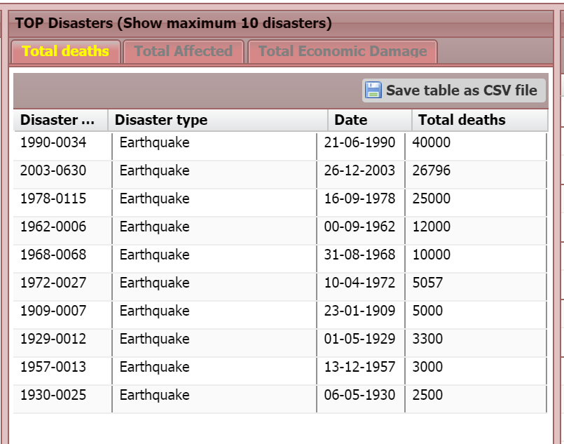
1976.08.28 China Hebei Province Inland earthquake Tangshan earthquake**, M7.3-7.8, The dead and missing number is 242,000-655,000 (750,000 not confirmed) 

* Hurricane Riza hit Mexico. The story will be discussed later.

**Remarks for disaster statistics and international assistance should be made about the Tangshan earthquake. First, the death toll is unclear because of china’s political climate. The earthquake occurred during the late stages of the Cultural Revolution. This makes difficult to have accurate statistical data. The earthquake contributed to the end of the Cultural Revolution. Second, the Chinese government refused to accept international aid from the United Nations and insisted on self-reliance. This influenced disaster exacerbation. One of the worst natural disasters in the world.

Day_84 : Northridge and Kobe

Below is just a comparison between 1994 Northridge and 1995 Kobe earthquakes.

Time
Northridge: :January 17, at 4:30:55 a.m. PST, in 1994 (Mw6.7)
Kobe: January 17, at 05:46:53 JST in 1995 (Mw6.9)

Death toll
Northridge: 57
Kobe: 6,434

Cost
Northridge: Property damage was estimated to be between $13 and $40 billion
Kobe: Around ten trillion yen ($100 billion) in damage, 2.5% of Japan’s GDP at the time.

Both earthquakes are in the costliest disasters (Overall losses) in the world (1980–2004), as you can see in the below figure(Munich Re).

costliesdisasters

However, we need to notice the death toll’s huge gap between the two, even if they happened almost at the same time on the same day with almost the same magnitudes. This tells us natural disaster is not “natural”. The earthquake itself does not kill people; it is just a natural phenomenon. We create “natural” disasters.

Day_82 : Earthquake disasters in Asia (2) – Other countries

The below is the overviews of Earthquakes (Casualties) in Asian earthquake prone countries (except Iran)

Turkey
1999 Izmit Earthquake(M7.4)* Death Toll approx.17000**
1992 Erzincan Earthquake(M6.8) Death Toll approx.500
Note : The one of the main reasons to cause huge numbers of casualties is the same with the Iran cases, building structure, Adobe.

*School Geography Video

** The death toll is different from the sources. This is our challenge.

Pakistan
2005 Kashmir Earthquake (M7.7) Death Toll approx.90,000
1990 Quetta Earthquake (M7.5) Death Toll approx.60,000

India
2001 Gujarat Earthquake (M8.0) Death Toll approx.20000
Note: International assistance efforts influenced the country’s governance negatively.
Illegal house buildings were spread out after the event. This leads India to make a decision
not to accept international assistance efforts (workers,etc.) after the Indian Ocean Tsunami
disaster in 2004
1994 Bihar-Nepal Earthquake (M8.3) Death Toll approx.10000
Note : Nepal did not allow foreigners into the country.
Therefore, the death toll number is inaccurate.
1993 Latur Earthquake (M6.2) Death Toll approx.10000
Note : Stone wall house buildings impact on the high mortality numbers.

Indonesia
2004 Sumatra Earthquake(M9.1)
<Tsunami Leading wave>
The Sri Lanka : Death toll is approx. 35000 Tsunami height is max. 15m
India : Death toll is approx.12000 Tsunami height is max.12m.
<Drawback wave>
Thailand :  Death toll is approx. 8000 Tsunami height is max. 20m.

With earthquake direct impact
Indonesia : Death toll is approx.167000.

Note: They had no Tsunami Warning System. In Thailand, some people go to the seashore to      obtain shells, fishes, or something unusual and not evacuate during the drawback wave              because they lacked tsunami experience and knowledge.

China
1976 Tanshan Earthquake (M7.8) : Death Toll is approx.250,000 (actually estimated 3 times)
USGS’s estimation 655,000
Note :
-Tanshan was a big industrial city
-94% of residential brick wall houses were destroyed
– Chinese gov. refused international assistance
(This makes the disaster worse) …This could be
the deadliest earthquake in the world history

2008 Situan Earthquake (M7.9) : Death Toll is approx. 90,000
-4,000,000 houses were destroyed

The source of the death toll data is NIED DIL***

***National Research Institute for Earth Science and Disaster Prevention, Disasster Information Laboratory.
[ad#ads1]

Day_81 : Earthquake disasters in Asia (1) – Iran

Iran is the one of the most earthquake vulnerable countries in Asia. The following is the high death tolls earthquakes in the country:

2003 Bam Earthquake (M6.8) Death Toll approx.43,000
1990 Majil Earthquake (M7.4) Death Toll approx.50,000
1978 Tabas Earthquake (M7.4) Death Toll approx.18000

Death toll numbers are totally different from the sources.The above death toll data from NIED DIL (National Research Institute for Earth Science and Disaster Prevention, Disaster Information Laboratory) Website**.These gaps tell us a lot of things. This will be explained later.

Especially, the Bam was an ancient city which has many historical buildings and 90% of them were destroyed.

One of the main causes of the casualties is the house building structures, adobe (mud brick). The Adobe is good for thermal mass, however bad for earthquakes. This is very embedded in their culture.
EM-DAT* indicates the Iran’s historical disasters since 1900. We can confirm the Iran is the earthquake prone country as shown in the below table.
Iran

*D. Guha-Sapir, R. Below, Ph. Hoyois – EM-DAT: The CRED/OFDA International Disaster Database –www.emdat.be – Université Catholique de Louvain – Brussels – Belgium.

**http://dil.bosai.go.jp/workshop/05kouza_chiiki/00toppage/index.htm

Day_62 : liquefaction

After the 2011 Great East Japan Earthquake and Tsunami disaster, Chiba prefecture (including Disney Land and Disney Sea) faced liquefaction Problems. The liquefaction means a phenomenon whereby a saturated or partially saturated soil substantially loses strength and stiffness in response to an applied stress, usually earthquake shaking or other sudden change in stress condition, causing it to behave like a liquid *. There were many houses in Chiba prefecture inclined caused by the liquefaction. The people living in the houses lost their health such as dizzy and nauseous symptoms. They also faced financial challenges to fix their houses. Niigata earthquake in 1964 is very famous for the liquefaction as you can see the below Wikipedia site.

NIED(National Research Institute for Earth Science and Disaster Prevention) developed “Ekky” to explain liquefaction for mainly school children.
http://www.bosai.go.jp/activity_general/ekky/ekky.pdf

*Wikipedia
https://en.wikipedia.org/wiki/Soil_liquefaction

Day_51 : Matsushiro Earthquake and Underground Imperial Headquarter

The Matsushiro Earthquake Research Center is located in Nagano Prefecture. It was established in 1967 by the Matsushiro Earthquake Observatory, Japan Meteorological Agency. The center’s background was based on the world’s rare earthquake swarm in the area. From 1965 to 1969, 6,780 earthquakes were observed, and they became social issues.

There are two famous stories about the establishment. The first story is that the mayor, Mr. Nakamura, declared, “We want to have science and research rather than equipment and money” after the earthquake swarm. This attracted the center. The second is that the location was the place where the planned underground imperial headquarters was just before the end of the Second World War. This explains the location, which is deep underground and has a strong structure. So this means the best location to place a seismometer.